Raging Neisse
| Raging Neisse | |
|---|---|
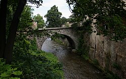
 The Raging Neisse in Bolków | |
| Location | |
| Location | Lower Silesian Voivodeship, Poland |
| Physical characteristics | |
| Source | |
| • location | Origin: Confluence of two streams on the western side of the Kokosz in the Waldenburg Mountains |
| • coordinates | 50°51′40″N 16°04′30″E / 50.8610694°N 16.0749250°E |
| • elevation | 598 m n.p.m. |
| Mouth | |
• location | near Dunino (Dohnau, municipality of Krotoszyce) into the Kaczawa |
• coordinates | 51°09′23″N 16°04′35″E / 51.1563417°N 16.0764417°E |
• elevation | 136 m n.p.m. |
| Length | 51 km |
| Basin features | |
| Progression | Kaczawa→ Oder→ Baltic Sea |
| Landmarks | |
| Waterbodies | Lakes: Słup Lake |
The Raging Neisse[1] (Polish: Nysa Szalona, German: Wütende Neiße or Jauersche Neiße) is a river in Poland. It has a length of about 51 kilometres and flows into the Kaczawa, which in turn flows into the Oder. Its largest tributary is the Little Neisse.
The Raging Neisse rises at a height of 600 metres on the western side of a mountain called the Kokosz on the Waldenburg Heights. It flows down through the lowlands among the foothills of the Sudetes and the heights of Hainau, through the towns of Bolków (Bolkenhain) and Jawor (Jauer). It then merges with the Kaczawa (Katzbach) at a height of 141 metres not far from Jawor near the village of Slup (Schlaup) on the battlefield of the Battle of Katzbach.
During heavy rain the water level of this small river can rise by up to 2.5 metres.
References
- ^ Dodge, Lt Col Theodore Ayrault. Napoleon: A History of the Art of War. Vol. IV, 2014
