
Sudetes
| Sudetes | |
|---|---|
.jpg) | |
| Highest point | |
| Peak | Sněžka/Śnieżka |
| Elevation | 1,603 m (5,259 ft) |
| Coordinates | 50°44′10″N 15°44′24″E / 50.73611°N 15.74000°E |
| Dimensions | |
| Length | 300 km (190 mi) |
| Naming | |
| Native name |
|
| Geography | |
 Divisions of the Sudetes
| |
| Countries | Czech Republic, Poland and Germany |
| Regions/Voivodeships | Ústí nad Labem, Liberec, Hradec Králové, Pardubice, Olomouc, Moravian-Silesian, Lower Silesian, Opole and Saxony |
| Range coordinates | 50°30′N 16°00′E / 50.5°N 16°E |
| Geology | |
| Orogeny | Variscan orogeny (assembly) Alpine orogeny (uplift) |
The Sudetes (/suːˈdiːtiːz/ soo-DEE-teez), also known as the Sudeten Mountains or Sudetic Mountains, is a geomorphological subprovince of the Bohemian Massif province in Central Europe, shared by the Czech Republic, Poland and Germany. They consist mainly of mountain ranges and are the highest part of Bohemian Massif. They stretch from the Saxon capital of Dresden in the northwest across to the region of Lower Silesia in Poland and to the Moravian Gate in the Czech Republic in the east. Geographically the Sudetes are a Mittelgebirge with some characteristics typical of high mountains.[1] Its plateaus and subtle summit relief makes the Sudetes more akin to mountains of Northern Europe than to the Alps.[1]


In the east of the Sudetes, the Moravian Gate and Ostrava Basin separates from the Carpathian Mountains. The Sudetes' highest mountain is Mount Sněžka/Śnieżka 1,603 m (5,259 ft), which is also the highest mountain of the Czech Republic, Bohemia, Silesia, and Lower Silesian Voivodeship, in the Giant Mountains, lying on the border between the Czech Republic and Poland. Mount Praděd (1,491 m/4,893 ft) in the Hrubý Jeseník mountains is the highest mountain of Moravia. Lusatia's highest point (1,072 m/3,517 ft) lies on Mount Smrk/Smrek in the Jizera Mountains, and the Sudetes' highest mountain in Germany, which is also the country's highest mountain east of the river Elbe, is Mount Lausche/Luž (793 m/2,600 ft) in the Zittau Mountains, the highest part of the Lusatian Mountains. The most notable rivers rising in the Sudetes are Elbe, Oder, Spree, Morava, Bóbr, Lusatian Neisse, Eastern Neisse, Jizera and Kwisa. The highest parts of the Sudetes are protected by national parks;[2] Karkonosze and Stołowe (Table) in Poland and Krkonoše in the Czech Republic.
In the west, the Sudetes border with the Elbe Sandstone Mountains. The westernmost point of the Sudetes lies in the Dresden Heath (Dresdner Heide), the westernmost part of the West Lusatian Hill Country and Uplands, in Dresden.
The Sudeten Germans (the German-speaking inhabitants of Czechoslovakia) as well as the Sudetenland (the border regions of Bohemia, Moravia, and Czech Silesia they inhabited) are named after the Sudetes.
Etymology[edit]
The name Sudetes is derived from Sudeti montes, a Latinization of the name Soudeta ore used in the Geographia by the Greco-Roman writer Ptolemy (Book 2, Chapter 10) c. AD 150 for a range of mountains in Germania in the general region of the modern Czech Republic.
There is no consensus about which mountains he meant, and he could for example have intended the Ore Mountains, joining the modern Sudetes to their west, or even (according to Schütte) the Bohemian Forest (although this is normally considered to be equivalent to Ptolemy's Gabreta forest).[3] The modern Sudetes are probably Ptolemy's Askiburgion mountains.[4]
Ptolemy wrote "Σούδητα" in Greek, which is a neuter plural. Latin mons, however, is a masculine, hence Sudeti. The Latin version, and the modern geographical identification, is likely to be a scholastic innovation, as it is not attested in classical Latin literature. The meaning of the name is not known. In one hypothetical derivation, it means Mountains of Wild Boars, relying on Indo-European *su-, "pig". A better etymology perhaps is from Latin sudis, plural sudes, "spines", which can be used of spiny fish or spiny terrain.
Subdivisions[edit]
The Sudetes are usually divided into:
- Eastern Sudetes, in the Czech Republic and Poland
- Golden Mountains
- Hanušovice Highlands
- Hrubý Jeseník with Mt. Praděd, 1,491 m (4,892 ft)
- Mohelnice Depression
- Nízký Jeseník
- Opawskie Mountains
- Králický Sněžník Mountains
- Zábřeh Highlands
- Central Sudetes, in the Czech Republic and Poland
- Western Sudetes, in Germany, the Czech Republic and Poland
- Frýdlant Hills
- Giant Mountains with Mt. Sněžka, 1,603 m (5,259 ft)
- Giant Mountains Foothills
- Ještěd–Kozákov Ridge
- Jizera Mountains
- Kaczawskie Mountains
- Kaczawskie Foothills
- Lusatian Mountains
- Lusatian Highlands
- Lusatian Gefilde
- West Lusatian Foothills
- East Lusatian Foothills
- Rudawy Janowickie
- Jelenia Góra Valley
- Zittau Basin
- Sudeten Foreland
High Sudetes (Polish: Wysokie Sudety, Czech: Vysoké Sudety, German: Hochsudeten) is together name for the ranges of Giant Mountains, Hrubý Jeseník and Králický Sněžník Mountains.
Climate[edit]

The highest mountains, those located along the Czech-Polish border have annual precipitations around 1500 mm.[5] The Table Mountains that reach 919 m have precipitations ranging from 750 mm at lower locations to 920 mm in the upper parts with July being the rainiest month.[6] Snow cover at the Table Mountains typically last 70 to 95 days depending on altitude.[6]
Vegetation[edit]
Settlement, logging and clearance has left forest pockets in the foothills with dense and continuous forest being found in the upper parts of the mountains.[2] Due to logging in the last centuries little remains of the broad-leaf trees like beech, sycamore, ash and littleleaf linden that were once common in the Sudetes. Instead Norway spruce was planted in their place in the early 19th century, in some places amounting to monocultures.[2] To provide more space for spruce plantations various peatlands were drained in the 19th and 20th century.[6] Some spruce plantations have suffered severe damage as the seeds used came from lowland specimens that were not adapted to mountain conditions.[2] Silver fir grow naturally in the Sudetes being more widespread in past times, before clearance since the Late Middle Ages and subsequent industrial pollution reduced the stands.[7]
Many arctic-alpine and alpine vascular plants have a disjunct distribution being notably absent from the central Sudetes despite suitable habitats. Possibly this is the result a warm period during the Holocene (last 10,000 years) which wiped out cold-adapted vascular plants in the medium-sized mountains of the central Sudetes where there was no higher ground that could serve as refugia.[8][A] Besides altitude the distribution of some alpine plants is influenced by soil. This is the case of Aster alpinus that grows preferentially on calcareous ground.[8] Other alpine plants such as Cardamine amara, Epilobium anagallidifolium, Luzula sudetica and Solidago virgaurea occur beyond their altitudinal zonation in very humid areas.[8]
Peatlands are common in the mountains occurring on high plateaus or in valley bottoms. Fens occur at slopes.[6]
Timber line[edit]
The higher mountains of the Sudetes lie above the timber line which is made up of Norway spruce.[5][9] Spruces in wind-exposed areas display features such as flag tree disposition of branches, tilted stems and elongated stem cross sections.[10] Forest-free areas above the timber line have increased historically by deforestation[8] yet lowering of the timber line by human activity is minimal.[9] Areas above the timber line appear discontinuously as "islands" in the Sudetes.[5] In the Giant Mountains the timber line lies at c. 1230 m a.s.l. while to the southeast in the Hrubý Jeseník mountains it lie at c. 1310 m a.s.l.[5] Part of the Hrubý Jeseník mountains have been above the timber line for no less than 5000 years.[5] Mountains rise considerably above the timber line, at most 400 m, a characteristic that sets the Sudetes apart from other Mittelgebirge of Central Europe.[1]
Geology[edit]
Geological research has been hampered by the multinational geography of the Sudetes with and the limitation of studies to state boundaries.[11][B]
Bedrock[edit]

The igneous and metamorphic rocks of the Sudetes originated during the Variscan orogeny and its aftermath.[12] The Sudetes are the northeasternmost accessible part of Variscan orogen as in the North European Plain the orogen is buried beneath sediments.[13] Plate tectonic movements during the Variscan orogeny assembled together four major and two to three lesser tectonostratigraphic terranes.[14][C] The assemblage of the terranes ought to have involved the closure of at least two ocean basins containing oceanic crust and marine sediments.[15] This is reflected in the ophiolites, MORB-basalts, blueschists and eclogites that occur in-between terranes.[14] Various terranes of the Sudetes are likely extensions of the Armorican terrane while other terranes may be the fringes of the ancient Baltica continent.[13] One possibility for the amalgamation of terranes in the Sudetes is that the Góry Sowie-Kłodzko terrane collided with the Orlica-Śnieżnik terrane causing the closure of a small oceanic basin. This event led to obduction of the Central Sudetic ophiolite in the Devonian period. In the Early Carboniferous the joint Góry Sowie-Kłodzko-Orlica-Śnieżnik terrane collided with the Brunovistulian terrane. This last terrane was part of the Old Red Continent and could correspond either to Baltica or the eastern tip of the narrow Avalonia terrane. Also by the Early Carboniferous the Saxothuringian terrane collided with the Góry Sowie-Kłodzko-Orlica-Śnieżnik terrane closing the Rheic Ocean.[16]
Once the main phase of deformation of the orogeny was over basins that had formed in-between metamorphic rock massifs were filled by sedimentary rock in the Devonian and Carboniferous periods.[15] During and after sedimentation large granitic plutons intruded the crust. Viewed in a map today these plutons make up about 15% the Sudetes.[12][15] Granites are of S-type.[13] The granites and grantic-gneisses of Izera in the west Sudetes are disassociated from orogeny and thought to have formed during rifting along a passive continental margin.[17][D] The Karkonosze Granite, also in the west Sudetes, have been dated to have formed c. 318 million years ago at the beginning of the Variscan orogeny.[18] The Karkonosze Granite is intruded by somewhat younger lamprophyre dykes.[18]
A NW-SE to WNW-ESE oriented strike-slip fault —the Intra-Sudetic fault— runs through the length of the Sudetes.[15] The Intra-Sudetic fault is parallel with the Upper Elbe fault and Middle Oder fault.[13] Other main faults at the sudetes are also NW-SE oriented, dextral and of strike slip type. These include the Tłumaczów-Sienna Fault and the Marginal Sudetic Fault.[19]
Volcanism and thermal waters[edit]

There are remnants of lava flows and volcanic plugs in the Sudetes.[20] The volcanic rocks making up these outcrops are of mafic chemistry and include basanite and represent episodes of volcanism in the Oligocene and Miocene periods.[20][E] Volcanism affected not only the Sudetes but also parts of the Sudetic foreland being part of a SW-NE oriented Bohemo-Silesian Belt of volcanic rocks.[20] Mantle xenoliths have been recovered from the lavas of a volcano at Ještěd-Kozákov Ridge in the Czech western Sudetes.[21] These pyroxenite xenoliths arrived to surface from approximate depths of 35, 70 and 73 km and indicate a complex history for the mantle beneath the Sudetes.[21]
There are thermal springs in the Sudetes with measured temperatures of 29 to 44 °C. Drilling has revealed the existence of waters at 87 °C at depths of 2000 m. These modern waters are believed to be associated to the Late Cenozoic volcanism in Central Europe.[22]
Uplift and landforms[edit]

The Sudetes forms the NE border of the Bohemian Massif.[13] In detail the Sudetes is made up of a series of massifs that are rectangular and rhomboid in plan view.[23] These mountains corresponds to horsts and domes separated by basins, including grabens.[24] The mountains took their present form after the Late Mesozoic retreat of the seas from the area which left the Sudetes subject to denudation for at least 65 million years.[23] This meant that during the Late Cretaceous and Early Cenozoic 8 to 4 km of rock was eroded from the top of what is now the Sudetes.[25] Concurrently with the Cenozoic denudation the climate cooled due to the northward drift of Europe. The collision between Africa and Europe has resulted in the deformation and uplift of the Sudetes.[23] As such the uplift is related to the contemporary rise of the Alps and Carpathians.[23][11][F] Uplift was accomplished by the creation or reactivation of numerous faults leading to a reshaping of the relief by renewed erosion.[12] Various "hanging valleys" attest to this uplift.[11] Block tectonics has uplifted or sunken crustal blocks. While the Late Cenozoic uplift has uplifted the Sudetes as a whole some grabens precede this uplift.[19]
.jpg)
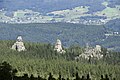
Weathering during the Cenozoic led to the formation of an etchplain in parts of Sudetes. While this etchplain has been eroded various landforms and weathering mantles have been suggested to attest its former existence.[12] At present the mountain range shows a remarkable diversity of landforms.[23] Some of the landforms present are escarpments, inselbergs, bornhardts, granitic domes, tors, flared slopes and weathering pits.[12] Various escarpments have originated from faults and may reach heights of up to 500 m.[11] To the northeast the Sudetes is separated from the Sudetic foreland by a sharp mountain front made up of an escarpment linked to the Sudetic Marginal Fault.[26] Near Kaczawa this escarpment reaches 80 to 120 m in height. The relative influence of Pliocene-Quaternary tectonic movements and erosion in shaping the mountain landscape may vary along the northern front of the Sudetes.[26]
During the Quaternary glaciations the Giant Mountains was the most glaciated part of the Sudetes. Evidence of this are its glacial cirques and the glacial valleys that develop next to it.[1] The precise timing of the glaciations in the Sudetes is poorly constrained.[1] Parts of the Sudetes remained free from glacier ice developing permafrost soils and periglacial landforms such as rock glaciers, nivation hollows, patterned ground, blockfields, solifluction landforms, blockstreams, tors and cryoplanation terraces.[9] The occurrence or not of these periglacial landforms depends on altitude, the steepness and direction of slopes and the underlying rock type.[9]
Mass wasting[edit]
Other than debris flows there is little contemporary mass wasting in the mountains.[1] Avalanches are common in the Sudetes.[1]
History[edit]


The area around the Sudetes had by the 12th century been relatively densely settled[2] with agriculture and settlements expanding further in the High Middle Ages from the 13th century onward.[6] The majority of settlers were Germans from neighbouring Silesia, founding typical Waldhufendörfer.[27] As this trend went on thinning of forest and deforestation had turned clearly unsustainable by the 14th century.[7] In the 15th and 16th centuries agriculture had reached the inner part of Table Mountains in the Central Sudetes.[2] Destruction and degradation of the Sudetes forest peaked in the 16th and 17th centuries[7] with demand of firewood coming from glasshouses that operated through the area in the early modern period.[2]
Some limited form of forest management begun in the 18th century[7] while in the industrial age demand for firewood was sustained by metallurgic industries in the settlements and cities around the mountains.[2] In the 19th century the Central Sudetes had an economic boom with sandstone quarrying and a flourishing tourism industry centered on the natural scenery. Despite this there was at least since the 1880s a trend of depopulation of villages and hamlets which continued into the 20th century.[28] Since World War II various areas that were cleared of forest have been re-naturalized.[28] Industrial activity across Europe has caused considerable damage to the forests as acid rain and heavy metals has arrived with westerly and southwesterly winds.[2] Silver firs have proven particularly vulnerable to industrial soil contamination.[7]
Sudetes and "Sudetenland"[edit]

After World War I, the name Sudetenland came into use to describe areas of the First Czechoslovak Republic with large ethnic German populations. In 1918, the short-lived rump state of German-Austria proclaimed a Province of the Sudetenland in northern Moravia and Austrian Silesia around the city of Opava (Troppau).
The term was used in a wider sense when on 1 October 1933 Konrad Henlein founded the Sudeten German Party and in Nazi German parlance Sudetendeutsche (Sudeten Germans) referred to all autochthonous ethnic Germans in Czechoslovakia. They were heavily clustered in the entire mountainous periphery of Czechoslovakia—not only in the former Moravian Provinz Sudetenland but also along the northwestern Bohemian borderlands with German Lower Silesia, Saxony and Bavaria, in an area formerly called German Bohemia. In total, the German minority population of interwar Czechoslovakia numbered around 20% of the total national population.
Sparking the Sudeten Crisis, Adolf Hitler got his future enemies Britain and France to concede the Sudetenland with most of the Czechoslovak border fortifications in the 1938 Munich Agreement, leaving the remainder of Czechoslovakia shorn of its natural borders and buffer zone, finally occupied by Germany in March 1939. After being annexed by Nazi Germany, much of the region was redesignated as the Reichsgau Sudetenland.
After World War II, most of the previous population of the Sudetes was forcibly expelled on the basis of the Potsdam Agreement and the Beneš decrees, and the region was resettled by new Polish and Czechoslovak citizens. A considerable proportion of the Czechoslovak populace thereafter strongly objected to the use of the term Sudety. In the Czech Republic the designation Krkonošsko-jesenická subprovincie is used in academic context and usually only the discrete Czech names for the individual mountain ranges (e.g. Giant Mountains) appear, as under Subdivisions above.
Economy and tourism[edit]

Part of the economy of the Sudetes is dedicated to tourism. Coal mining towns like Wałbrzych have re-oriented their economies towards tourism since the decline of mining in the 1980s.[29] As of 2000 scholar Krzysztof R. Mazurski judged that the Sudetes, much like Poland's Baltic coast and the Carpathians, were unlikely to attract much foreign tourism.[29] Sandstone was quarried in Sudetes during the 19th and 20th centuries.[28] Likewise volcanic rock has also been quarried[20] to such degree untouched volcanoes are scarce.[30] Sandstone labyrinths have been a notable tourist attraction since the 19th century with considerable investments being done in projecting trails some of which involve rock engineering.[28]
In the Sudetes there are many spa towns with sanatoria. In many places the developed tourist base – hotels, guest houses, ski infrastructure.
The nearest international airports are Dresden Airport in Dresden and Wrocław Airport in Wrocław.
Notable towns[edit]
Towns in this area with more than 10,000 inhabitants include:
|
|
|
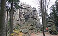
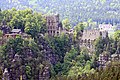
Gallery[edit]
-

-
-
 "Hell" on Szczeliniec Wielki, Table Mountains
 -
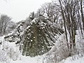
-
 Góry Sokole
 -

-

-
-

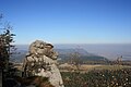
-
 A view from Zygmuntówka refuge, Owl Mountain range (Góry Sowie)
 -
-
 Tripoint of Germany, Czech Republic, and Poland in the Eastern Upper Lusatia
 -
 Monastery ruins on the Oybin
 -
 Zittau Mountains with the Hochwald mountain
 -
 Rock Gate (Felsentor)
 -

-
 View towards the Jizerskohorské bučiny National Nature Reserve
 -


.jpg)


.jpg)

See also[edit]
- Mount Ślęża
- Main Sudetes Trail
- Książ
- Wambierzyce
- Kłodzko Fortress
- Srebrna Góra
- Chojnik
- Niesytno Castle
- Grüssau Abbey
- Izera railway
- Lower Silesian Voivodeship
- Tourism in Poland
- Crown of Polish Mountains
- Wilczka Falls Nature Reserve
Notes[edit]
- ^ Not to be confused with a glacial refugium.
- ^ Alfred Jahn's geomorphological studies of the Polish Sudetes in 1953 and 1980 exemplify this.[11]
- ^ Geologist Tom McCann lists the main Variscan terranes that make up much of the Sudetes as the Moldanubian, Góry-Sowie-Klodzko, Teplá Barriandian, Lusatia-Izera terrane, Brunovistulian terrane. The first three lie in the central Sudetes while the last two in the west and central Sudetes.[15]
- ^ Contrary to this case S-type granites are typically thought to come into existence concurrently or slightly after orogeny.[17]
- ^ Some volcanic rocks may be as young as of Early Pliocene age.[20]
- ^ Fission track dating yields various possibilities about the Late Cenozoic uplift of the Sudetes. Possibly the last uplift pulse begun 7 to 5 million years ago.[25]
References[edit]
- ^ a b c d e f g Migoń, Piort (2008). "High-mountain elements in the geomorphology of the Sudetes, Bohemian Massif, and their significance". Geographia Polonica. 81 (1): 101–116.
- ^ a b c d e f g h i Mazurski, Krzysztof R. (1986). "The destruction of forests in the polish Sudetes Mountains by industrial emissions". Forest Ecology and Management. 17 (4): 303–315. doi:10.1016/0378-1127(86)90158-1.
- ^ Schütte (1917), Ptolemy's maps of northern Europe, a reconstruction of the prototype, Kjøbenhavn, H. Hagerup, p. 141
- ^ Schütte (1917), Ptolemy's maps of northern Europe, a reconstruction of the prototype, Kjøbenhavn, H. Hagerup, p. 56
- ^ a b c d e Treml, Václav; Jankovská, Vlasta; Libor, Petr (2008). "Holocene dynamics of the alpine timberline in the High Sudetes". Biologia. 63 (1): 73–80. doi:10.2478/s11756-008-0021-3.
- ^ a b c d e Glina, Bartłomiej; Malkiewicz, Małgorzata; Mendyk, Łukasz; Bogacz, Adam; Woźniczka, Przemysław (2016). "Human‐affected disturbances in vegetation cover and peatland development in the late Holocene recorded in shallow mountain peatlands (Central Sudetes, SW Poland)". Boreas. 46 (2): 294–307. doi:10.1111/bor.12203. S2CID 133200850.
- ^ a b c d e Barzdajn, Wladyslaw (2004). "Rehabilitation of silver fir (Abies alba Mill) populations in the Sudetes". Report of the second (20–22 September 2001, Valsaín, Spain) and third (17–19 October 2002, Kostrzyca, Poland) meetings (Report). pp. 45–51.
- ^ a b c d Kwiatkowski, Paweł; Krahulec, František (2016). "Disjunct Distribution Patterns in Vascular Flora of the Sudetes". Ann. Bot. Fennici. 53 (1–2): 91–102. doi:10.5735/085.053.0217. S2CID 86962680.
- ^ a b c d Křížek, M. (2007). "Periglacial landforms above the alpine timberline in the High Sudetes" (PDF). In Goudie, A.S.; Kalvoda, J. (eds.). Geomorphological variations. Prague: ProGrafiS Publ. pp. 313–338.
- ^ Wistuba, Małgorzata; Papciak, Tomasz; Malik, Ireneusz; Barnaś, Agnieszka; Polowy, Marta; Pilorz, Wojciech (2014). "Wzrost dekoncentryczny świerka pospolitego jako efekt oddziaływania dominującego kierunku wiatru (przykład z Hrubégo Jeseníka, Sudety Wschodnie)" [Eccentric growth of Norway spruce trees as a result of prevailing winds impact (example from Hrubý Jeseník, Eastern Sudetes)]. Studia I Materiały CEPL W Rogowie (in Polish). 40 (3): 63–73.
- ^ a b c d e Różycka, Milena; Migoń, Piotr (2017). "Tectonic geomorphology of the Sudetes Mountains (Central Europe) – A review and re-apprisal". Annales Societatis Geologorum Poloniae. 87: 275–300. doi:10.14241/asgp.2017.016.
- ^ a b c d e Migoń, Piotr (1996). "Evolution of granite landscapes in the Sudetes (Central Europe): some problems of interpretation". Proceedings of the Geologists' Association. 107: 25–37. doi:10.1016/s0016-7878(96)80065-4.
- ^ a b c d e Mazur, Stanisław; Alexandrowski, Paweł; Kryza, Ryszard; Oberc-Dziedzic, Teresa (2006). "The Variscan Orogen in Poland". Geological Quarterly. 50 (1): 89–118.
- ^ a b Mazur, S.; Aleksandrowski, P. (2002). "Collage tectonics in the northeasternmost part of the Variscan Belt: the Sudetes, Bohemian Massif". Geological Society, London, Special Publications. 201 (1): 237–277. Bibcode:2002GSLSP.201..237A. doi:10.1144/gsl.sp.2002.201.01.12. S2CID 140166878.
- ^ a b c d e McCann, Tom (2008). "Sudetes". In McCann, Tom (ed.). The Geology of Central Europe, Volume 1: Pre-Cambrian and Palaeozoic. Vol. 1. London: The Geological Society. p. 496. ISBN 978-1-86239-245-8.
- ^ Mazur, Stanisław; Aleksandrowski, Paweł; Turniak, Krzysztof; Awdankiewicz, Marek (2007). "Geology, tectonic evolution and Late Palaeozoic magmatism of Sudetes – an overview". Granitoids in Poland. Vol. 1. pp. 59–87.
- ^ a b Oberc-Dziedzic, T.; Pin, C.; Kryza, R. (2005). "Early Palaeozoic crustal melting in an extensional setting: petrological and Sm–Nd evidence from the Izera granite-gneisses, Polish Sudetes". International Journal of Earth Sciences. 94 (3): 354–368. Bibcode:2005IJEaS..94..354O. doi:10.1007/s00531-005-0507-y. S2CID 129243888.
- ^ a b Awdankiewicz, Marek; Awdankiewicz, Honorata; Kryza, Ryszard; Rodinov, Nickolay (2009). "SHRIMP zircon study of a micromonzodiorite dyke in the Karkonosze Granite, Sudetes (SW Poland): age constraints for late Variscan magmatism in Central Europe". Geological Magazine. 147 (1): 77–85. doi:10.1017/S001675680999015X. S2CID 129844097.
- ^ a b Józef, Oberc (1991). "Systems of main longitudinal strike-slip faults in the vicinity of the Góry Sowie Block (Sudetes)". Kwartalnik Geologiczny. 35 (4): 403–420.
- ^ a b c d e Birkenmajer, Krzysztof; Pécskay, Zóltan; Grabowski, Jacek; Lorenc, Marek W.; Zagożdżon, Paweł P. (2002). "Radiometric dating of the Tertiary volcanics in Lower Silesia, Poland. II. K-Ar and palaeomagnetic data from Neogene basanites near Lądek Zdrój, Sudetes Mts". Annales Societatis Geologorum Poloniae. 72: 119–129.
- ^ a b Ackerman, Lukáš; Petr, Špaček; Medaris, Jr., Gordon; Hegner, Ernst; Svojtka, Martin; Ulrych, Jaromír (2012). "Geochemistry and petrology of pyroxenite xenoliths from Cenozoic alkaline basalts, Bohemian Massif" (PDF). Journal of Geosciences. 57: 199–219. doi:10.3190/jgeosci.125.
- ^ Dowgiałło, Jan (2000). "The Sudetic geothermal region of Poland–new findings and further prospects" (PDF). Proceedins of the World Geothermal Congress. World Geothermal Congress. Kyushu–Tohoku, Japan. pp. 1089–1094.
- ^ a b c d e Migoń, Piotr (2011). "Geomorphic Diversity of the Sudetes – Effects of the structure and global change superimposed". Geographia Polonica. 2: 93–105.
- ^ Migoń, Piotr (1997). "Tertiary etchsurfaces in the Sudetes Mountains, SW Poland: a contribution to the pre-Quaternary morphology of Central Europe". In Widdowson, M. (ed.). Palaeosurfaces: Recognition, Reconstruction and Palaeoenvironmental Interpretation. Geological Society Special Publication. London: The Geological Society.
- ^ a b Aramowicz, Aleksander; Anczkiewicz, Aneta A.; Mazur, Stanisław (2006). "Fission-track dating of apatite from the Góry Sowie Massif, Polish Sudetes, NE Bohemian Massif: implications for post-Variscan denudation and uplift". Neues Jahrbuch für Mineralogie – Abhandlungen. 182 (3): 221–229. doi:10.1127/0077-7757/2006/0046.
- ^ a b Migoń, Piotr; Łach, Janusz (1998). "Geomorphological evidence of neotectonics in the Kaczawa sector of the Sudetic Marginal Fault, southwestern Poland". Geologia Sudetica. 31: 307–316.
- ^ Charles Higounet. Die deutsche Ostsiedlung im Mittelalter (in German). p. 167.
- ^ a b c d Migoń, Piotr; Latocha, Agnieszka (2013). "Human interactions with the sandstone landscape of central Sudetes". Applied Geography. 42: 206–216. doi:10.1016/j.apgeog.2013.03.015.
- ^ a b Mazurski, Krzysztof R. (2000). "Geographical perspectives on Polish tourism". GeoJournal. 50 (2/3): 173–179. doi:10.1023/a:1007180910552. S2CID 153221684.
- ^ Migoń, Piotr; Pijet-Migoń, Edyta (2015). "Overlooked Geomorphological Component of Volcanic Geoheritage – Diversity and Perspectives for Tourism Industry, Pogórze Kaczawskie Region, SW Poland". Geoheritage. 8 (4): 333–350. doi:10.1007/s12371-015-0166-8.
External links[edit]
Silesia topics | |||||||||||||||||||||||||||||
|---|---|---|---|---|---|---|---|---|---|---|---|---|---|---|---|---|---|---|---|---|---|---|---|---|---|---|---|---|---|
| |||||||||||||||||||||||||||||
| |||||||||||||||||||||||||||||
| |||||||||||||||||||||||||||||
Central Uplands of Germany | ||
|---|---|---|
|  | |
| International | |
|---|---|
| National | |