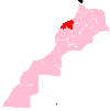
Ras El Ain, Morocco
Appearance
Ras El Ain | |
|---|---|
Town | |
 | |
| Country | |
| Region | Casablanca-Settat |
| Province | Settat Province |
| Population (2004) | |
• Total | 3,638 |
| Time zone | UTC+0 (WET) |
| • Summer (DST) | UTC+1 (WEST) |
Ras El Ain is a town in Settat Province, Casablanca-Settat, Morocco. According to the 2004 census it has a population of 3638.[1]
References
- ^ "World Gazetteer". Archived from the original on 2012-12-05.

