Saffron Hill


Saffron Hill is the name of a street in the south eastern corner of the London Borough of Camden, between Farringdon Road and Hatton Garden. The name of the street derives from the fact that it was at one time part of an estate on which saffron grew.
In 1850 it was described as a squalid neighbourhood, the home of paupers and thieves. In Charles Dickens's 1837 novel Oliver Twist (Chapter 8), the Artful Dodger leads Oliver to Fagin's den in Field Lane, the southern extension of Saffron Hill: "a dirty and more wretched place he [Oliver] had never seen. The street was very narrow and muddy, and the air was impregnated with filthy odours".[1]
Saffron Hill is mentioned in the Arthur Conan Doyle Sherlock Holmes story "The Adventure of the Six Napoleons", as the Italian Quarter where the Venucci family can be found.
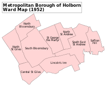
Saffron Hill formed part of the liberty of Saffron Hill, Hatton Garden, Ely Rents and Ely Place which became part of the County of London in 1889. It was abolished in 1900 and formed part of the Metropolitan Borough of Holborn until 1965.
Saffron Hill has become more residential in recent years with the building of several blocks of 'luxury' apartments, including Da Vinci House situated in the former "Punch magazine" printworks and the architecturally distinctive Ziggurat Building.
References
- ^ Dickens, Charles (1838). Oliver Twist: or, The Parish Boy's Progress. New York: Carey, Lea & Blanchard. p. 43. ISBN 91-1-937201-9. Retrieved 28 December 2009.
{{cite book}}:|work=ignored (help)
External links
51°31′12.60″N 0°06′23.91″W / 51.5201667°N 0.1066417°W


