Singac, New Jersey
Appearance
Singac, New Jersey | |
|---|---|
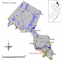
 Map of Little Falls in Passaic County; Singac is located in the western end of Little Falls. Inset: Location of Passaic County highlighted in the State of New Jersey. | |
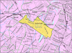
 Census Bureau map of Little Falls, New Jersey, in which Singac is located at its western end | |
| Coordinates: 40°53′03″N 74°14′37″W / 40.884254°N 74.243539°W[1][2] | |
| Country | |
| State | |
| County | Passaic |
| Township | Little Falls |
| Area | |
| • Total | 0.498 sq mi (1.289 km2) |
| • Land | 0.466 sq mi (1.207 km2) |
| • Water | 0.032 sq mi (0.082 km2) 6.34% |
| Elevation | 167 ft (51 m) |
| Population | |
| • Total | 3,618 |
| • Density | 7,763.6/sq mi (2,997.5/km2) |
| Time zone | UTC-5 (Eastern (EST)) |
| • Summer (DST) | UTC-4 (Eastern (EDT)) |
| ZIP code | 07424[5] |
| Area code(s) | 862/973 |
| FIPS code | 3467770[1][6] |
| GNIS feature ID | 02584027[1][7][8] |
Singac (pronounced SING-ack[citation needed]) is an unincorporated community and census-designated place (CDP) located within Little Falls Township, in Passaic County, New Jersey, United States.[9][10][11][12] As of the 2010 United States Census, the CDP's population was 3,618.[4]
Geography
According to the United States Census Bureau, the CDP had a total area of 0.498 square miles (1.289 km2), including 0.466 square miles (1.207 km2) of land and 0.032 square miles (0.082 km2) of water (6.34%).[1][2]
Singac is a neighborhood in the western end of Little Falls Township. It is bounded to the north by the Passaic River. New Jersey Route 23, known as the Newark-Pompton Turnpike or Pompton Avenue, runs north-south through the community.
Demographics
References
- ^ a b c d e Gazetteer of New Jersey Places, United States Census Bureau. Accessed July 21, 2016.
- ^ a b US Gazetteer files: 2010, 2000, and 1990, United States Census Bureau. Accessed September 4, 2014.
- ^ U.S. Geological Survey Geographic Names Information System: Singac Census Designated Place, Geographic Names Information System. Accessed January 16, 2013.
- ^ a b DP-1 - Profile of General Population and Housing Characteristics: 2010 Demographic Profile Data for Singac CDP, New Jersey, United States Census Bureau. Accessed January 16, 2013.
- ^ Look Up a ZIP Code for Singac, NJ, United States Postal Service. Accessed January 16, 2013.
- ^ American FactFinder, United States Census Bureau. Accessed September 4, 2014.
- ^ US Board on Geographic Names, United States Geological Survey. Accessed September 4, 2014.
- ^ A Cure for the Common Codes: New Jersey, Missouri Census Data Center. Accessed January 16, 2013.
- ^ GCT-PH1 - Population, Housing Units, Area, and Density: 2010 - County -- County Subdivision and Place from the 2010 Census Summary File 1 for Passaic County, New Jersey, United States Census Bureau. Accessed January 12, 2013.
- ^ 2006-2010 American Community Survey Geography for New Jersey, United States Census Bureau. Accessed January 12, 2013.
- ^ New Jersey: 2010 - Population and Housing Unit Counts - 2010 Census of Population and Housing (CPH-2-32), United States Census Bureau, August 2012. Accessed January 12, 2013.
- ^ Locality Search, State of New Jersey. Accessed April 19, 2015.

