Steamboat Lake State Park
Appearance
| Steamboat Lake State Park | |
|---|---|
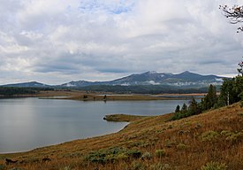
 The park in late summer. | |
| Location | Routt County, Colorado, United States |
| Nearest city | Steamboat Springs, CO |
| Coordinates | 40°48′31″N 106°57′09″W / 40.80861°N 106.95250°W |
| Area | 2,820 acres (1,140 ha) |
| Established | 1967 |
| Visitors | 348,683[1] (in 2009-10) |
| Governing body | Colorado Parks & Wildlife |
Steamboat Lake State Park is a Colorado state park located in Routt County 27 miles (43 km) north of Steamboat Springs, Colorado, and near the community of Hahns Peak Village. The 2,820-acre (1,140 ha) park, established west of Hahns Peak in 1967, includes a 1,101 acres (446 ha) reservoir. Park facilities include a visitors center, marina,[2] boat ramps, campsites, cabins, picnic sites and 5.5 miles (8.9 km) of hiking trails. Plant communities include sagebrush shrubland, quaking aspen and lodgepole pine forests, willow carr and marsh. Commonly seen mammalian wildlife species include mule deer and red fox. The reservoir attracts many species of shorebirds and waterfowl, including sandhill cranes that nest in the wetland areas.
References
- ^ "Steamboat Lake Fact Sheet" (PDF). Colorado Parks & Wildlife. Retrieved June 29, 2013.
- ^ "Steamboat Lake State Park". Colorado Parks & Wildlife. Retrieved June 29, 2013.

