Surrey County, Jamaica
Appearance
Surrey County | |
|---|---|
 | |
| Country | Jamaica |
| Capital | Kingston |
 |
|---|
|
|
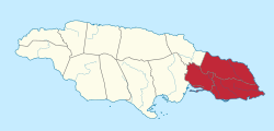
Surrey is the easternmost and the smallest by area of the three historic counties into which Jamaica is divided. It was created in 1758, and is divided into four parishes.[1]
History
Jamaica's three counties (Surrey, Middlesex and Cornwall) were established in 1758 to facilitate the holding of courts along the lines of the British County court system. [2] Surrey was named after the English county in which Kingston upon Thames is found.[2] Kingston was its county town.[2]
Parish list and map

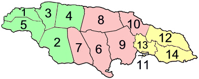
The county of Surrey is shown in yellow.
| Surrey County | ||||
| On map |
Parish | Area km² |
Population Census 2011 |
Capital |
| 11 | Kingston Parish(1) (2) | 21.8 | 96,052 | Kingston |
| 12 | Portland | 814.0 | 80,205 | Port Antonio |
| 13 | Saint Andrew(1) | 430.7 | 555,828 | Half Way Tree |
| 14 | Saint Thomas | 742.8 | 91,604 | Morant Bay |
| Surrey County | 2,009.3 | 823,689 | ||
| Jamaica total | 10,990.5 | 2,607,631 | Kingston | |
(1) Kingston Parish and Saint Andrew Parish together form Kingston and St Andrew Corporation.
(2) Kingston Parish does not encompass all of Kingston.
References
- ^ "A special Gleaner Feature". Jamaica Gleaner.
- ^ a b c Higman, B W; Hudson (2009). Jamaican Place Names. B J (1st ed.). Mona, Jamaica: University of the West Indies Press. p. 31. ISBN 978-976-640-217-4.
