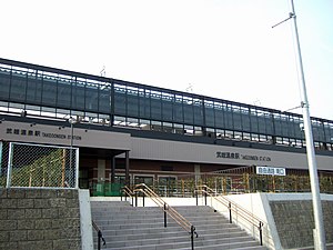
Takeo-Onsen Station
Takeo-Onsen Station 武雄温泉駅 | |
|---|---|
 South entrance | |
| General information | |
| Location | Takeo, Saga Japan |
| Operated by | Kyushu Railway Company |
| Line(s) | Sasebo Line |
| History | |
| Opened | 1895 |
| Previous names | Karasaki; Takeo (until 1975) |
Takeo-Onsen Station (武雄温泉駅, Takeo-Onsen eki) is a train station on Sasebo Line operated by Kyūshū Railway Company in Takeo, Saga, Japan. The station opened on May 5, 1895.
Structure
1 elevated island platform. 2 elevated tracks and south station office were completed in 2008-02-17. 1 more track and north station office are under construction and they will be completed in 2009. All day manned station. There are reservation counter, ticket machine, elevator, escalator. There are no machine gates.
| 2 | ■Limited express Midori, Huis Ten Bosch | for Saga, Hakata |
|---|---|---|
| ■Sasebo Line | for Hizen-Yamaguchi, Tosu | |
| 3 | ■Limited express Midori, Huis Ten Bosch | for Sasebo, Huis Ten Bosch |
| ■Sasebo Line | for Arita, Haiki |
History
- 1895-05-05 Opened as Karasaki Station
- 1897-07-10 Named to Takeo Station
- 1975-06-19 Named to Takeo Onsen Station
- 1987-04-01 Inherited by JR Kyūshū
- 2008-02-17 Elevated station opened
Adjacent stations
| ← | Service | → | ||
|---|---|---|---|---|
| Sasebo Line | ||||
| Takahashi | Local | Saga | ||
| Hizen-Yamaguchi | Limited express Huis Ten Bosch | Arita | ||
| Hizen-Yamaguchi | Limited Express Midori | Arita | ||
Kyūshū Shinkansen Nagasaki route
Takeo-Onsen Station is planned to be a station of Kyūshū Shinkansen Nagasaki route(West-Kyūshū route). In 2008-03-26 Minister of Land, Infrastructure, Transport and Tourism of Japan permitted to start the construction.
gallery
-
place for planned Shinkansen platforms (March 2008)
-
elevated platform (March 2008)
See also
External links
33°11′48″N 130°01′25″E / 33.19673°N 130.023514°E


