
Virgin Gorda

Virgin Gorda is the third-largest (after Tortola and Anegada) and second most populous of the British Virgin Islands (BVI). Located at approximately 18 degrees, 48 minutes North, and 64 degrees, 30 minutes West, it covers an area of about 8 square miles (21 km2). Christopher Columbus is said to have named the island "The Fat Virgin", because the island's profile on the horizon looks like a fat woman lying on her side.
The main town is Spanish Town on the southwestern part of the island.
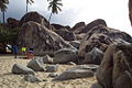
An unusual geologic formation known as "The Baths" located on the southern end of the island makes Virgin Gorda one of the BVI's major tourist destinations. At The Baths, the beach shows evidence of the island's volcanic origins, as huge granite boulders lie in piles on the beach, forming scenic grottoes that are open to the sea. North of the Baths is the Virgin Gorda Yacht Harbor, formerly owned by Little Dix Bay. The most notable ruin on Virgin Gorda is the old Copper Mine. In the island's North Sound is the high-end Bitter End Yacht Club, now a five-star resort.
Transportation
Boat ferry service from Tortola and the Virgin Gorda Airport serves the island. In January 2010, Virgin Gorda Airport was restricted to a very small list of airlines by Air Safety Support International, the territory's aviation regulatory agency, which demanded that the airport be brought in line with international safety standards. The airport reopened in December of 2010.
Tourists come from neighbouring islands such as Tortola and St. Thomas by boat and return to these islands for air transportation.
Education
The British Virgin Islands operates several government schools.[1] Virgin Gorda residents are served by Robinson O'Neal Memorial Primary School, a primary school, and Bregado Flax Educational Centre, a combined primary and secondary school which opened in 1982.[2] In 2000 the government created plans to create a primary school on the island.[3]
Gallery
-
 An overview of the Island
 -
 The Baths, Virgin Gorda
 -
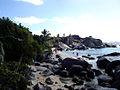
 Huge boulders litter the beach at The Baths
 -
 Another view of boulders at The Baths
 -
 Inside The Baths
 -
 Sunset at Virgin Gorda
 -
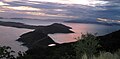 Sunset at Gorda Peak
 -
 The Copper Mine


References
- ^ BVI Government
- ^ "Bregado Flax Graduates 21 Students". Island Sun. 2002-07-12. Retrieved 2008-05-27.
- ^ Stoutt, Jerinice (2006-08-23). "Virgin Gorda Primary School". Development Planning Unit. Retrieved 2008-05-27. [dead link]
18°28′54.8″N 64°23′20.95″W / 18.481889°N 64.3891528°W
This British Virgin Islands location article is a stub. You can help Wikipedia by expanding it. |