
Wiesenau
Wiesenau | |
|---|---|
 Village church | |
 Coat of arms | |
Location of Wiesenau within Oder-Spree district  | |
 Wiesenau  Wiesenau | |
| Coordinates: 52°13′59″N 14°35′59″E / 52.23306°N 14.59972°E | |
| Country | Germany |
| State | Brandenburg |
| District | Oder-Spree |
| Municipal assoc. | Brieskow-Finkenheerd |
| Government | |
| • Mayor | Rainer Bublak (SPD) |
| Area | |
| • Total | 29.59 km2 (11.42 sq mi) |
| Elevation | 39 m (128 ft) |
| Population (2022-12-31)[1] | |
| • Total | 1,248 |
| • Density | 42/km2 (110/sq mi) |
| Time zone | UTC+01:00 (CET) |
| • Summer (DST) | UTC+02:00 (CEST) |
| Postal codes | 15295 |
| Dialling codes | 033609 |
| Vehicle registration | LOS |
| Website | http://www.brieskow-finkenheerd.de/ |
Wiesenau is a municipality in the Oder-Spree district, in Brandenburg, Germany.[2]
Demography
-
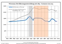 Development of population since 1875 within the current Boundaries (Blue Line: Population; Dotted Line: Comparison to Population development in Brandenburg state; Grey Background: Time of Nazi Germany; Red Background: Time of communist East Germany)

|
|
References
- ^ "Bevölkerungsentwicklung und Bevölkerungsstandim Land Brandenburg Dezember 2022" (PDF). Amt für Statistik Berlin-Brandenburg (in German). June 2023.
- ^ Mapa Polski 1:500 000 Wojskowy Instytut Geograficzny Sztabu Generalnego W.P., Warszawa 1947
- ^ Detailed data sources are to be found in the Wikimedia Commons.Population Projection Brandenburg at Wikimedia Commons
Towns and municipalities in Oder-Spree | ||
|---|---|---|
|  | |
Wikimedia Commons has media related to Wiesenau.
| International | |
|---|---|
| National | |
This Brandenburg location article is a stub. You can help Wikipedia by expanding it. |