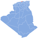
Zemmouri
Appearance
Zemmouri
زموري | |
|---|---|
Commune and town | |
 | |
 | |
| Coordinates: 36°47′N 3°36′E / 36.783°N 3.600°E | |
| Country | |
| Province | Boumerdès Province |
| Population (2008) | |
| • Total | 26,408 |
| Time zone | UTC+1 (CET) |
Zemmouri is a town and commune in Boumerdès Province, Algeria. According to the 1998 census it has a population of 21,012.[1]
The disastrous 2003 Boumerdès earthquake led to the discovery of a thrust fault; it was subsequently named after the town. The fault has since been incorporated into seismic hazard maps, which will serve as an important guideline for public safety.[2]
References
- ^ Statoids
- ^ Curtis L. Edwards, ed. (2004). Zemmouri, Algeria, Mw6.8 Earthquake of May 21, 2003. Reston, VA: ASCE, TCLEE. ISBN 9780784407462.


