Zanda County
Zanda County
札达县 • རྩ་མདའ་རྫོང་། Tsamda | |
|---|---|
 Landscape of Zanda, viewed from Tsaparang. | |
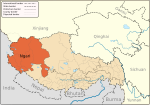
 Location of Zanda County within Tibet Autonomous Region | |
| Coordinates (Zanda County government): 31°29′03″N 79°41′11″E / 31.48417°N 79.68639°E | |
| Country | China |
| Autonomous region | Tibet |
| Prefecture | Ngari |
| County seat | Tholing |
| Area | |
| • Total | 24,601.59 km2 (9,498.73 sq mi) |
| Population (2020)[1] | |
| • Total | 8,454 |
| • Density | 0.34/km2 (0.89/sq mi) |
| Time zone | UTC+8 (China Standard) |
| Website | zd |
| Zanda County | |||||||||
|---|---|---|---|---|---|---|---|---|---|
| Chinese name | |||||||||
| Simplified Chinese | 札达县 | ||||||||
| Traditional Chinese | 札達縣 | ||||||||
| |||||||||
| Tibetan name | |||||||||
| Tibetan | རྩ་མདའ་རྫོང་། | ||||||||
| |||||||||
Zanda County or Tsamda County (Tibetan: རྩ་མདའ་རྫོང, Chinese: 札达县) is a county in the Ngari Prefecture to the extreme west of the Tibet Autonomous Region of China. Its seat of power is at Tholing, the former capital of the Guge kingdom.
Zanda is said to mean “a place where there is grass downstream”,[2][unreliable source?] an allusion to the grassy river bed of the Sutlej river that flows through the county. Ancient Zanda horse (Hipparion zandaense) skeletons have been found in Zanda County's Sutlej basin.[3]
Zanda County is bounded by India's Himachal Pradesh state to the west, Uttarakhand State to the south, Ladakh to the northwest, Gar County to the northeast and Burang County to the southeast.
Administrative divisions
[edit]Zanda county is divided into 1 town and 4 townships:
| Name | Chinese | Hanyu Pinyin | Tibetan | Wylie |
|---|---|---|---|---|
| Town | ||||
| Thoding Town (Tholing) |
托林镇 | Tuōlín zhèn | མཐོ་ལྡིང་གྲོང་རྡལ། | mtho lding grong rdal |
| Townships | ||||
| Dzarong Township | 萨让乡 | Sàràng xiāng | རྫ་རོང་ཤང་། | rdza rong shang |
| Danbab Township (Daba) |
达巴乡 | Dábā xiāng | མདའ་འབབ་ཤང་། | mda' 'bab shang |
| Diyag Township | 底雅乡 | Dǐyǎ xiāng | ཏི་ཡག་ཤང་། | ti yag shang |
| Qangzê Township | 香孜乡 | Xiāngzī xiāng | བྱང་རྩེ་ཤང་། | byang rtse shang |
| Qusum Township | 曲松乡 | Qǔsōng xiāng | ཆུ་གསུམ་ཤང་། | chu gsum shang |
| Tsosib Sumkyil Township (Churup Sumkhel) |
楚鲁松杰乡 | Chǔlǔsōngjié xiāng | ཚོ་སྲིབ་གསུམ་དཀྱིལ་ཤང་། | tshe srib gsum dkyil shang |
See also
[edit]References
[edit]- ^ "阿里地区第七次全国人口普查主要数据公报" (in Chinese). Administrative Commission of Ngari Prefecture. 2021-06-10.
- ^ Zanda County, Tibetan Trekking, retrieved 20 July 2021.
- ^ Ancient horse skeleton offers glimpse into Tibetan past, horsetalk.co.nz, 25 April 2012.
Further reading
[edit]- Swenson, Karen (19 March 2000). "Echoes of a Fallen Kingdom". New York Times. Retrieved 23 January 2013.
External links
[edit]- Sutlej river flowing through the Zanda County, OpenStreetMap, retrieved 20 July 2021.


