
Retreat of glaciers since 1850: Difference between revisions
ce, useng here(?) |
→Cited references: ~~~~ adding Himalaya references |
||
| Line 281: | Line 281: | ||
|url=http://environment.independent.co.uk/climate_change/article2617440.ece |
|url=http://environment.independent.co.uk/climate_change/article2617440.ece |
||
}} |
}} |
||
* |
*{{note_label|Khumbu|Bajracharya|Bajracharya}}{{cite web |
||
| author=Bajracharya, Mool |
|||
| title=Glaciers, glacial lakes and glacial lake outburst floods in the |
|||
Mount Everest region, Nepal |
|||
| work=International Centre for Integrated Mountain Development |
|||
| url=http://www.igsoc.org/annals/V50/53/a53a010.pdf |
|||
| accessdate=January 10, 2010 }} |
|||
{{Dead link|date=August 2009}}{{note_label|george|Bentley & Hodgson|Bentley & Hodgson}}{{cite web |
|||
| author=Mike Bentley, Dominic Hodgson |
| author=Mike Bentley, Dominic Hodgson |
||
| title=Millennial-scale variability of George VI Ice Shelf, Antarctic Peninsula |
| title=Millennial-scale variability of George VI Ice Shelf, Antarctic Peninsula |
||
| Line 446: | Line 453: | ||
| url=http://earthobservatory.nasa.gov/Newsroom/NewImages/images.php3?img_id=4794 |
| url=http://earthobservatory.nasa.gov/Newsroom/NewImages/images.php3?img_id=4794 |
||
| accessdate=February 18, 2006 }} |
| accessdate=February 18, 2006 }} |
||
*{{note_label| |
*{{note_label|India|Haritashya|Haritashya}}{{cite web |
||
|author=Haritashya, |
|||
| |
|||
|coauthors=Bishop, Shroder, Andrew, Bush, Bulley |
|||
|title=Space-based assessment of glacier fluctuations |
|||
in the Wakhan Pamir, Afghanistan |
|||
|year=2009 |
|||
|volume=94 |
|||
|journal=Climate Change |
|||
|pages=5-18 |
|||
|url=http://www.glims.org/glacierdata/data/lit_ref_files/haritashya2009.pdf |
|||
|doi=10.1007/s10584-009-9555-9 |
|||
|format=pdf |
|||
}}*{{note_label|greenland|Howat|Howat}}{{cite web |
|||
| author=Ian Howat |
| author=Ian Howat |
||
| title=Rapidly accelerating glaciers may increase how fast the sea level rises |
| title=Rapidly accelerating glaciers may increase how fast the sea level rises |
||
| Line 718: | Line 738: | ||
| accessdate=March 2005 |
| accessdate=March 2005 |
||
}} |
}} |
||
*{{note_label|Sikkim|Raina|Raina}}{{cite web |
|||
| author=V.K. Raina |
|||
| title=Himalayan GlaciersA State-of-Art Review of Glacial Studies,Glacial Retreat and Climate Change |
|||
| format=pdf |
|||
| work=Geological Survey of India |
|||
| url=http://gbpihed.gov.in/MoEF%20Dissussion%20Paper%20on%20Himalayan%20Glaciers.pdf |
|||
| accessdate=January 10, 2010 |
|||
*{{note_label|greenland|Rignot|Rignot}}{{cite journal |
*{{note_label|greenland|Rignot|Rignot}}{{cite journal |
||
| author=Rignot, E. and Kanagaratnam, P. |
| author=Rignot, E. and Kanagaratnam, P. |
||
Revision as of 12:51, 10 January 2010


The retreat of glaciers since 1850 affects the availability of fresh water for irrigation and domestic use, mountain recreation, animals and plants that depend on glacier-melt, and in the longer term, the level of the oceans. Studied by glaciologists, the temporal coincidence of glacier retreat with the measured increase of atmospheric greenhouse gases is often cited as an evidentiary underpinning of global warming. Mid-latitude mountain ranges such as the Himalayas, Alps, Rocky Mountains, Cascade Range, and the southern Andes, as well as isolated tropical summits such as Mount Kilimanjaro in Africa, are showing some of the largest proportionate glacial loss.Template:Ref harvTemplate:Ref harv.
The Little Ice Age was a period from about 1550 to 1850 when the world experienced relatively cooler temperatures compared to the present. Subsequently, until about 1940, glaciers around the world retreated as the climate warmed substantially. Glacial retreat slowed and even reversed temporarily, in many cases, between 1950 and 1980 as a slight global cooling occurred. Since 1980, a significant global warming has led to glacier retreat becoming increasingly rapid and ubiquitous, so much so that some glaciers have disappeared altogether, and the existence of a great number of the remaining glaciers of the world is threatened. In locations such as the Andes of South America and Himalayas in Asia, the demise of glaciers in these regions will have potential impact on water supplies. The retreat of mountain glaciers, notably in western North America, Asia, the Alps, Indonesia and Africa, and tropical and subtropical regions of South America, has been used to provide qualitative evidence for the rise in global temperatures since the late 19th century.Template:Ref harv Template:Ref harv The recent substantial retreat and an acceleration of the rate of retreat since 1995 of a number of key outlet glaciers of the Greenland and West Antarctic ice sheets, may foreshadow a rise in sea level, having a potentially dramatic effect on coastal regions worldwide.
Glacier mass balance


Crucial to the survival of a glacier is its mass balance, the difference between accumulation and ablation (melting and sublimation). Template:Ref harv Climate change may cause variations in both temperature and snowfall, causing changes in mass balance. A glacier with a sustained negative balance is out of equilibrium and will retreat. A glacier with sustained positive balance is also out of equilibrium, and will advance to reestablish equilibrium. Currently, there are a few advancing glaciers, although their modest growth rates suggest that they are not far from equilibrium.Template:Ref harv
Glacier retreat results in the loss of the low-elevation region of the glacier. Since higher elevations are cooler, the disappearance of the lowest portion of the glacier reduces overall ablation, thereby increasing mass balance and potentially reestablishing equilibrium. If the mass balance of a significant portion of the accumulation zone of the glacier is negative, it is in disequilibrium with the climate and will melt away without a colder climate and or an increase in frozen precipitation.
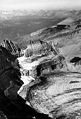
The key symptom of a glacier in disequilibrium is thinning along the entire length of the glacier. This indicates thinning in the accumulation zone. The result is marginal recession of the accumulation zone margin, not just of the terminus. In effect, the glacier no longer has a consistent accumulation zone.Template:Ref harvTemplate:Ref harv For example, Easton Glacier (see below) will likely shrink to half its size, but at a slowing rate of reduction, and stabilize at that size, despite the warmer temperature, over a few decades. However, the Grinnell Glacier (pictured above) will shrink at an increasing rate until it disappears. The difference is that the upper section of Easton Glacier remains healthy and snow covered, while even the upper section of the Grinnell Glacier is bare, is melting and has thinned. Small glaciers with minimal altitude range are most likely to fall into disequilibrium with the climate.
Methods for measuring glacier retreat include staking terminus location, global positioning mapping, aerial mapping, and laser altimetry.
Mid-latitude glaciers
Mid-latitude glaciers are located either between the Tropic of Cancer and the Arctic Circle, or between the Tropic of Capricorn and the Antarctic Circle. These two regions support glacier ice from mountain glaciers, valley glaciers and even smaller icecaps, which are usually located in higher mountainous regions. All of these glaciers are located in mountain ranges, notably the Himalayas; the Alps; the Pyrenees; Rocky Mountains and Pacific Coast Ranges of North America; the Patagonian Andes in South America; and mountain ranges in New Zealand. Glaciers in these latitudes are more widespread and tend to be more massive the closer they are located to the polar regions. These glaciers are the most widely studied over the past 150 years. As is true with the glaciers located in the tropical zone, virtually all the glaciers in the mid-latitudes are in a state of negative mass balance and are retreating.
Eastern hemisphere

Europe
The World Glacier Monitoring Service reports on changes in the terminus, or lower elevation end, of glaciers from around the world every five years.Template:Ref harv In their 2000-2005 edition, they noted the terminal point variations of glaciers across the Alps. Over the five-year period from 2000-2005, 115 of 115 glaciers examined in Switzerlandretreated, 115 of 115 glaciers in Austria reatreated, in Italy during 2005 50 glaciers were retreating and 3 stationary , and all 7 glaciers observed in France were in retreat. French glaciers experienced a sharp retreat in the years 1942–53 followed by advances up to 1980, and then further retreat beginning in 1982. As an example, since 1870 the Argentière Glacier and Mont Blanc Glacier have receded by 1,150 m (3,770 ft) and 1,400 m (4,600 ft), respectively. The largest glacier in France, the Mer de Glace, which is 11 km (6.8 mi) long and 400 m (1,300 ft) thick, has lost 8.3% of its length, or 1 km (0.62 mi), in 130 years, and thinned by 27%, or 150 m (490 ft), in the midsection of the glacier since 1907. The Bossons Glacier in Chamonix, France, has retreated 1,200 m (3,900 ft) from extents observed in the early 20th century. In 2005, of 91 Swiss glaciers studied, 84 retreated from where their terminal points had been in 2004 while the remaining 7 showed no change.Template:Ref harv
Other researchers have found that glaciers across the Alps appear to be retreating at a faster rate than a few decades ago. In 2008, the Swiss Glacier survey of 85 glaciers found 78 retreating, 2 stationary and 5 advancing. The Trift Glacier had retreated over 500 m (1,600 ft) just in the three years of 2003 to 2005, which is 10% of its total length. The Grosser Aletsch Glacier, the largest glacier in Switzerland, has retreated 2,600 m (8,500 ft) since 1880. This rate of retreat has also increased since 1980, with 30%, or 800 m (2,600 ft), of the total retreat occurring in the last 20% of the time period.Template:Ref harv Similarly, of the glaciers in the Italian Alps, only about a third were in retreat in 1980, while by 1999, 89% of these glaciers were retreating. In 2005, the Italian Glacier Commission found that 123 glaciers were retreating, 1 advancing and 6 stationary.Template:Ref harv Repeat photography of glaciers in the Alps provides clear evidence that glaciers in this region have retreated significantly in the past several decades. Template:Ref harv Morteratsch Glacier, Switzerland is one key example. The yearly measurements of the length changes started in 1878. The overall retreat from 1878 to 1998 has been 2 km (1.2 mi) with a mean annual retreat rate of approximately 17 m (56 ft) per year. This long-term average was markedly surpassed in recent years with the glacier receding 30 m (98 ft) per year during the period between 1999–2005.Template:Ref harv One major concern which has in the past had great impact on lives and property is the death and destruction from a Glacial Lake Outburst Flood (GLOF). Glaciers stockpile rock and soil that has been carved from mountainsides at their terminal end. These debris piles often form dams that impound water behind them and form glacial lakes as the glaciers melt and retreat from their maximum extents. These terminal moraines are frequently unstable and have been known to burst if overfilled or displaced by earthquakes, landslides or avalanches. If a glacier has a rapid melting cycle during warmer months, the terminal moraine may not be strong enough to hold the rising water behind it, leading to a massive localized flood. This is an increasing risk due to the creation and expansion of glacial lakes resulting from glacier retreat. Past floods have been deadly and have resulted in enormous property damage. Towns and villages in steep, narrow valleys that are downstream from glacial lakes are at the greatest risk. In 1892 a GLOF released some 200,000 km3 (2.6×10¹⁴ cu yd) of water from the lake of the Glacier de Tête Rousse, resulting in the deaths of 200 people in the French town of Saint Gervais.Template:Ref harv GLOFs have been known to occur in every region of the world where glaciers are located. Continued glacier retreat is expected to create and expand glacial lakes, increasing the danger of future GLOFs.
Though the glaciers of the Alps have received more attention from glaciologists than in other areas of Europe, research indicates that throughout most of Europe, glaciers are rapidly retreating. In the Kebnekaise Mountains of northern Sweden, a study of 16 glaciers between 1990 and 2001 found that 14 glaciers were retreating, one was advancing and one was stable.Template:Ref harv During the 20th century, glaciers in Norway retreated overall with brief periods of advance around 1910, 1925 and in the 1990s. In the 1990s, 11 of 25 Norwegian glaciers observed had advanced due to several consecutive winters with above normal precipitation. However, following several consecutive years of little winter precipitation since 2000, and record warmth during the summers of 2002 and 2003, Norwegian glaciers have decreased significantly since the 1990s. By 2005 only 1 of the 25 glaciers monitored in Norway was advancing, two were stationary and 22 were retreating. In 2009 18 glaciers reatreated, three were stationary (less than 2 meters of change) and two advanced. In 2006 glacier mass balances were very negative in Norway and of the 26 glaciers examined, 24 were retreating with one stationary and one advancing.Template:Ref harv The Norwegian Engabreen Glacier has retreated 185 m (607 ft) since 1999, while the Brenndalsbreen and Rembesdalsskåka glaciers have retreated 276 m (906 ft) and 250 m (820 ft), respectively, since 2000. The Briksdalsbreen glacier retreated 96 m (315 ft) in 2004 alone—the largest annual retreat recorded for this glacier since monitoring began in 1900. This figure was exceeded in 2006 with five glaciers retreating over 100 m (330 ft) from the fall of 2005 to the fall of 2006. Four outlets from the Jostedalsbreen ice cap, Kjenndalsbreen, Brenndalsbreen, Briksdalsbreen and Bergsetbreen had a frontal retreat of more than 100 metres. Gråfjellsbrea, an outlet from Folgefonna, had a retreat of almost 100 m (330 ft). Overall, from 1999 to 2005, Briksdalsbreen retreated 336 metres (1,102 ft).Template:Ref harv.
In the Spanish Pyrenees, recent studies have shown important losses in extent and volume of the glaciers of the Maladeta massif during the period 1981-2005. These include a reduction in area of 35.7%, from 2.41 km2 (600 acres) to .627 km2 (155 acres), a loss in total ice volume of .0137 km3 (0.0033 cu mi) and an increase in the mean altitude of the glacial termini of 43.5 m (143 ft).Template:Ref harv For the Pyrenees as a whole 50-60% of the glaciated area has been lost since 1991. At least three glaciers Balaitus, Perdigurero and La Munia have disappeared in this period. Peridido Glacier has shrank from 90 hectares to 40 hectares. Template:Ref harv
Siberia
Siberia and the Russian Far East, although typically classified as polar regions, owing to the dryness of the winter climate have glaciers only in the high Altai Mountains, Verkhoyansk Range and Cherskiy Range. Kamchatka, exposed to moisture form the Sea of Okhotsk, has much more extensive glaciation totaling around 2,500 square kilometres (970 square miles).
Because the collapse of Communism has caused a large reduction in the number of monitoring stations[1], details on the retreat of Siberian glaciers is much poorer than in most other regions of the world. Nonetheless, available records do indicate a general retreat of all glaciers in the Altai Mountains and (with the exception of volcanic glaciers) in Kamchatka. Sakha's glaciers, totaling seventy square kilometers, have shrunk by around 28 percent since 1945[2], whilst in moister regions of Siberia and on the Pacific coast, the shrinkage is considerably larger[3], reaching several percent annually in some places.
Asia

The Himalayas and other mountain chains of central Asia support large regions that are glaciated. These glaciers provide critical water supplies to arid countries such as Mongolia, western China, Pakistan and Afghanistan. As is true with other glaciers worldwide, the glaciers of Asia are experiencing a rapid decline in mass. The loss of these glaciers would have a tremendous impact on the ecosystem of the region.
In the Wakhan Corridor of Afghanistan 28 of 30 glaciers examined retreated significantly during the 1976-2003 period, the average retreat was 11 meters per year Template:Ref harv. One of these glaciers the Zemestan Glacier has retreated 460 m during this period, not quite 10% of its 5.2 km length.Template:Ref harv In examining 612 glaciers in China between 1950 and 1970, 53% of the glaciers studied were retreating. After 1990, 95% of these glaciers were measured to be retreating, indicating that retreat of these glaciers was becoming more widespread.Template:Ref harv Glaciers in the Mount Everest region of the Himalayas are all in a state of retreat. The Rongbuk Glacier, draining the north side of Mount Everest into Tibet, has been retreating 20 m (66 ft) per year. In the Khumbu region of Nepal along the front of the main Himalaya of 15 glaciers examined from 1976-2007 all retreated significantly, average retreat was 28 m per year Template:Ref harv. The most famous of these Khumbu Glacier retreated at a rate of 18 m per year from 1976-2007Template:Ref harv. In India the Gangotri Glacier, which is a significant source of water for the Ganges River, retreated 34 m (112 ft) per year between 1970 and 1996, and has averaged a loss of 30 m (98 ft) per year since 2000. However, the glacier is still over 30 km (19 mi) long. For the Indian Himalaya retreat ranged from -19 meters per year for 17 glaciers all retreating Template:Ref harv. In Sikkim all 21 glaciers examined were retreating at an average rate of 20 m per year Template:Ref harv. For the 51 glaciers in the main Himalayan Range of India, Nepal and Sikkim all 51 are retreating, at an average rate of 23 m per year. In the Karokoram Range of the Himalaya there is a mix of advancing and retreating glaciers with 18 advancing and 22 retreating during the 1980-2003 period. Template:Ref harv
With the retreat of glaciers in the Himalayas, a number of glacial lakes have been created. A growing concern is the potential for Glacial Lake Outburst Floods—researchers estimate 20 glacial lakes in Nepal and 24 in Bhutan pose hazards to human populations should their terminal moraine dams fail. One glacial lake identified as potentially hazardous is Bhutan's Raphstreng Tsho, which measured 1.6 km (0.99 mi) long, .96 m (0.00096 km) wide and was 80 m (260 ft) deep in 1986. By 1995 the lake had swollen to a length of 1.94 km (1.21 mi), 1.13 km (0.70 mi) in width and a depth of 107 m (351 ft). In 1994 a GLOF from Luggye Tsho, a glacial lake adjacent to Raphstreng Tsho, killed 23 people downstream.Template:Ref harv
Glaciers in the Ak-shirak Range in Kyrgyzstan experienced a slight loss between 1943 and 1977 and an accelerated loss of 20% of their remaining mass between 1977 and 2001.Template:Ref harv In the Tien Shan mountains, which Kyrgyzstan shares with China and Kazakhstan, studies in the northern areas of that mountain range show that the glaciers that help supply water to this arid region have been losing nearly 2 km3 (0.48 cu mi) of ice per year between 1955 and 2000. The University of Oxford study also reported that an average of 1.28% of the volume of these glaciers had been lost per year between 1974 and 1990.Template:Ref harv
To the south of the Tien Shan, the Pamirs mountain range located primarily in Tajikistan has many thousands of glaciers, all of which are in a general state of retreat. During the 20th century, the glaciers of Tajikistan lost 20 km3 (4.8 cu mi) of ice. The 70 km (43 mi) long Fedchenko Glacier, which is the largest in Tajikistan and the largest non-polar glacier on Earth, lost 1.4% of its length, or 1 km (0.62 mi), 2 km3 (0.48 cu mi) of its mass, and the glaciated area was reduced by 11 km2 (4.2 sq mi) during the 20th century. Similarly, the neighboring Skogatch Glacier lost 8% of its total mass between 1969 and 1986. The country of Tajikistan and neighboring countries of the Pamir Range are highly dependent upon glacial runoff to ensure river flow during droughts and the dry seasons experienced every year. The continued demise of glacier ice will result in a short-term increase, followed by a long-term decrease in glacial melt water flowing into rivers and streams.Template:Ref harv
The Tibetan Plateau contains the world's third-largest store of ice. Qin Dahe, the former head of the China Meteorological Administration, said that the recent fast pace of melting and warmer temperatures will be good for agriculture and tourism in the short term; but issued a strong warning:
"Temperatures are rising four times faster than elsewhere in China, and the Tibetan glaciers are retreating at a higher speed than in any other part of the world.... In the short term, this will cause lakes to expand and bring floods and mudflows. . . . In the long run, the glaciers are vital lifelines for Asian rivers, including the Indus and the Ganges. Once they vanish, water supplies in those regions will be in peril."[4]
Oceania

In New Zealand the mountain glaciers have been in general retreat since 1890, with an acceleration of this retreat since 1920. Most of the glaciers have thinned measurably and have reduced in size, and the snow accumulation zones have risen in elevation as the 20th century progressed. During the period 1971–75, Ivory Glacier receded 30 m (98 ft) from the glacial terminus, and about 26% of the surface area of the glacier was lost over the same period. Since 1980 numerous small glacial lakes were created behind the new terminal moraines of several of these glaciers. Glaciers such as Classen, Godley and Douglas now all have new glacial lakes below their terminal locations due to the glacial retreat over the past 20 years. Satellite imagery indicates that these lakes are continuing to expand. There has been significant and ongoing ice volume losses on the largest New Zealand glaciers, including the Tasman, Ivory, Classen, Mueller, Maud, Hooker, Grey, Godley, Ramsay, Murchison, Therma, Volta and Douglas Glaciers. The retreat of these glaciers has been marked by expanding proglacial lakes and terminus region thinning. The loss in volume from 1975-2005 is 11% of the total.Template:Ref harv
Several glaciers, notably the much visited Fox and Franz Josef Glaciers on New Zealand's West Coast, have periodically advanced, especially during the 1990s, but the scale of these advances is small when compared to 20th-century retreat. Both glaciers are currently more than 2.5 km (1.6 mi) shorter than a century ago. These large, rapidly flowing glaciers situated on steep slopes have been very reactive to small mass-balance changes. A few years of conditions favorable to glacier advance, such as more westerly winds and a resulting increase in snowfall, are rapidly echoed in a corresponding advance, followed by equally rapid retreat when those favorable conditions end.Template:Ref harv The glaciers that have been advancing in a few locations in New Zealand have been doing so due to a temporary weather change associated with El Niño, which has brought more precipitation and cloudier, cooler summers since 2002.Template:Ref harv
Western hemisphere

North American glaciers are primarily located along the spine of the Rocky Mountains in the United States and Canada, and the Pacific Coast Ranges extending from northern California to Alaska. While Greenland is geologically associated with North America, it is also a part of the Arctic region. Apart from the few tidewater glaciers such as Taku Glacier, that are in the advance stage of their tidewater glacier cycle prevalent along the coast of Alaska, virtually all the glaciers of North America are in a state of retreat. The observed retreat rate has increased rapidly since approximately 1980, and overall each decade since has seen greater rates of retreat than the preceding one. There are also small remnant glaciers scattered throughout the Sierra Nevada mountains of California and Nevada.
Cascades
The Cascade Range of western North America extends from southern British Columbia in Canada to northern California. Excepting Alaska, about half of the glacial area in the U.S. is contained in the more than 700 glaciers of the North Cascades, a portion of the range between the Canadian border and I-90 in central Washington. These glaciers store as much water as that contained in all the lakes and reservoirs in the rest of the state, and provide much of the stream and river flow in the dry summer months, approximating some 870,000 m3 (1,140,000 cu yd).


As recently as 1975, many North Cascade glaciers were advancing due to cooler weather and increased precipitation that occurred from 1944 to 1976. However, by 1987 all the North Cascade glaciers were retreating, and the pace of the glacier retreat has increased each decade since the mid-1970s. Between 1984 and 2005, the North Cascade glaciers lost an average of more than 12.5 m in thickness and between 20% and 40% of their volume.Template:Ref harv
Glaciologists researching the North Cascades glaciers have found that all 47 monitored glaciers are receding and that four glaciers—Spider Glacier, Lewis Glacier (pictured), Milk Lake Glacier, and David Glacier—have disappeared completely since 1985. The White Chuck Glacier (near Glacier Peak) is a particularly dramatic example. The glacier area shrank from 3.1 km2 (1.2 sq mi) in 1958 to .9 km2 (0.35 sq mi) by 2002. Between 1850 and 1950, the Boulder Glacier on the southeast flank of Mount Baker retreated 8,700 feet (2,650 m). William Long of the United States Forest Service observed the glacier beginning to advance due to cooler/wetter weather in 1953. This was followed by a 2,438 feet (743 m) advance by 1979.Template:Ref harv The glacier again retreated 450 m (1,480 ft) from 1987 to 2005, leaving barren terrain behind. This retreat has occurred during a period of reduced winter snowfall and higher summer temperatures. In this region of the Cascades, winter snowpack has declined 25% since 1946, and summer temperatures have risen 0.7 °C (1.2 °F) during the same period. The reduced snowpack has occurred despite a small increase in winter precipitation; thus, it reflects warmer winter temperatures leading to rainfall and melting on glaciers even during the winter. As of 2005, 67% of the North Cascade glaciers observed are in disequilibrium and will not survive the continuation of the present climate. These glaciers will eventually disappear unless temperatures fall and frozen precipitation increases. The remaining glaciers are expected to stabilize, unless the climate continues to warm, but will be much reduced in size.Template:Ref harvTemplate:Ref harv
US Rocky Mountains
On the sheltered slopes of the highest peaks of Glacier National Park in Montana, its eponymous glaciers are diminishing rapidly. The area of each glacier has been mapped by the National Park Service and the U.S. Geological Survey for decades. Comparing photographs taken in the mid-19th century with contemporary images provides ample evidence that the glaciers in the park have retreated notably since 1850. Repeat photography over the decades since clearly show that glaciers throughout the park such as Grinnell Glacier are all retreating. The larger glaciers are now approximately a third of their former size when first studied in 1850, and numerous smaller glaciers have disappeared completely. Only 27% of the 99 km2 (38 sq mi) area of Glacier National Park covered by glaciers in 1850 remained covered by 1993. Template:Ref harv Researchers believe that by the year 2030, the vast majority of glacial ice in Glacier National Park will be gone unless current climate patterns reverse their course.Template:Ref harv Grinnell Glacier is just one of many glaciers in Glacier National Park that have been well documented by photographs for many decades. The photographs below clearly demonstrate the retreat of this glacier since 1938.
-
 1938 T.J. Hileman GNP
 -
 1981 Carl Key (USGS)
 -
 1998 Dan Fagre (USGS)
 -
 2005 Blase Reardon (USGS)


The semiarid climate of Wyoming still manages to support about a dozen small glaciers within Grand Teton National Park, which all show evidence of retreat over the past 50 years. Schoolroom Glacier, located slightly southwest of Grand Teton, one of the more easily reached glaciers in the park, is expected to disappear by 2025.[dead link]Template:Ref harv Research between 1950 and 1999 demonstrated that the glaciers in Bridger-Teton National Forest and Shoshone National Forest in the Wind River Range shrank by over a third of their size during that period. Photographs indicate that the glaciers today are only half the size as when first photographed in the late 1890s. Research also indicates that the glacial retreat was proportionately greater in the 1990s than in any other decade over the last 100 years. Gannett Glacier on the northeast slope of Gannett Peak is the largest single glacier in the Rocky Mountains south of Canada. It has reportedly lost over 50% of its volume since 1920, with almost half of that loss occurring since 1980. Glaciologists believe the remaining glaciers in Wyoming will disappear by the middle of the 21st century if the current climate patterns continue.Template:Ref harv
Canadian Rockies


In the Canadian Rockies, the glaciers are generally larger and more widespread than they are to the south in the United States Rocky Mountains. One of the more accessible glaciers in the Canadian Rockies is the Athabasca Glacier, which is an outlet glacier of the 325 km2 (125 sq mi) Columbia Icefield. The Athabasca Glacier has retreated 1,500 m (4,900 ft) since the late 19th century. The rate of retreat for this glacier has increased since 1980, following a period of slow retreat from 1950 to 1980. The Peyto Glacier in Alberta covers an area of about 12 km2 (4.6 sq mi), and retreated rapidly during the first half of the 20th century, stabilized by 1966, and resumed shrinking in 1976.Template:Ref harv Illecillewaet Glacier in British Columbia's Glacier National Park (Canada) has retreated 2 km (1.2 mi) since first photographed in 1887.
Alaska
There are thousands of glaciers in Alaska, though only a relative few of them have been named. The Columbia Glacier near Valdez in Prince William Sound has retreated 15 km (9.3 mi) in the last 25 years. Icebergs calved off this glacier were a partial cause of the Exxon Valdez oil spill, as the oil tanker had changed course to avoid the icebergs. The Valdez Glacier is in the same area, and though it does not calve, it has also retreated significantly. "A 2005 aerial survey of Alaskan coastal glaciers identified more than a dozen glaciers, many former tidewater and calving glaciers, including Grand Plateau, Alsek, Bear, and Excelsior Glaciers that are rapidly retreating. Of 2,000 glaciers observed, 99% are retreating." Template:Ref harv Icy Bay in Alaska is fed by three large glaciers—Guyot, Yahtse, and Tyndall Glaciers—all of which have experienced a loss in length and thickness and, consequently, a loss in area. Tyndall Glacier became separated from the retreating Guyot Glacier in the 1960s and has retreated 24 km (15 mi) since, averaging more than 500 m (1,600 ft) per year.Template:Ref harv
The Juneau Icefield Research Program has monitored the outlet glaciers of the Juneau Icefield since 1946. On the west side of the ice field, the terminus of the Mendenhall Glacier, which flows into suburban Juneau, Alaska, has retreated 580 m (1,900 ft). Of the nineteen glaciers of the Juneau Icefield, eighteen are retreating, and one, the Taku Glacier, is advancing. Eleven of the glaciers have retreated more than 1 km (0.62 mi) since 1948 — Antler Glacier, 5.4 km (3.4 mi); Gilkey Glacier, 3.5 km (2.2 mi); Norris Glacier, 1.1 km (0.68 mi) and Lemon Creek Glacier, 1.5 km (0.93 mi).Template:Ref harv Taku Glacier has been advancing since at least 1890, when naturalist John Muir observed a large iceberg calving front. By 1948 the adjacent fjord had filled in, and the glacier no longer calved and was able to continue its advance. By 2005 the glacier was only 1.5 km (0.93 mi) from reaching Taku Point and blocking Taku Inlet. The advance of Taku Glacier averaged 17 m (56 ft) per year between 1988 and 2005. The mass balance was very positive for the 1946–88 period fueling the advance; however, since 1988 the mass balance has been slightly negative, which should in the future slow the advance of this mighty glacier.[dead link]Template:Ref harv
Long-term mass balance records from Lemon Creek Glacier in Alaska show slightly declining mass balance with time.Template:Ref harv The mean annual balance for this glacier was −0.23 m (0.75 ft) each year during the period of 1957 to 1976. Mean annual balance has been increasingly negatively averaging −1.04 m (3.4 ft) per year from 1990 to 2005. Repeat glacier altimetry, or altitude measuring, for 67 Alaska glaciers find rates of thinning have increased by more than a factor of two when comparing the periods from 1950 to 1995 (0.7 m (2.3 ft) per year) and 1995 to 2001 (1.8 m (5.9 ft) per year).Template:Ref harv This is a systemic trend with loss in mass equating to loss in thickness, which leads to increasing retreat—the glaciers are not only retreating, but they are also becoming much thinner. In Denali National Park, all glaciers monitored are retreating, with an average retreat of 20 m (66 ft) per year. The terminus of the Toklat Glacier has been retreating 26 m (85 ft) per year and the Muldrow Glacier has thinned 20 m (66 ft) since 1979.Template:Ref harv Well documented in Alaska are surging glaciers that have been known to rapidly advance, even as much as 100 m (330 ft) per day, though the reasons they do this is not fully understood. Template:Ref harv Variegated, Black Rapids, Muldrow, Susitna and Yanert are examples of surging glaciers in Alaska that have made rapid advances in the past. These glaciers are all retreating overall, punctuated by short periods of advance.
Andes and Tierra del Fuego

A large region of population surrounding the central and southern Andes of Argentina and Chile reside in arid areas that are dependent on water supplies from melting glaciers. The water from the glaciers also supplies rivers that have in some cases been dammed for hydroelectric power. Some researchers believe that by 2030, many of the large ice caps on the highest Andes will be gone if current climate trends continue. In Patagonia on the southern tip of the continent, the large ice caps have retreated a 1 km (0.62 mi) since the early 1990s and 10 km (6.2 mi) since the late 1800s. It has also been observed that Patagonian glaciers are receding at a faster rate than in any other world region.Template:Ref harv The Northern Patagonian Ice Field lost 93 km2 (36 sq mi) of glacier area during the years between 1945 and 1975, and 174 km2 (67 sq mi) from 1975 to 1996, which indicates that the rate of retreat is increasing. This represents a loss of 8% of the ice field, with all glaciers experiencing significant retreat. The Southern Patagonian Ice Field has exhibited a general trend of retreat on 42 glaciers, while four glaciers were in equilibrium and two advanced during the years between 1944 and 1986. The largest retreat was on O'Higgins Glacier, which during the period 1896–1995 retreated 14.6 km (9.1 mi). The Perito Moreno Glacier is 30 km (19 mi) long and is a major outflow glacier of the Patagonian ice sheet, as well as the most visited glacier in Patagonia. Perito Moreno Glacier is presently in equilibrium, but has undergone frequent oscillations in the period 1947–96, with a net gain of 4.1 km (2.5 mi). This glacier has advanced since 1947, and has been essentially stable since 1992. Perito Moreno Glacier is one of three glaciers in Patagonia known to have advanced, compared to several hundred others in retreat.Template:Ref harvTemplate:Ref harv. The two major glaciers of the Southern Patagonia Icefield to the north of Moreno, Upsala and Videma Glacier have retreated 4.6 km (2.9 mi) in 21 years and 1 km (0.62 mi) in 13 years respectively Template:Ref harv. In the Aconcagua River Basin, glacier retreat has resulted in a 20% loss in glacier area, declining from 151 km2 (58 sq mi) to 121 km2 (47 sq mi).Template:Ref harv The Marinelli Glacier in Tierra del Fuego has been in retreat since at least 1960 through 2008.
Tropical glaciers
Tropical glaciers are located between the Tropic of Cancer and the Tropic of Capricorn, in the region that lies 23° 26′ 22″ north or south of the equator. Tropical glaciers are the most uncommon of all glaciers for a variety of reasons. Firstly, the tropics are the warmest part of the planet. Secondly, the seasonal change is minimal with temperatures warm year round, resulting in a lack of a colder winter season in which snow and ice can accumulate. Thirdly, few taller mountains exist in these regions upon which enough cold air exists for the establishment of glaciers. All of the glaciers located in the tropics are on isolated high mountain peaks. Overall, tropical glaciers are smaller than those found elsewhere and are the most likely glaciers to show rapid response to changing climate patterns. A small temperature increase of only a few degrees can have almost immediate and adverse impact on tropical glaciers.Template:Ref harv
Africa

With almost the entire continent of Africa located in the tropical and subtropical climate zones, glaciers are restricted to two isolated peaks and the Ruwenzori Range. Kilimanjaro, at 5,895 m (19,341 ft), is the highest peak on the continent. Since 1912 the glacier cover on the summit of Kilimanjaro has apparently retreated 75%, and the volume of glacial ice is now 80% less than it was a century ago due to both retreat and thinning.Template:Ref harv In the 14-year period from 1984 to 1998, one section of the glacier atop the mountain receded 300 m (980 ft).Template:Ref harv A 2002 study determined that if current conditions continue, the glaciers atop Kilimanjaro will disappear sometime between 2015 and 2020.Template:Ref harvTemplate:Ref harv A March 2005 report indicated that there is almost no remaining glacial ice on the mountain, and it is the first time in 11,000 years that barren ground has been exposed on portions of the summit.Template:Ref harvTemplate:Ref harv Researchers reported Kilimanjaro's glacier retreat was due to a combination of increased sublimation and decreased snow fall.Template:Ref harv
The Furtwängler Glacier is located near the summit of Kilimanjaro. Between 1976 and 2000, the area of Furtwängler Glacier was cut almost in half, from 113,000 m2 (1,220,000 sq ft) to 60,000 m2 (650,000 sq ft).Template:Ref harv During fieldwork conducted early in 2006, scientists discovered a large hole near the center of the glacier. This hole, extending through the 6 m (20 ft) remaining thickness of the glacier to the underlying rock, is expected to grow and split the glacier in two by 2007.Template:Ref harv
To the north of Kilimanjaro lies Mount Kenya, which at 5,199 m (17,057 ft) is the second tallest mountain on the African continent. Mount Kenya has a number of small glaciers that have lost at least 45% of their mass since the middle of the 20th century. According to research compiled by the U.S. Geological Survey (USGS), there were eighteen glaciers atop Mount Kenya in 1900, and by 1986 only eleven remained. The total area covered by glaciers was 1.6 km2 (0.62 sq mi) in 1900, however by the year 2000 only about 25%, or 0.4 km2 (0.15 sq mi) remained.Template:Ref harv To the west of Mounts Kilimanjaro and Kenya, the Ruwenzori Range rises to 5,109 m (16,762 ft). Photographic evidence of this mountain range indicates a marked reduction in glacially covered areas over the past century. In the 35-year period between 1955 and 1990, glaciers on the Ruwenzori Range receded about 40%. It is expected that due to their proximity to the heavy moisture of the Congo region, the glaciers in the Ruwenzori Range may recede at a slower rate than those on Kilimanjaro or in Kenya.Template:Ref harv
South America
A study by glaciologists of two small glaciers in South America reveals another retreat. More than 80% of all glacial ice in the northern Andes is concentrated on the highest peaks in small glaciers of approximately 1 km2 (0.39 sq mi) in size. A 1992 to 1998 observation of the Chacaltaya Glacier in Bolivia and Antizana Glacier in Ecuador indicated that between 0.6 m (2.0 ft) and 1.9 m (6.2 ft) of ice was lost per year on each glacier. Figures for Chacaltaya Glacier show a loss of 67% of its volume and 40% of its thickness over the same period. Chacaltaya Glacier has lost 90% of its mass since 1940 and is expected to disappear altogether sometime between 2010 and 2015. Research also indicates that since the mid-1980s, the rate of retreat for both of these glaciers has been increasing.Template:Ref harv In Colombia, the glaciers atop Nevado del Ruiz have lost more than half their area in the last 40 years.Template:Ref harv Further south in Peru, the Andes are at a higher altitude overall, and there are approximately 722 glaciers covering an area of 723 km2 (279 sq mi). Research in this region of the Andes is less extensive but indicates an overall glacial retreat of 7% between 1977 and 1983.Template:Ref harv The Quelccaya Ice Cap is the largest tropical icecap in the world, and all of the outlet glaciers from the icecap are retreating. In the case of Qori Kalis Glacier, which is Quelccayas' main outlet glacier, the rate of retreat had reached 155 m (509 ft) per year during the three year period of 1995 to 1998. The melting ice has formed a large lake at the front of the glacier since 1983, and bare ground has been exposed for the first time in thousands of years.Template:Ref harv
Oceania


On the large island of New Guinea, there is photographic evidence of massive glacial retreat since the region was first extensively explored by airplane in the early 1930s. Due to the location of the island within the tropical zone, there is little to no seasonal variation in temperature. The tropical location has a predictably steady level of rain and snowfall, as well as cloud cover year round, and there has been no noticeable change in the amount of moisture which has fallen during the 20th century. The 7 km2 (2.7 sq mi) ice cap on Puncak Jaya is the largest on the island, and has retreated from one larger mass into several smaller glacial bodies since 1936. Of these smaller glaciers, research between 1973 and 1976 showed glacier retreat for the Meren Glacier of 200 m (660 ft) while the Carstensz Glacier lost 50 m (160 ft). The Northwall Firn, another large remnant of the icecap that once was atop Puncak Jaya, has itself split into several separate glaciers since 1936. Research presented in 2004 of IKONOS satellite imagery of the New Guinean glaciers provided a dramatic update. The imagery indicated that in the two years from 2000 to 2002, the East Northwall Firn had lost 4.5%, the West Northwall Firn 19.4% and the Carstensz 6.8% of their glacial mass. Researchers also discovered that, sometime between 1994 and 2000, the Meren Glacier disappeared altogether.Template:Ref harv Separate from the glaciers of Puncak Jaya, another small icecap known to have existed on the summit of Puncak Trikora completely disappeared sometime between 1939 and 1962.Template:Ref harv
Polar regions
Despite their proximity and importance to human populations, the mountain and valley glaciers of tropical and mid-latitude glaciers amount to only a small fraction of glacial ice on the Earth. About 99% of all freshwater ice is in the great ice sheets of polar and subpolar Antarctica and Greenland. These continuous continental-scale ice sheets, 3 km (1.9 mi) or more in thickness, cap much of the polar and subpolar land masses. Like rivers flowing from an enormous lake, numerous outlet glaciers transport ice from the margins of the ice sheet to the ocean.
Iceland
The northern Atlantic island nation of Iceland is home to the Vatnajökull, which is the largest ice cap in Europe. The Breiðamerkurjökull Glacier is one of the Vatnajökull outlet glaciers, and had receded by as much as 2 km (1.2 mi) between 1973 and 2004. In the early 20th century, Breiðamerkurjökull extended to within 250 m (820 ft) of the ocean, but by 2004 Breiðamerkurjökull's terminus had retreated 3 km (1.9 mi) further inland. This glacier retreat exposed a rapidly expanding lagoon that is filled with icebergs calved from its front. The lagoon is 110 m (360 ft) deep and nearly doubled its size between 1994 and 2004. Mass-balance measurements of Iceland's glaciers show alternating positive and negative mass balance of glaciers during the period 1987–95, but the mass balance has been predominantly negative since. On Hofsjokull ice cap, mass balance has been negative each year from 1995-2005.
Most of the Icelandic glaciers retreated rapidly during the warm decades from 1930 to 1960, slowing down as the climate cooled during the following decade, and started to advance after 1970. The rate of advance peaked in the 1980s, after which it slowed down as a consequence of rapid warming of the climate that has taken place since the mid-1980s. Most glaciers in Iceland began to retreat after 1990, and by 2000 all monitored non-surge type glaciers in Iceland were retreating. An average of 45 non-surging termini were monitored each year by the Icelandic Glaciological Society from 2000-2005.Template:Ref harv
Canada

The Canadian Arctic islands have a number of substantial ice caps, including Penny and Barnes Ice Cap on Baffin Island, Bylot Ice Cap on Bylot Island, and Devon Ice Cap on Devon Island. All of these ice caps have been thinning and receding slowly. The Barnes and Penny ice caps on Baffin Island have been thinning at over 1 m (3.3 ft) per year in the lower elevations from 1995 to 2000. Overall, between 1995 and 2000, ice caps in the Canadian Arctic lost 25 km2 (9.7 sq mi) of ice per year.Template:Ref harv Between 1960 and 1999, the Devon Ice Cap lost 67 km3 (16 cu mi) of ice, mainly through thinning. All major outlet glaciers along the eastern Devon Ice Cap margin have retreated from 1 km (0.62 mi) to 3 km (1.9 mi) since 1960.Template:Ref harv On the Hazen Plateau of Ellesmere Island, the Simmon Ice Cap has lost 47% of its area since 1959.Template:Ref harv If the current climatic conditions continue, the remaining glacial ice on the Hazen Plateau will be gone around 2050. On August 13, 2005 the Ayles Ice Shelf broke free from the north coast of Ellesmere Island, the 66 km2 (25 sq mi) ice shelf drifted into the Arctic Ocean.Template:Ref harv. This followed the splitting of the Ward Hunt Ice Shelf in 2002. The Ward Hunt has lost 90% of its area in the last century.Template:Ref harv
Northern Europe
Arctic islands north of Norway, Finland and Russia have all shown evidence of glacier retreat. In the Svalbard archipelago, the island of Spitsbergen has numerous glaciers. Research indicates that Hansbreen (Hans Glacier) on Spitsbergen retreated 1.4 km (0.87 mi) from 1936 to 1982 and another 400 m (1,300 ft) during the 16-year period from 1982 to 1998.Template:Ref harv Blomstrandbreen, a glacier in the King's Bay area of Spitsbergen, has retreated approximately 2 km (1.2 mi) in the past 80 years. Since 1960 the average retreat of Blomstrandbreen has been about 35 m (115 ft) a year, and this average was enhanced due to an accelerated rate of retreat since 1995.Template:Ref harv Similarly, Midre Lovenbreen retreated 200 m (656 ft) between 1977 and 1995.Template:Ref harv In the Novaya Zemlya archipelago north of Russia, research indicates that in 1952 there was 208 km (129 mi) of glacier ice along the coast. By 1993 this had been reduced by 8% to 198 km (123 mi) of glacier coastline.Template:Ref harv
Greenland

In Greenland, glacier retreat has been observed in outlet glaciers, resulting in an increase of the ice flow rate and destabilization of the mass balance of the ice sheet that is their source. The net loss in volume and hence sea level contribution of the Greenland Ice Sheet (GIS) has doubled in recent years from 90 km3 (22 cu mi) to 220 km3 (53 cu mi) per year.Template:Ref harv Researchers also noted that the acceleration was widespread affecting almost all glaciers south of 70 N by 2005. The period since 2000 has brought retreat to several very large glaciers that had long been stable. Three glaciers that have been researched—Helheim Glacier, Kangerdlugssuaq Glacier, and Jakobshavn Isbræ—jointly drain more than 16% of the Greenland Ice Sheet. In the case of Helheim Glacier, researchers used satellite images to determine the movement and retreat of the glacier. Satellite images and aerial photographs from the 1950s and 1970s show that the front of the glacier had remained in the same place for decades. In 2001 the glacier began retreating rapidly, and by 2005 the glacier had retreated a total of 7.2 km (4.5 mi), accelerating from 20 m (66 ft) per day to 35 m (115 ft) per day during that period.Template:Ref harv
Jakobshavn Isbræ in west Greenland, a major outlet glacier of the Greenland Ice Sheet, has been the fastest moving glacier in the world over the past half century. It had been moving continuously at speeds of over 24 m (79 ft) per day with a stable terminus since at least 1950. In 2002 the 12 km (7.5 mi) long floating terminus of the glacier entered a phase of rapid retreat, with the ice front breaking up and the floating terminus disintegrating and accelerating to a retreat rate of over 30 m (98 ft) per day. On a shorter timescale, portions of the main trunk of Kangerdlugssuaq Glacier that were flowing at 15 m (49 ft) per day from 1988 to 2001 were measured to be flowing at 40 m (130 ft) per day in the summer of 2005. Not only has Kangerdlugssuaq retreated, it has also thinned by more than 100 m (330 ft)Template:Ref harv
The rapid thinning, acceleration and retreat of Helheim, Jakobshavns and Kangerdlugssuaq glaciers in Greenland, all in close association with one another, suggests a common triggering mechanism, such as enhanced surface melting due to regional climate warming or a change in forces at the glacier front. The enhanced melting leading to lubrication of the glacier base has been observed to cause a small seasonal velocity increase and the release of meltwater lakes has also led to only small short term accelerations Template:Ref harv. The significant accelerations noted on the three larges glaciers began at the calvining front and propagated inland and are not seasonal nature Template:Ref harv Thus, the primary source of outlet glacier acceleration widely observed on small and large calving glaciers in Greenland is driven by changes in dynamic forces at the glacier front, not enhanced meltwater lubricationn Template:Ref harv. This was termed the Jakobshavns Effect by Terence Hughes at the University of Maine in 1986.Template:Ref harv
Antarctica

The climate of Antarctica is one of intense cold and great aridity. Most of the world's freshwater ice is contained in the great ice sheets that cover the continent of Antarctica. The most dramatic example of glacier retreat on the continent is the loss of large sections of the Larsen Ice Shelf on the Antarctic Peninsula. Ice shelves are not stable when surface melting occurs, and the collapse of Larsen Ice Shelf has been caused by warmer melt season temperatures that have led to surface melting and the formation of shallow ponds of water on the ice shelf. The Larsen Ice Shelf lost 2,500 km2 (970 sq mi) of its area from 1995 to 2001. In a 35-day period beginning on January 31, 2002, about 3,250 km2 (1,250 sq mi) of shelf area disintegrated. The ice shelf is now 40% the size of its previous minimum stable extent.[dead link]Template:Ref harv The recent collapse of Wordie Ice Shelf, Mueller Ice Shelf, Jones Ice Shelf, Larsen-A and Larsen-B Ice Shelf on the Antarctic Peninsula has raised awareness of how dynamic ice shelf systems are. After their loss the reduced buttressing of feeder glaciers has allowed the expected speed-up of inland ice masses after shelf ice break-up. Template:Ref harv. The Wilkins Ice Shelf is another ice shelf that has suffered substantial retreat. The ice shelf had an area of 16,000 km2 (6,200 sq mi) in 1998 when 1,000 km2 (390 sq mi) was lost.Template:Ref harv In 2007 and 2008 significant rifting developed and led to the loss of another 1,400 km2 (540 sq mi) of area. Some of the calving occurred in the Austral winter. The calving seemed to have resulted from preconditioning such as thinning, possibly due to basal melt, as surface melt was not as evident, leading to a reduction in the strength of the pinning point connections. The thinner ice than experienced spreading rifts and breakup Template:Ref harv. This period culminated in the collapse of an ice bridge connecting the main ice shelf to Charcot Island leading to the loss of an additional 700 km2 (270 sq mi) in February-June 2009 Template:Ref harv. Recent studies by the British Antarctic Survey have anticipated a potential breakup of the George VI Ice Shelf due to warming ocean currents resulting from global warming.Template:Ref harv
Pine Island Glacier, an Antarctic outflow glacier that flows into the Amundsen Sea, thinned 3.5 m (11 ft)± 0.9 m (3.0 ft) per year and retreated a total of 5 km (3.1 mi) in 3.8 years. The terminus of the Pine Island Glacier is a floating ice shelf, and the point at which it starts to float retreated 1.2 km (0.75 mi) per year from 1992 to 1996. This glacier drains a substantial portion of the West Antarctic Ice Sheet and along with the neighboring Thwaites Glacier, which has also shown evidence of thinning, has been referred to as the weak underbelly of this ice sheet.Template:Ref harv Additionally, the Dakshin Gangotri Glacier, a small outlet glacier of the Antarctic ice sheet, receded at an average rate of 0.7 m (2.3 ft) per year from 1983 to 2002. On the Antarctic Peninsula, which is the only section of Antarctica that extends well north of the Antarctic Circle, there are hundreds of retreating glaciers. In one study of 244 glaciers on the peninsula, 212 have retreated an average of 600 m (2,000 ft) from where they were when first measured in 1953.Template:Ref harv The greatest retreat was seen in Sjogren Glacier, which is now 13 km (8.1 mi) further inland than where it was in 1953. There are 32 glaciers that were measured to have advanced; however, these glaciers showed only a modest advance averaging 300 m (980 ft) per glacier, which is significantly smaller than the massive retreat observed.Template:Ref harv
Impacts of glacier retreat
The continued retreat of glaciers will have a number of different quantitative impacts. In areas that are heavily dependent on water runoff from glaciers that melt during the warmer summer months, a continuation of the current retreat will eventually deplete the glacial ice and substantially reduce or eliminate runoff. A reduction in runoff will affect the ability to irrigate crops and will reduce summer stream flows necessary to keep dams and reservoirs replenished. This situation is particularly acute for irrigation in South America, where numerous artificial lakes are filled almost exclusively by glacial melt.Template:Ref harv Central Asian countries have also been historically dependent on the seasonal glacier melt water for irrigation and drinking supplies. In Norway, the Alps, and the Pacific Northwest of North America, glacier runoff is important for hydropower.
Some of this retreat has resulted in efforts to slow down the loss of glaciers in the Alps. To retard melting of the glaciers used by certain Austrian ski resorts, portions of the Stubai and Pitztal Glaciers were partially covered with plastic Template:Ref harv. In Switzerland plastic sheeting is also used to reduce the melt of glacial ice used as ski slopes.Template:Ref harv While covering glaciers with plastic sheeting may prove advantageous to ski resorts on a small scale, this practice is not expected to be economically practical on a much larger scale.
Many species of freshwater and saltwater plants and animals are dependent on glacier-fed waters to ensure the cold water habitat to which they have adapted. Some species of freshwater fish need cold water to survive and to reproduce, and this is especially true with salmon and cutthroat trout. Reduced glacial runoff can lead to insufficient stream flow to allow these species to thrive. Alterations to the ocean currents, due to increased freshwater inputs from glacier melt, and the potential alterations to thermohaline circulation of the world's oceans, may impact existing fisheries upon which humans depend as well.
The potential for major sea level rise depends mostly on a significant melting of the polar ice caps of Greenland and Antarctica, as this is where the vast majority of glacial ice is located. If all the ice on the polar ice caps were to melt away, the oceans of the world would rise an estimated 70 m (230 ft). However, with little major melt expected in Antarctica, sea level rise of not more than 0.5 m (1.6 ft) is expected through the 21st century, with an average annual rise of 0.004 m (0.013 ft) per year. Thermal expansion of the world's oceans will contribute, independent of glacial melt, enough to double those figures.Template:Ref harv
References
Cited references
- AAAS News, AAAS (April 21, 2005). "New Study in Science Finds Glaciers in Retreat on Antarctic Peninsula". American Association for the Advancement of Science.
{{cite news}}:|last=has generic name (help) - Abdalati W. Abdalati; et al. (November 20, 2004). "Elevation changes of ice caps in the Canadian Arctic Archipelago (Abstract)". American Geophysical Union. 109 (F04007).
{{cite journal}}: Explicit use of et al. in:|author=(help) - Adema Guy W. Adema; et al. "Melting Denali: Effects of Climate Change on the Glaciers of Denali National Park and Preserve" (PDF). Retrieved September 9, 2007.
{{cite web}}: Explicit use of et al. in:|author=(help) - Alean Jürg Alean, Michael Hambrey. "Ice retreat at high and low altitudes (and associated subpages)". Morteratsch ice retreat. Retrieved May 30, 2006.
- Aleksey Aleksey I. Sharov (2005). "Studying changes of ice coasts in the European Arctic" (PDF). Geo-Marine Letters. 25: 153–166. doi:10.1007/s00367-004-0197-7.
- Allison and Peterson Ian Allison and James A. Peterson. "Glaciers of Irian Jaya, Indonesia and New Zealand". U.S. Geological Survey, U.S.Department of the Interior. Retrieved April 28, 2000.
{{cite web}}: Check date values in:|accessdate=(help) - Arendt, et alia Anthony A. Arendt; et al. (July 19, 2002). "Rapid Wastage of Alaska Glaciers and Their Contribution to Rising Sea Level". Science. 297 (5580): 382–386. doi:10.1126/science.1072497. PMID 12130781.
{{cite journal}}: Explicit use of et al. in:|author=(help) - BAS Pritchard, Hamish (June 5, 2007). "Hundreds of Antarctic Peninsula glaciers accelerating as climate warms". British Antarctic Survey.
- BBC News, BBC (October 9, 2003). "Melting glaciers threaten Peru". BBC News.
{{cite news}}:|last=has generic name (help) - BBC2 News, BBC (April 27, 2004). "Patagonian ice in rapid retreat". BBC News.
{{cite news}}:|last=has generic name (help) - BBC3 News, BBC (April 21, 2005). "Antarctic glaciers show retreat". BBC News.
{{cite news}}:|last=has generic name (help) - Independent Connor, Steve (June 6, 2007). "In Antarctica, proof that action on climate change is more urgent than ever". The Independent.
- Bajracharya Bajracharya, Mool. "Glaciers, glacial lakes and glacial lake outburst floods in the Mount Everest region, Nepal" (PDF). International Centre for Integrated Mountain Development. Retrieved January 10, 2010.
{{cite web}}: line feed character in|title=at position 64 (help)[dead link]Bentley & Hodgson Mike Bentley, Dominic Hodgson. "Millennial-scale variability of George VI Ice Shelf, Antarctic Peninsula". British Antarctic Survey. Retrieved July 23, 2002. - Braun, et alia Braun, Carsten; Hardy, D.R.; and Bradley, R.S. (2004). "Mass balance and area changes of four High Arctic plateau ice caps, 1959–2002" (PDF). Geografiska Annaler. 86 (A): 43–52. doi:10.1111/j.0435-3676.2004.00212.x.
{{cite journal}}: CS1 maint: multiple names: authors list (link) - Brown, Rivera and Acuna Brown, F., Rivera, A., Acuna, C. (2008). "Recent glaciers variations at the Aconcagua Basin, central Chilean Andes" (PDF). Annals of glaciology. 48 (2): 43–48. doi:10.3189/172756408784700572.
{{cite journal}}: CS1 maint: multiple names: authors list (link) - Burgess and Sharpa David O. Burgess and Martin J. Sharpa (2003 (December)). "Recent Changes in Areal Extent of the Devon Ice Cap, Nunavut, Canada". BioOne. 36 (2): 261–271. doi:10.1657/1523-0430(2004)036[0261:RCIAEO]2.0.CO;2.
{{cite journal}}: Check date values in:|year=(help) - Byrd Byrd Polar Research Center, The Ohio State University. "Peru – Quelccaya (1974–1983)". Ice Core Paleoclimatology Research Group. Retrieved February 10, 2006.
- CCIN Canadian Cryospheric Information Network. "Past Variability of Canadian Glaciers". Retrieved February 14, 2006.
- Cassasa Casassa, G., H. Brecher, A. Rivera and M. Aniya, (1997). "A century-long record of glacier O'Higgins, Patagonia". Annals of Glaciology. 24: 106–110. doi:10.1029/GL013i001p00046.
{{cite journal}}: CS1 maint: extra punctuation (link) CS1 maint: multiple names: authors list (link) - Chueca et alia J. Chueca; et al. (2007). "Recent evolution (1981–2005) of the Maladeta glaciers, Pyrenees, Spain: extent and volume losses and their relation with climatic and topographic factors". Journal of Glaciology. 53 (183): 547–557. doi:10.3189/002214307784409342.
{{cite journal}}: Explicit use of et al. in:|author=(help) - CICaER Center for International Climate and Environmental Research. "Major changes in Norway's glaciers". Retrieved May 10, 2005.
- Das S.Das, I, Joughin, M. Behm, I. Howat, M. King, D. Lizarralde, M. Bhatia. "Fracture Propagation to the Base of the Greenland Ice Sheet During Supraglacial Lake Drainage". Retrieved 2009.
{{cite web}}: Check date values in:|accessdate=(help)CS1 maint: multiple names: authors list (link) - Elverhoy Hallgeir Elverhoy. "Glacier length change observations" (web page). Norwegian Water Resources and Energy Directorate. Retrieved 2010-01-09.
- ENN "Glacial Cover-Up Won't Stop Global Warming, But It Keeps Skiers Happy". Environmental News Network. July 15, 2005.
{{cite news}}:|first=missing|last=(help) - EORC "Huge glaciers retreat on a large scale in Patagonia, South America". Earth Observation research Center. July 15, 2005. Retrieved June 13, 2009.
{{cite news}}:|first=missing|last=(help) - ESA "Satellite imagery shows fragile Wilkins Ice Shelf destabilised". European Space Agency. June 13, 2009.
{{cite news}}:|first=missing|last=(help) - Francou Bernard Francou. "Small Glaciers Of The Andes May Vanish In 10–15 Years". UniSci, International Science News. Retrieved January 22, 2001.
- Glowacki Glowacki, Piotr. "Glaciology and environmental monitoring". Research in Hornsund. Retrieved February 14, 2006.
- Goodenough Goodenough, Patrick (February 16, 2005). "A Glacier Grows, Undeterred by Heated Kyoto Debate". Cybercast News Service.
- Greenpeace GreenPeace (2002). "Arctic environment melts before our eyes". Global Warming—Greenpeace Pictures in Spitsbergen. Retrieved February 14, 2006.
- GSU Glaciology, Stockholm University. "Glaciers of Sweden". Mass balance data. Retrieved September 29, 2003.
- Guardian Unlimited, Guardian (March 14, 2005). "The peak of Mt Kilimanjaro as it has not been seen for 11,000 years". The Guardian.
- Hall Dorothy Hall. "Receding Glacier in Iceland". EO Newsroom: New Images. Retrieved February 18, 2006.
- Haritashya Haritashya, (2009). "Space-based assessment of glacier fluctuations in the Wakhan Pamir, Afghanistan" (pdf). Climate Change. pp. 5–18. doi:10.1007/s10584-009-9555-9.
{{cite web}}: Cite has empty unknown parameter:|1=(help); Unknown parameter|coauthors=ignored (|author=suggested) (help); line feed character in|title=at position 47 (help)CS1 maint: extra punctuation (link)*Howat Ian Howat. "Rapidly accelerating glaciers may increase how fast the sea level rises". UC Santa Cruz, November 14–27, 2005 Vol. 10, No. 14. Retrieved November 27, 2005. - Huggel Huggel, Cristian (2007). "Review and reassessment of hazards owing to volcano–glacier interactions in Colombia" (pdf). Annals of Glaciology. 45: 128–136. doi:10.3189/172756407782282408.
{{cite journal}}: Unknown parameter|coauthors=ignored (|author=suggested) (help) - Hughes T. Hughes (1986). "The Jakobshanvs effect". Geophysical Research Letters. 13 (1): 46–48. doi:10.1029/GL013i001p00046.
- Humbert M. Humbert, A. Braun and A. Moll (2008). "Changes of Wilkins Ice Shelf over the past 15 years and inferences on its stability" (PDF). The Cryosphere. 2 (3): 341–382.
- IGC Italian Glaciological Committee. "Glaciers". Glaciers in Italy. Retrieved September 8, 2005.
- IPCC Intergovernmental panel on climate change. "Graph of 20 glaciers in retreat worldwide". Climate Change 2001 (Working Group I: The Scientific Basis). Retrieved February 14, 2006.
- IPCC2 Intergovernmental panel on climate change. "2.2.5.4 Mountain glaciers". Climate Change 2001 (Working Group I: The Scientific Basis). Retrieved February 14, 2006.
- Jankowski Michael Jankowski. "Tropical Glacier Retreat". RealClimate. Retrieved June 3, 2005.
- Kaser G.Kaser and H. Osmaston (2002). "Tropical Glaciers". Cambridge: Cambridge University Press. ISBN 0521633338.
{{cite journal}}: Cite journal requires|journal=(help); Unknown parameter|book=ignored (help) - Khromova, Dyurgerov and Barry T. E. Khromova, M. B. Dyurgerov and R. G. Barry (2003). "Late-twentieth century changes in glacier extent in the Ak-shirak Range, Central Asia, determined from historical data and ASTER imagery (Abstract)". American Geophysical Union. 30 (16).
- Kincaid and Klein Joni L. Kincaid and Andrew G. Klein. "Retreat of the Irian Jaya Glaciers from 2000 to 2002 as Measured from IKONOS Satellite Images" (pdf). 61st Eastern Snow Conference Portland, Maine, USA 2004. Retrieved 2004.
{{cite web}}: Check date values in:|accessdate=(help) - Kirby Kirby, Alex (September 4, 2003). "Kazakhstan's glaciers 'melting fast'". BBC News.
- Miller and Pelto Maynard M. Miller, Mauri S. Pelto. "Mass Balance Measurements of the Lemon Creek Glacier, Juneau Icefield, Alaska, 1953–2005". Retrieved February 2006.
{{cite web}}: Check date values in:|accessdate=(help) - Mölg Thomas Mölg. "Worldwide glacier retreat". RealClimate. Retrieved March 18, 2005.
- Molnia Bruce F. Molnia. "Fast-flow advance and parallel rapid retreat of non-surging tidewater glaciers in Icy Bay and Yakutat Bay, Alaska 1888–2003". Retrieved September 6, 2003.
- Molnia2 Bruce F. Molnia. "Repeated Rapid Retreats of Bering Glacier by Disarticulation—The Cyclic Dynamic Response of an Alaskan Glacier System". Retrieved December 2005.
{{cite web}}: Check date values in:|accessdate=(help) - Mote and Kaser Mote, Philip W.; Kaser, Georg (2007). "The Shrinking Glaciers of Kilimanjaro: Can Global Warming Be Blamed?". American Scientist. 95 (4): 318–325.
- MSNBC MSNBC. "Swiss glaciers continue shrinking, report finds". Retrieved August 2006.
{{cite web}}: Check date values in:|accessdate=(help) - Mueller, Vincent and Jeffries Mueller, Vincent and Jeffries. "Break-up of the largest Arctic ice shelf and associated loss of an epishelf lake". Retrieved December 2006.
{{cite web}}: Check date values in:|accessdate=(help) - National Geographic National Geographic. "Giant Ice Shelf Breaks Off in Canadian Arctic". Retrieved December 2006.
{{cite web}}: Check date values in:|accessdate=(help) - Novikov V. Novikov. "Tajikistan 2002, State of the Environment Report". Climate Change. Retrieved March 3, 2003.
- NSIDC National Snow and Ice Data Center. "Global glacier recession". GLIMS Data at NSIDC. Retrieved February 14, 2006.
- NSIDC2 National Snow and Ice Data Center. "Is Global Sea Level Rising?". Retrieved March 14, 2005.
- NSaIDC2 National Snow and Ice Data Center (March 21, 2002). "Larsen B Ice Shelf Collapses in Antarctica". The Cryosphere, Where the World is Frozen. Retrieved November 5, 2009.
- Olefs2 M. Olefs and A.Fischer. "Comparative study of technical measures to reduce snow and ice ablation in Alpine glacier ski resorts". in "Cold Regions Science and Technology, 2007". Retrieved September 6, 2009.
- OSU Ohio State University. "African Ice Core Analysis reveals catastrophic droughts, shrinking ice fields and civilization shifts". Ohio State Research News. Retrieved October 3, 2002.
- Pedersen Fran Pedersen. "Surging Glaciers". Surging Glaciers. Retrieved July 13, 1978.
{{cite web}}: Check date values in:|accessdate=(help) - Pelto 2 Mauri S. Pelto (Nichols College). "The Disequilibrium of North Cascade, Washington Glaciers 1984–2004". In "Hydrologic Processes". Retrieved February 14, 2006.
- Pelto M. Pelto. "Moulins, Calving Fronts and Greenland Outlet Glacier Acceleration". Retrieved 2009.
{{cite web}}: Check date values in:|accessdate=(help) - Pelto3 Mauri S. Pelto; Cliff Hedlund (2001). "Terminus behavior and response time of North Cascade glaciers, Washington, U.S.A." Journal of Glaciology. 47 (158): 497–506. doi:10.3189/172756501781832098.
{{cite journal}}: CS1 maint: multiple names: authors list (link) - Pelto4 Mauri S. Pelto (Nichols College). "North Cascade Glacier Terminus Behavior". Retrieved February 14, 2006.
- Pelto5 Mauri S. Pelto. "Recent Global Glacier Retreat Overview". Retrieved February 2006.
{{cite web}}: Check date values in:|accessdate=(help) - Pelto6 Mauri S. Pelto and Maynard M. Miller. "Terminus Behavior of Juneau Icefield Glaciers 1948–2005". North Cascade Glacier Climate Project. Retrieved December 2006.
{{cite web}}: Check date values in:|accessdate=(help) - Pelto and Hartzell Pelto, M.S. and Hartzell, P.L. (2004). "Change in longitudinal profile on three North Cascades glaciers during the last 100 years" (PDF). Hydrologic Processes. 18: 1139–1146. doi:10.1002/hyp.5513.
{{cite journal}}: CS1 maint: multiple names: authors list (link) - Pelto7 Mauri S. Pelto. "Ice Shelf Instability". Retrieved 2009.
{{cite web}}: Check date values in:|accessdate=(help) - [dead link]Pelto and Miller Mauri S. Pelto, Maynard M. Miller. "Mass Balance of the Taku Glacier, Alaska 1946–1986" (pdf). Retrieved 2008.
{{cite web}}: Check date values in:|accessdate=(help) - [dead link]Peterson Petersen, Bryce (August 24, 2005). "Glaciers going...going". Standard-Examiner.
- Rai, Guring, et alia Sandeep Chamling Rai, Trishna Gurung; et al. "An Overview of Glaciers, Glacier Retreat and Subsequent Impacts in Nepal, India and China" (pdf). WWF Nepal Program. Retrieved March 2005.
{{cite web}}: Check date values in:|accessdate=(help); Explicit use of et al. in:|author=(help) - Raina {{cite web
| author=V.K. Raina
| title=Himalayan GlaciersA State-of-Art Review of Glacial Studies,Glacial Retreat and Climate Change
| format=pdf
| work=Geological Survey of India
| url=http://gbpihed.gov.in/MoEF%20Dissussion%20Paper%20on%20Himalayan%20Glaciers.pdf
| accessdate=January 10, 2010
- Rignot Rignot, E. and Kanagaratnam, P. (February 17, 2006). "Changes in the Velocity Structure of the Greenland Ice Sheet". Science. 311 (5763): 986–990. doi:10.1126/science.1121381. Retrieved November 2009.
{{cite journal}}: Check date values in:|accessdate=(help)CS1 maint: multiple names: authors list (link) - Rignot Rignot, E. J. (July 24, 1998). "Fast Recession of a West Antarctic Glacier". Science. 281 (5376): 549–551. doi:10.1126/science.281.5376.549.
- Rignot Rignot, E., Casassa, G., Gogineni, P., Krabill, W., Rivera, A., and Thomas, R. (July 24, 2004). "Accelerated ice discharge from the Antarctic Peninsula following the collapse of Larsen B Ice Shelf". GRL. 31: L18401. doi:10.1029/2004GL020697.
{{cite journal}}: CS1 maint: multiple names: authors list (link) - Rippin, et alia David Rippin, Ian Willis, Neil Arnold, Andrew Hodson, John Moore, Jack Kohler and Helgi Bjornsson (2003). "Changes in Geometry and Subglacial Drainage of Midre Lovenbreen, Svalbard, Determined from Digital Elevation Models" (PDF). Earth Surface Processes and Landforms. 28: 273–298. doi:10.1002/esp.485.
{{cite journal}}: CS1 maint: multiple names: authors list (link) - Salinger Salinger, Jim and Andrew Willsman (February 2007). "Annual Glacier Volumes in New Zealand 1995-2005" (pdf). NIWA Client Report: AKL2007-014. Statistics New Zealand. Retrieved 2009-11-05.
- Skvarca and Naruse Skvarca, P. and R. Naruse (1997). "Dynamic behavior of glaciar Perito Moreno, Southern Patagonia". Annals of Glaciology. 24: 268–271.
- Serrano and Martinez Serrano, E, E. Martinez and F.Lampre (2004). "Desaparicion de Glaciares Pirenaicos Espanoles". Retrieved 2009-06-26.
{{cite web}}: CS1 maint: multiple names: authors list (link) - SFIoTZ Swiss Federal Institute of Technology Zurich. "Swiss Glacier Monitoring Network". Variations of Grosser Aletschgletscher. Retrieved August 18, 2005.
- Sigurdsson Sigurdsson, Oddur, Trausti Jonsson and Tomas Johannesson. "Relation between glacier-termini variations and summer temperature in Iceland since 1930" (pdf). Hydrological Service, National Energy Authority. Retrieved September 7, 2007.
{{cite web}}: CS1 maint: multiple names: authors list (link) - Thompson "Snows of Kilimanjaro Disappearing, Glacial Ice Loss Increasing". Ohio State University. Retrieved August 31, 2006.
{{cite web}}: Cite has empty unknown parameter:|coauthors=(help) - Thompson2 Thompson, Lonnie G.; et al. "Kilimanjaro Ice Core Records: Evidence of Holocene Climate Change in Tropical Africa" (pdf). Science. Retrieved August 31, 2006.
{{cite web}}: Cite has empty unknown parameter:|coauthors=(help); Explicit use of et al. in:|first=(help) - Thompson, et alia Lonnie G. Thompson; et al. (2002 (October 18)). "Kilimanjaro Ice Core Records: Evidence of Holocene Climate Change in Tropical Africa". Science. 298 (5593): 589–593. doi:10.1126/science.1073198. PMID 12386332.
{{cite journal}}: Check date values in:|year=(help); Explicit use of et al. in:|author=(help) - Trabant Trabant, D.C., R.S. March, and D.S. Thomas. "Hubbard Glacier, Alaska: Growing and Advancing in Spite of Global Climate Change and the 1986 and 2002 Russell Lake Outburst Floods" (PDF). Retrieved 2006.
{{cite web}}: Check date values in:|accessdate=(help)CS1 maint: multiple names: authors list (link) - Truffer M Truffer, University of Alaska Fairbanks; M Fahnestock, University of New Hampshire. "The Dynamics of Glacier System Response: Tidewater Glaciers and the Ice Streams and Outlet Glaciers of Greenland and Antarctica I". Retrieved 2005.
{{cite web}}: Check date values in:|accessdate=(help)CS1 maint: multiple names: authors list (link)
- Tyson Tyson, Peter. "Vanishing into Thin Air". Volcano Above the Clouds. NOVA. Retrieved August 2006.
{{cite web}}: Check date values in:|accessdate=(help); Cite has empty unknown parameter:|coauthors=(help) - UNEP United Nations Environment Programme. "Global Warming Triggers Glacial Lakes Flood Threat – April 16, 2002". UNEP News Release 2002/20. Retrieved April 16, 2002.
- USGS U.S. Geological Survey. "Glacier Monitoring in Glacier National Park". Retrieved April 25, 2003.
- USGS2 U.S. Geological Survey. "Glaciers of Africa" (pdf). U.S. Geological Survey Professional Paper 1386-G-3.
- USGS3 U.S. Geological Survey, U.S.Department of the Interior. "Glaciers of New Zealand". Retrieved May 4, 2000.
{{cite web}}: Check date values in:|accessdate=(help) - USGS4 U.S. Geological Survey, U.S.Department of the Interior. "Peruvian Cordilleras". Retrieved February 9, 1999.
{{cite web}}: Check date values in:|accessdate=(help) - USGS5 U.S. Geological Survey, U.S.Department of the Interior. "Glacier Retreat in Glacier National Park, Montana". Retrieved April 25, 2003.
- WGMS World Glacier Monitoring Service. "Home page". Retrieved December 20, 2005.
- Wielochowski Andrew Wielochowski. "Glacial recession on Kilimanjaro". Retrieved October 6, 1998.
{{cite web}}: Check date values in:|accessdate=(help) - Wielochowski2 Andrew Wielochowski. "Glacial recession in the Rwenzori". Retrieved July 20, 2001.
- WWRDSL Wyoming Water Resources Data System Library. "Glacial Icemelt in the Wind River Range, Wyoming". Retrieved July 11, 1990.
{{cite web}}: Check date values in:|accessdate=(help)
General references
- Michael Pidwirny. "Glacial Processes". PhysicalGeography.net. Retrieved February 2, 2006.
- University College London. "Climate change and the aquatic ecosystems of the Rwenzori Mountains, Uganda". Glaciology—assessing the magnitude of current glacial recession. Retrieved September 3, 2003.
- Andrew Wielochowski. "Glacial recession on Kilimanjaro". Retrieved October 6, 1998.
{{cite web}}: Check date values in:|accessdate=(help) - National Park Service, U.S. Department of the Interior. "Icefields and Glaciers". Tongass National Forest, Forest Facts. Retrieved July 10, 2002.
- NOAA. "Arctic Change". Study of Environmental Arctic Change. Retrieved February 15, 2006.
Additional reading and external links
- Aniya, M. and Y.Wakao (1997). "Glacier variations of Heilo Patagonico Norte, Chile between 1945–46 and 1995–96". Bulletin of Glacier Research. 15: 11–18.
- Hall M.H. and Fagre, D.B (2003). "Modeled Climate-Induced Glacier Change in Glacier National Park, 1850–2100". BioScience. 53: 131–140. doi:10.1641/0006-3568(2003)053[0131:MCIGCI]2.0.CO;2.
- Hastenrath, S. (2008). Recession of Equatorial Glaciers: A Photodocumentation. Madison, WI: Sundog Publishing. ISBN 978-0-9729033-3-2.
- IUGG(CCS)/UNEP/UNESCO (2005). Haeberli, W., Zemp, M., Frauenfelder, R., Hoelzle, M. and Kääb, A. (ed.). Fluctuations of Glaciers 1995–2000, Vol. VIII. Paris: World Glacier Monitoring Service.
{{cite book}}: CS1 maint: multiple names: editors list (link) - Pelto, M.S. and Hartzell, P.L. (2004). "Change in longitudinal profile on three North Cascades glaciers during the last 100 years". Hydrologic Processes. 18: 1139–1146. doi:10.1002/hyp.5513.
{{cite journal}}: CS1 maint: multiple names: authors list (link) - Pelto, M.S. and Hedlund, C. (2001). "The terminus behavior and response time of North Cascade glaciers". Journal of Glaciology. 47: 497–506. doi:10.3189/172756501781832098.
{{cite journal}}: CS1 maint: multiple names: authors list (link) - "United Nations Environment Programme: Global Outlook for Ice and Snow". Retrieved September 9, 2007.
- Information on the recession of the glaciers of the Spanish Pyrenees
| |||||||||||||
| |||||||||||||
| |||||||||||||
| |||||||||||||
| |||||||||||||
| |||||||||||||