
Ayano-Maysky District
Ayano-Maysky District
Аяно-Майский район | |
|---|---|
 Kondyor Massif an 8km wide circular intrusion, Ayano-Maysky District | |
.png) Flag .png) Coat of arms | |
 Location of Ayano-Maysky District in Khabarovsk Krai | |
| Coordinates: 57°30′N 136°00′E / 57.500°N 136.000°E | |
| Country | Russia |
| Federal subject | Khabarovsk Krai[1] |
| Established | 10 December 1930 |
| Administrative center | Ayan[2] |
| Area | |
| • Total | 167,200 km2 (64,600 sq mi) |
| Population | |
| • Total | 2,292 |
| • Estimate (2018)[5] | 1,942 (−15.3%) |
| • Density | 0.014/km2 (0.036/sq mi) |
| • Urban | 0% |
| • Rural | 100% |
| Administrative structure | |
| • Inhabited localities[1] | 11 rural localities |
| Municipal structure | |
| • Municipally incorporated as | Ayano-Maysky Municipal District[6] |
| • Municipal divisions[7][8] | 0 urban settlements, 4 rural settlements |
| Time zone | UTC+10 (MSK+7 |
| OKTMO ID | 08606000 |
| Website | http://www.ayanrayon.ru/ |
Ayano-Maysky District (Russian: Ая́но-Ма́йский райо́н) is an administrative[1] and municipal[6] district (raion), one of the seventeen in Khabarovsk Krai, Russia. It is located in the north of the krai. The area of the district is 167,200 square kilometers (64,600 sq mi).[3] Its administrative center is the rural locality (a selo) of Ayan.[2] Population: 2,292 (2010 Russian census);[4] 3,271 (2002 Census);[10] 4,802 (1989 Soviet census).[11] The population of Ayan accounts for 42.2% of the district's total population.[4]
Geography[edit]
The district has two climatic zones: a sharply continental and a maritime continental. The villages of Aim, Dzhigda, and Nelkan are located in the former, and Ayan belongs to the latter. Areas along the coast receive much precipitation and have a frequent share of cloudy days, storm winds, and blizzards. Average winter temperatures range from −16 °C (3 °F) to −20 °C (−4 °F); average summer temperatures—from +18 °C (64 °F) to +20 °C (68 °F).
The impact of the Sea of Okhotsk on the coastal region is constant and as it moves west inland toward the Dzhugdzhur mountain range and becomes weaker the impact creates a climatic subzone, transforming the maritime climate into a sharply continental one. The ridge of the Dzhugdzhur Mountains demarcates the border between two climates. The Maya, Maymakan, Ulya and Mati are among the rivers flowing in the district.[12]
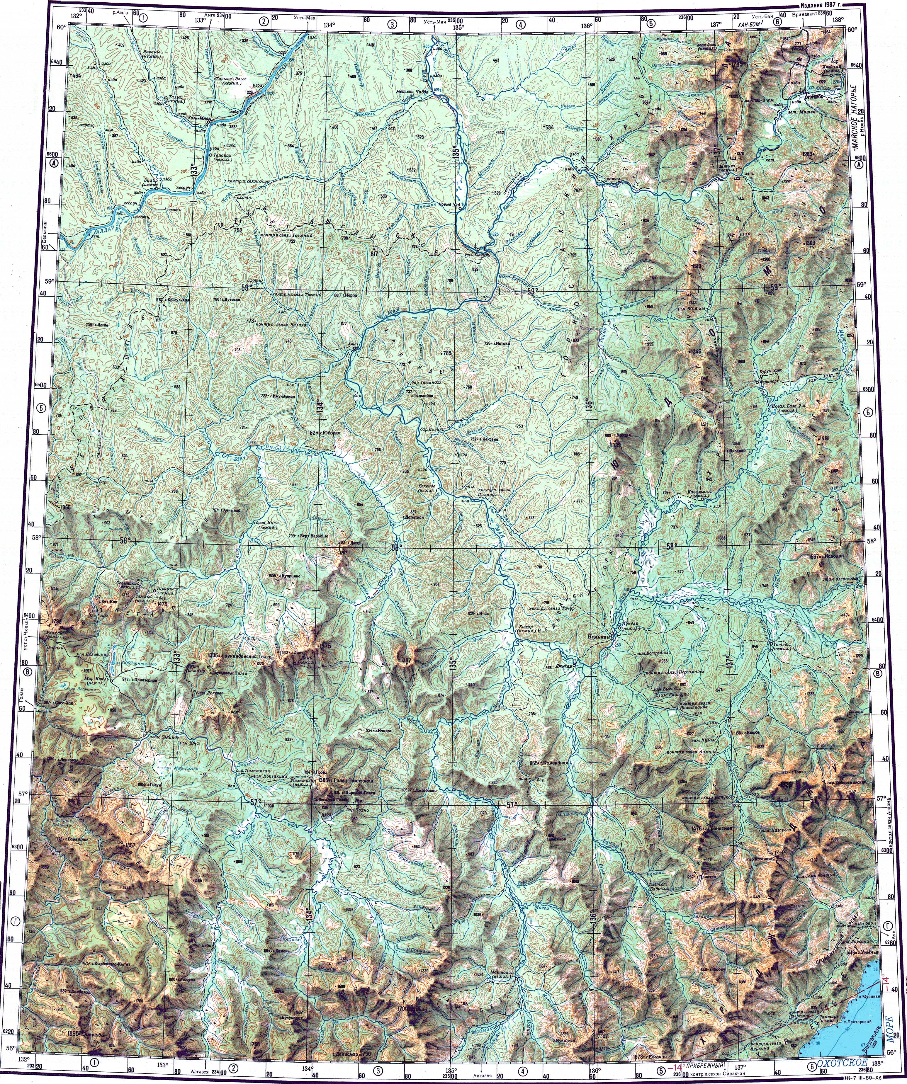
A unique orographic feature of the region is the circular, crater-like Kondyor Massif.[13] Minerals mining in the district includes one of the largest Zirconium reserves in Russia, at the Algama mine.
In the sharply continental zone, which gets very little precipitation and is humidity free, average winter and summer temperatures vary from −40 to −45 °C (−40 to −49 °F) and from +26 to +30 °C (79 to 86 °F) respectively.
Demographics[edit]
Ethnic composition (2021):[14]
- Evenks – 51.9%
- Russians – 38.8%
- Nivkh – 1.4%
- Altai – 1.3%
- Ukrainians – 1.2%
- Others – 5.4%
History[edit]

In the 17th century, shortly after the establishment of Yakutsk, the exploration of what is now Ayano-Maysky District pursued two goals. Yakutsk officials through eastward expansion sought to come up with new sources of tribute for the Tsar's treasury while at the same time trying to find a shorter, more convenient passage to the Sea of Okhotsk, in order to continue to care for the needs of rich Russian colonies in the Far East and North America.
In 1639, a group of Russian explorers under the leadership of Ivan Moskvitin reached the Sea of Okhotsk for the first time through the territory of modern Ayano-Maysky District.
In the first half of the 19th century, the Russian-American Company became the first trading company in the region, with its merchant office located in the port of Okhotsk. In 1842, the Company decided to find a better, more advantageous spot for a seaport. Consequently, in 1845 the Russian-American Company's merchant office was moved to Ayan.
Ayan's prosperity, however, was not to last. After the Alaska Purchase, life was virtually brought to a standstill. By 1867, the Russian-American Company was no longer in business. Many local businessmen and professionals joined the exodus of merchants who had discontinued their operations in the area. A recently (1850s) built and much more conveniently located Nikolayevsk-on-Amur became Russia's new main port in the Sea of Okhotsk region.
In the Russian Civil War, the territory of modern Ayano-Maysky District was the scene of the anti-Soviet Yakut Revolt. It was the last enclave of the White Forces, where General Anatoly Pepelyayev did not capitulate until June 17, 1923.
By decree of the Soviet government, Ayano-Maysky District was officially formed on December 10, 1930 by combining the areas of Ayan and Nelkan. Ayan was assigned the role of being the administrative center. In the 1930s, the Soviet government began forming state and collective farms, opened local schools and hospitals, amateur musical clubs, and otherwise encouraged the Evenks to switch from their nomadic lifestyle to a settled way of life.
In 1936, the first local farmers' market was opened with hopes of bringing locals together. State farm workers and private small farm owners sold their meat, wild game, fish, berries, mushrooms, etc.
People who made the decision to make this region their temporary home received added governmental bonuses to their pay and an earlier retirement age: for men when they reached 55 and women at 50.
With the dissolution of the Soviet Union, however, some state farms and enterprises were disbanded and government subsidies discontinued, forcing many residents to move out of the settlements to bigger cities or other regions of Russia.
References[edit]
Notes[edit]
- ^ a b c Resolution #143-pr
- ^ a b Государственный комитет Российской Федерации по статистике. Комитет Российской Федерации по стандартизации, метрологии и сертификации. №ОК 019-95 1 января 1997 г. «Общероссийский классификатор объектов административно-территориального деления. Код 08 206», в ред. изменения №278/2015 от 1 января 2016 г.. (State Statistics Committee of the Russian Federation. Committee of the Russian Federation on Standardization, Metrology, and Certification. #OK 019-95 January 1, 1997 Russian Classification of Objects of Administrative Division (OKATO). Code 08 206, as amended by the Amendment #278/2015 of January 1, 2016. ).
- ^ a b "Descriptive Statistics - Ayano-Maysky District" (in Russian). Federal State Statistics Service, Russian Federation. Archived from the original on June 5, 2016. Retrieved July 2, 2016.
- ^ a b c Russian Federal State Statistics Service (2011). Всероссийская перепись населения 2010 года. Том 1 [2010 All-Russian Population Census, vol. 1]. Всероссийская перепись населения 2010 года [2010 All-Russia Population Census] (in Russian). Federal State Statistics Service.
- ^ "26. Численность постоянного населения Российской Федерации по муниципальным образованиям на 1 января 2018 года". Federal State Statistics Service. Retrieved January 23, 2019.
- ^ a b Law #194
- ^ Law #191
- ^ Law #208
- ^ "Об исчислении времени". Официальный интернет-портал правовой информации (in Russian). June 3, 2011. Retrieved January 19, 2019.
- ^ Federal State Statistics Service (May 21, 2004). Численность населения России, субъектов Российской Федерации в составе федеральных округов, районов, городских поселений, сельских населённых пунктов – районных центров и сельских населённых пунктов с населением 3 тысячи и более человек [Population of Russia, Its Federal Districts, Federal Subjects, Districts, Urban Localities, Rural Localities—Administrative Centers, and Rural Localities with Population of Over 3,000] (XLS). Всероссийская перепись населения 2002 года [All-Russia Population Census of 2002] (in Russian).
- ^ Всесоюзная перепись населения 1989 г. Численность наличного населения союзных и автономных республик, автономных областей и округов, краёв, областей, районов, городских поселений и сёл-райцентров [All Union Population Census of 1989: Present Population of Union and Autonomous Republics, Autonomous Oblasts and Okrugs, Krais, Oblasts, Districts, Urban Settlements, and Villages Serving as District Administrative Centers]. Всесоюзная перепись населения 1989 года [All-Union Population Census of 1989] (in Russian). Институт демографии Национального исследовательского университета: Высшая школа экономики [Institute of Demography at the National Research University: Higher School of Economics]. 1989 – via Demoscope Weekly.
- ^ "O-53 Topographic Chart (in Russian)". Retrieved May 5, 2023.
- ^ Kondyor Massif, Russian Far East - NASA photos
- ^ "Таблица 1. Национальный состав населения". Habstat. Retrieved August 14, 2023.
Sources[edit]
- Правительство Хабаровского края. Постановление №143-пр от 18 июля 2007 г. «Об утверждении реестра административно-территориальных и территориальных единиц Хабаровского края», в ред. Постановления №273-пр от 28 августа 2015 г. «О внесении изменений в Постановление Правительства Хабаровского края от 18 июля 2007 г. №143-пр "Об утверждении реестра административно-территориальных и территориальных единиц Хабаровского края"». Вступил в силу 13 августа 2007 г. Опубликован: "Собрание законодательства Хабаровского края", №7(60), 12 августа 2007 г. (Government of Khabarovsk Krai. Resolution #143-pr of July 18, 2007 On the Adoption of the Registry of the Administrative-Territorial and Territorial Units of Khabarovsk Krai, as amended by the Resolution #273-pr of August 28, 2015 On Amending the Resolution #143-pr of the Government of Khabarovsk Krai of July 18, 2007 "On the Adoption of the Registry of the Administrative-Territorial and Territorial Units of Khabarovsk Krai". Effective as of August 13, 2007.).
- Законодательная Дума Хабаровского края. Закон №194 от 30 июня 2004 г. «О наделении муниципальных образований районов статусом муниципального района и об установлении их границ», в ред. Закона №40 от 27 октября 2010 г «О внесении изменения в Приложение 15 к Закону Хабаровского края "О наделении муниципальных образований районов статусом муниципального района и об установлении их границ"». Вступил в силу со дня официального опубликования. Опубликован: "Приамурские ведомости", №№139–140, 31 июля 2004 г. (Legislative Duma of Khabarovsk Krai. Law #194 of June 30, 2004 On Granting the District Municipal Formations the Status of the Municipal Districts and on Establishing Their Borders, as amended by the Law #40 of October 27, 2010 On Amending Appendix 15 of the Law of Khabarovsk Krai "On Granting the District Municipal Formations the Status of the Municipal Districts and on Establishing Their Borders". Effective as of the day of the official publication.).
- Законодательная Дума Хабаровского края. Закон №191 от 30 июня 2004 г. «О наделении административных центров районов статусом городского, сельского поселения и об установлении их границ», в ред. Закона №172 от 29 февраля 2012 г. «Об упразднении сельского населённого пункта посёлок Фестивальный, находящегося на территории Солнечного района Хабаровского края, и о внесении изменений в отдельные Законы Хабаровского края». Вступил в силу со дня официального опубликования. Опубликован: "Приамурские ведомости", №№126–127, 15 июля 2004 г. (Legislative Duma of Khabarovsk Krai. Law #191 of June 30, 2004 On Granting the Administrative Centers of the Districts the Status of Urban, Rural Settlements and on Establishing Their Borders, as amended by the Law #172 of February 29, 2012 On the Abolition of the Rural Locality of the Settlement of Festivalny on the Territory of Solnechny District of Khabarovsk Krai and on Amending Various Laws of Khabarovsk Krai. Effective as of the day of the official publication.).
- Законодательная Дума Хабаровского края. Закон №208 от 28 июля 2004 г. «О наделении поселковых, сельских муниципальных образований статусом городского, сельского поселения и об установлении их границ», в ред. Закона №98 от 29 июля 2015 г. «О внесении изменений в Приложение 2 к Закону Хабаровского края "О наделении поселковых, сельских муниципальных образований статусом городского, сельского поселения и об установлении их границ"». Вступил в силу со дня официального опубликования. Опубликован: "Приамурские ведомости", №№156–159, 20–21 августа 2004 г. (Legislative Duma of Khabarovsk Krai. Law #208 of July 28, 2004 On Granting the Settlement and Rural Municipal Formations the Status of Urban, Rural Settlements and on Establishing Their Borders, as amended by the Law #98 of July 29, 2015 On Amending Appendix 2 to the Law of Khabarovsk Krai "On Granting the Settlement and Rural Municipal Formations the Status of Urban, Rural Settlements and on Establishing Their Borders". Effective as of the day of the official publication.).
External links[edit]
- Official website of Ayano-Maysky District (in Russian)
- Official website of Khabarovsk Krai. Information about Ayano-Maysky District (in Russian)
Places adjacent to Ayano-Maysky District | |
|---|---|
| Districts | ||
|---|---|---|
| Cities and towns | ||
| Urban-type settlements | ||