
Captain Cook Highway
Captain Cook Highway | |
|---|---|
 | |
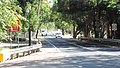
| The highway at Craiglie near Port Douglas | |
 | |
Captain Cook Highway (green on black) | |
| General information | |
| Type | Highway |
| Length | 75 km (47 mi) |
| Route number(s) |
|
| Major junctions | |
| South end | |
| |
| North end | Mossman-Daintree Road, Mossman |
| Location(s) | |
| Major settlements | Smithfield, Palm Cove, Port Douglas |
| Highway system | |
The Captain Cook Highway is a short, regional highway in Queensland which originates in Cairns and terminates in Mossman, where it joins Mossman-Daintree Road, continuing to Daintree. It is a state-controlled regional road (number 20A).[2][3][4]
The Captain Cook Highway is used to connect the CBD of Cairns to the Northern Beaches; a collection of suburbs which comprise the northern section of Cairns. It is also used by many tourists travelling to the town of Port Douglas, north of Cairns. Apart from being a vital link between two tourist locations, the Captain Cook Highway is a scenic highway that winds alongside the coast of the tropical seaside rainforest heading towards Port Douglas and Daintree National Park.
Route description[edit]
The Captain Cook Highway commences at the northern end of the Bruce Highway (Mulgrave Road), in the Cairns CBD. It runs through the CBD and the suburbs of Cairns North and Aeroglen as Sheridan Street, with a speed limit of 60km/h. In this section, it intersects with Airport Drive, providing a connection to Cairns Airport. After the intersection with Aeroglen Drive, the northerly and southerly directions of the highway become separated by a median and the speed limit increases to 80km/h. It runs as National Route 1 north past the suburbs of Machans Beach, Holloways Beach, and Yorkeys Knob, until it reaches the intersection of the Cairns Western Arterial Road towards the Redlynch Valley.
As of 25 November 2021, the highway branches off from this intersection onto the Smithfield Bypass (now renamed Kudakai Crossland Connection); a two-lane highway which follows a path to the east of the Smithfield business centre. This was constructed at a cost of $164 million.[1]
The original route continues north to the intersection of the Kennedy Highway in Smithfield, next to the Smithfield Shopping Centre. From this intersection, the highway continues north to the intersection of McGregor road, next to James Cook University, where it joins with the Smithfield Bypass. The two routes recombine and continue north as State Route 44 past the suburbs of Trinity Park, Trinity Beach, Kewarra Beach, Clifton Beach, Palm Cove, and Ellis Beach. It then continues along the coast through Wangetti, Craiglie and Killaloe, then west between Bonnie Doon in the north and Cassowary and Shannonvale in the south, where it passes the exit to Mossman-Mount Molloy Road (State Route 44) to the south, before turning north-west to its terminus in Mossman.
History[edit]
The highway was closed in December 2023 after heavy rain caused landslips, debris and significant damage.[5] Reopening occurred on the 20 January 2024.
Upgrades[edit]
Upgrade planning[edit]
A project to analyse options for upgrading a section of road from Poolwood Road roundabout to Endeavour Road, at a cost of $620,000, was to be completed by mid-2021.[6]
Upgrade construction[edit]
A project to upgrade the road between Cairns and Smithfield, at a cost of $359 million, was expected to commence construction in June 2022.[7]
Mossman–Mount Molloy Road[edit]
Mossman–Mount Molloy Road
| |
|---|---|
| Location | Captain Cook Highway, Bonnie Doon, Cassowary, Shannonvale tripoint to Mulligan Highway, Mount Molloy |
| Length | 28.4 km (17.6 mi) |
| Route number | 44 |
Mossman–Mount Molloy Road is a state-controlled district road (number 653).[3][4] It starts at an intersection with Captain Cook Highway (State Route 44) at the Bonnie Doon, Cassowary, Shannonvale tripoint. It runs south as State Route 44, for 28.4 kilometres (17.6 mi) to Mount Molloy, where it ends at an intersection with Mulligan Highway. The road has no major intersections .[8]
Major intersections[edit]
| LGA | Location | km | mi | Destinations | Notes |
|---|---|---|---|---|---|
| Cairns | Cairns | 0 | 0.0 | Sheridan Street – south–east – Cairns CBD / Florence Street – north–east – Cairns waterfront | Southern end of Captain Cook Highway (National Route 1) Continues north–west as Sheridan Street. |
| Barron River | 6.9 | 4.3 | William Walter Mason Bridges | ||
| Cairns | Smithfield | 12.1 | 7.5 | Smithfield Bypass – north – Smithfield/Trinity Park | Smithfield Bypass is now renamed Kudakai Crossland Connection. Captain Cook Highway now follows the bypass.[1] |
| 13.1 | 8.1 | Captain Cook Highway continues north as State Route 44 | |||
| Douglas | Port Douglas | 61.1 | 38.0 | Port Douglas Road – north–east – Port Douglas | |
| Bonnie Doon / Shannonvale / Cassowary tripoint[9] | 71.2 | 44.2 | Captain Cook Highway continues west with no route number | ||
| Mossman | 75.4 | 46.9 | Mill Street – east – Mossman CBD / Mossman Daintree Road (Foxton Avenue) – north–west – Daintree / Junction Road – north–east – Bonnie Doon | Northern end of Captain Cook Highway | |
1.000 mi = 1.609 km; 1.000 km = 0.621 mi
| |||||
Gallery[edit]
-
 Captain Cook Highway, Ellis Beach, 2018
 -
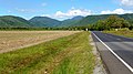
 Captain Cook Highway, Wangetti, 2015
 -
 Captain Cook Highway, Craiglie, 2015
 -
 Captain Cook Highway at Mossman, 2015

.JPG)

See also[edit]
References[edit]
- ^ a b c "Captain Cook Highway, Smithfield Bypass". Queensland Government. 13 December 2021. Archived from the original on 1 June 2022. Retrieved 1 June 2022.
- ^ Hema, Maps (2007). Australia Road and 4WD Atlas (Map). Eight Mile Plains Queensland: Hema Maps. p. 14. ISBN 978-1-86500-456-3.
- ^ a b "North Queensland Region map" (PDF). Department of Transport and Main Roads ©State of Queensland [CC BY 4.0]. 2020. Archived (PDF) from the original on 22 October 2023. Retrieved 7 July 2023.
- ^ a b "Far North District map" (PDF). Department of Transport and Main Roads ©State of Queensland [CC BY 4.0]. 2020. Archived (PDF) from the original on 7 July 2023. Retrieved 7 July 2023.
- ^ Herrmann, Bridget; Testa, Christopher; Richardson, Holly; McKillop, Charlie (10 January 2024). "Re-opening dates set for Captain Cook, Palmerston highways in flood-ravaged Far North Queensland". ABC News. Retrieved 22 January 2024.
- ^ "Captain Cook Highway (Cairns-Mossman) Poolwood Road roundabout to Endeavour Road, planning". Queensland Government. 22 November 2021. Archived from the original on 1 June 2022. Retrieved 1 June 2022.
- ^ "Cairns Ring Road (Cairns CBD to Smithfield)". Queensland Government. 18 February 2022. Archived from the original on 5 July 2022. Retrieved 5 July 2022.
- ^ Google (16 July 2023). "Mossman to Mount Molloy" (Map). Google Maps. Google. Retrieved 16 July 2023.
- ^ Google (20 July 2017). "Bonnie Doon / Shannonvale / Cassowary tripoint" (Map). Google Maps. Google. Retrieved 20 July 2017.
External links[edit]
![]() Media related to Captain Cook Highway at Wikimedia Commons
Media related to Captain Cook Highway at Wikimedia Commons