
Elterwater
| Elterwater | |
|---|---|
| Village | |
 | |
 Elterwater Location in the former South Lakeland district  Elterwater Location within Cumbria | |
| OS grid reference | NY327048 |
| Civil parish | |
| Unitary authority | |
| Ceremonial county | |
| Region | |
| Country | England |
| Sovereign state | United Kingdom |
| Post town | AMBLESIDE |
| Postcode district | LA22 |
| Dialling code | 015394 |
| Police | Cumbria |
| Fire | Cumbria |
| Ambulance | North West |
| UK Parliament | |
Elterwater is a village in the English Lake District and the county of Cumbria. The village lies half a mile (800 m) north-west of the lake of Elter Water, from which it derives its name. Both are situated in the valley of Great Langdale.[1]
Elterwater Bridge is a Grade II listed structure dating to at least the 18th century.[2]
Economic activity
[edit]In the past, the principal industries have been farming, quarrying for slate and gunpowder manufacture. The first two activities continue, while evidence of the latter survives in the grounds of the Langdale Estate,[3] a holiday development founded in the 1930s and redeveloped as a timeshare in the 1980s.
In the present day, tourism is a principal source of income and the village is popular with visitors of all kinds, particularly fell-walkers due to its proximity to many of the Lake Districts most popular fells. The village is home to a plethora of holiday homes, as well as the Britannia Inn and Elterwater Hostel, a former YHA hostel, that was saved from closure and taken independent in 2013.[4]
Art
[edit]In the 1880s, the Guild of St George founded by John Ruskin revived small-scale linen spinning and weaving in Langdale, at a cottage in Elterwater, led by Albert Fleming and Marion Twelves and continued by Elizabeth Pepper.[5] The decorative textiles became known as Ruskin Lace. In 1947, German artist Kurt Schwitters created one of his Merzbau in a barn at Cylinders. This three-dimensional artwork, and the entire wall on which it was installed, was moved to the Hatton Gallery in Newcastle in 1965. Artist Bernard Eyre-Walker lived and painted in Elterwater in the 1930s and 40s. Watercolour painter Thomas Frederick Worrall's painting Elterwater Tarn and Langdale Pikes is in the Bishop of Carlisle's house in Keswick.
Only a quarter of the houses in Elterwater are permanently occupied, the rest being holiday cottages.[6]
Etymology
[edit]" 'The lake frequented by swans', from ON 'elptr'/'alpt' 'swan', in the gen.[itive], sing.[ular] form with '-ar', and 'water', probably replacing ON 'vatn' 'lake'. Whooper swans still winter on the lake".[7] (ON is Old Norse).
Gallery
[edit]-
 A road sign in Elterwater
 -
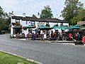 The Britannia Inn, 2019


References
[edit]- ^ Parker, John (2002). An Atlas of the English Lakes: Pictorial Charts Compiled from an Exploration of the Shorelines of the Lake District on Foot and by Canoe. Cicerone. p. 37. ISBN 1852843551.
- ^ Elterwater Bridge, Lakes – Historic England
- ^ Jecock, Marcus, "Elterwater Gunpowder Works, Cumbria: an archaeological and historical survey". English Heritage Report Series AI/9/2003, 2003.
- ^ "Closure and sale of two youth hostels is a 'crying shame' after decades of welcoming old and young alike". Westmorland Gazette. 25 April 2013.
- ^ Brunton, Jennie, "The Arts and Crafts Movement in the Lake District". Centre for North West Regional Studies, 2001, pp 57-86.
- ^ "Elterwater - Visit Cumbria". www.visitcumbria.com.
- ^ Whaley, Diana (2006). A dictionary of Lake District place-names. Nottingham: English Place-Name Society. pp. lx, 423 p.108–109. ISBN 0904889726.
Bibliography
[edit]- Parker, John Wilson (2004). An Atlas of the English Lakes. Cicerone Press. ISBN 1-85284-355-1.
External links
[edit]![]() Media related to Elterwater at Wikimedia Commons
Media related to Elterwater at Wikimedia Commons
This Cumbria location article is a stub. You can help Wikipedia by expanding it. |