Evergreen, Colorado
Evergreen, Colorado | |
|---|---|
Unincorporated Town | |
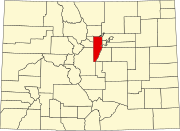
 Location in Jefferson County and the state of Colorado | |
| Country | |
| State | |
| County | Jefferson[1] |
| Settled | 1859 |
| Area | |
| • Total | 11.6 sq mi (30.1 km2) |
| • Land | 11.6 sq mi (30.0 km2) |
| • Water | 0.1 sq mi (0.2 km2) 0.52% |
| Elevation | 7,220 ft (2,200.6 m) |
| Population (2010) | |
| • Total | 9,038 |
| • Density | 795.7/sq mi (307.2/km2) |
| Time zone | UTC-7 (MST) |
| • Summer (DST) | UTC-6 (MDT) |
| ZIP codes[2] | 80439, 80437 |
| Area code | 303 |
| FIPS code | 08-25390 |
| GNIS feature ID | 0204712 |
| Website | Evergreen Area Chamber of Commerce |
Evergreen is a census-designated place (CDP) and a U.S. Post Office in Jefferson County, Colorado, United States. Evergreen is roughly 15 miles (24 km) west of Denver. The population was 9,038 at the 2010 census.[3][4]
History
This section needs additional citations for verification. (February 2011) |
Homesteader Thomas Bergen arrived in 1859, establishing a ranch and stage stop north of present-day downtown Evergreen. Bergen's Ranch was recognized as a settled area at the establishment of Jefferson County, Jefferson Territory. Subsequent settlers homesteaded south of Bergen along Bear Creek Canyon and the downtown area grew around the confluence of Cub Creek and Bear Creek. Fellow homesteader Dwight P. Wilmot is credited with naming the area "Evergreen"; his home has been preserved and still functions as a private residence across the street from his namesake Wilmot Elementary School.
The town grew on the lumber demand for buildings in Denver and by the 1880s, the town could boast a population of 200 people and six operating sawmills. Improvement of the road from Denver up Bear Creek Canyon in 1911 and electrical service reaching the town in 1917 spurred further growth and the town became a popular summer destination for Denver residents. Resorts like Troutdale-in-the-Pines, Greystone Guest Ranch and the Brook Forest Inn opened and entertained Denverites and celebrities including film stars of the day and Presidents Franklin D. Roosevelt and Theodore Roosevelt, both whom vacationed at Troutdale. During the 1950s, improved utilities in town and the rising popularity of automobiles began to entice more future residents to stay year-round and the town became known as a commuter community.
Law and government
Since Evergreen is an unincorporated area, services usually provided by a city's government are provided by multiple agencies. The county maintains the roads (less State Highway 74), oversees planning and zoning, provides primary and secondary education through its school district and provides law enforcement through its sheriff's office. Evergreen Fire/Rescue provides fire protection and emergency medical response service. Water and sewer services operate under the administration of the Evergreen Metropolitan District.
Geography
Evergreen sits at an elevation of 7,220 feet (2,200 m) in the Rocky Mountains, 15 miles west of Denver, Colorado. Evergreen is located at 39°38′20″N 105°20′11″W / 39.63889°N 105.33639°W (39.638905, -105.336318).[5]
According to the United States Census Bureau, the CDP has a total area of 11.6 square miles (30 km2), of which, 11.6 square miles (30 km2) of it is land and 0.1 square miles (0.26 km2) of it (0.52%) is water.
Climate
| Climate data for Evergreen, Colorado (Elevation 7,220ft) | |||||||||||||
|---|---|---|---|---|---|---|---|---|---|---|---|---|---|
| Month | Jan | Feb | Mar | Apr | May | Jun | Jul | Aug | Sep | Oct | Nov | Dec | Year |
| Record high °F (°C) | 74 (23) |
71 (22) |
78 (26) |
82 (28) |
92 (33) |
97 (36) |
96 (36) |
96 (36) |
92 (33) |
85 (29) |
77 (25) |
69 (21) |
97 (36) |
| Mean daily maximum °F (°C) | 44.3 (6.8) |
45.3 (7.4) |
50.1 (10.1) |
56.7 (13.7) |
65.0 (18.3) |
75.5 (24.2) |
81.6 (27.6) |
79.5 (26.4) |
72.2 (22.3) |
62.2 (16.8) |
51.0 (10.6) |
44.8 (7.1) |
60.7 (15.9) |
| Mean daily minimum °F (°C) | 10.2 (−12.1) |
12.1 (−11.1) |
18.5 (−7.5) |
25.7 (−3.5) |
33.9 (1.1) |
41.3 (5.2) |
47.0 (8.3) |
45.5 (7.5) |
37.2 (2.9) |
27.0 (−2.8) |
18.2 (−7.7) |
10.9 (−11.7) |
27.3 (−2.6) |
| Record low °F (°C) | −38 (−39) |
−28 (−33) |
−18 (−28) |
−9 (−23) |
12 (−11) |
27 (−3) |
26 (−3) |
29 (−2) |
8 (−13) |
−8 (−22) |
−15 (−26) |
−29 (−34) |
−38 (−39) |
| Average precipitation inches (mm) | 0.55 (14) |
0.72 (18) |
1.62 (41) |
2.18 (55) |
2.55 (65) |
2.09 (53) |
2.27 (58) |
2.26 (57) |
1.45 (37) |
1.26 (32) |
0.91 (23) |
0.77 (20) |
18.64 (473) |
| Average snowfall inches (cm) | 8.5 (22) |
10.3 (26) |
18.2 (46) |
13.7 (35) |
3.3 (8.4) |
0.1 (0.25) |
0.0 (0.0) |
0 (0) |
1.4 (3.6) |
7.2 (18) |
11.6 (29) |
10.4 (26) |
84.7 (215) |
| Source: The Western Regional Climate Center[6] | |||||||||||||
Major Parks

Evergreen is surrounded by thousands of acres of land in the Denver Mountain Parks and Jefferson County Open Space park systems. The Denver Mountain Parks in the area are Bergen Park, Corwina Park, Dedisse Park, Dillon Park, Fillius Park, O'Fallon Park and Pence Park in Indian Hills. The Jefferson County Open Space Parks are Alderfer/Three Sisters, Elk Meadow, Lair o' the Bear, and Mount Falcon Park in Indian Hills. Hiwan Golf Club, a country club located just east of Bergen Park, is Evergreen's only country club. Popular both in the summer and the winter, Evergreen Lake and its "Lake House" are recreational focal points for the area.
Transportation
The two major roads in Evergreen are State Highway 74 and County Highway 73. Highway 74 runs south from Interstate 70 through Bergen Park and northern Evergreen to downtown, then turns east and follows Bear Creek Canyon to its end at State Highway 8 near Red Rocks Park. Highway 73 runs south from downtown Evergreen to connect with U.S. Highway 285 in Conifer.
Bus service in Evergreen is offered by Denver Regional Transportation District. TheRide regional routes E and Z run to downtown Denver and there is call-n-Ride curb-to-curb transportation service in town.[7]
Demographics
As of the census[4] of 2000, there were 9,216 people, 3,591 households, and 2,689 families residing in the CDP. The population density was 795.7 people per square mile (307.3/km2). There were 3,840 housing units at an average density of 331.5 per square mile (128.0/km2). The racial makeup of the CDP was 97.35% White, 0.26% African American, 0.36% Native American, 0.62% Asian, 0.07% Pacific Islander, 0.25% from other races, and 1.10% from two or more races. Hispanic or Latino of any race were 2.08% of the population.

There were 3,591 households out of which 36.1% had children under the age of 18 living with them, 65.6% were married couples living together, 6.5% had a female householder with no husband present, and 25.1% were non-families. 19.2% of all households were made up of individuals and 3.5% had someone living alone who was 65 years of age or older. The average household size was 2.56 and the average family size was 2.94.
In the CDP the population was spread out with 25.9% under the age of 18, 4.6% from 18 to 24, 29.6% from 25 to 44, 31.7% from 45 to 64, and 8.2% who were 65 years of age or older. The median age was 41 years. For every 100 females there were 99.4 males. For every 100 females age 18 and over, there were 96.6 males.
The median income for a household in the CDP was $79,380, and the median income for a family was $88,589. Males had a median income of $62,917 versus $37,392 for females. The per capita income for the CDP was $36,654. About 2.3% of families and 3.0% of the population were below the poverty line, including 1.3% of those under age 18 and 4.7% of those age 65 or over.
Sites of interest

Evergreen Lake, a popular recreation area, was created by damming Bear Creek in 1927. It sits above downtown Evergreen, which includes a mix of historic buildings and local businesses, including the well-known entertainment venue and restaurant The Little Bear.
In the winter, ice skating is offered at Evergreen Lake. The skating season usually runs from mid-to-late December (approximately Christmas) to late March depending upon ice thickness and weather.
Registered Historic Places in Evergreen include:
- Bergen Park
- Dedisse Park
- Evergreen Conference District
- Everhardt Ranch
- Fillius Park
- Hiwan Homestead
- Humphrey House
- O'Fallon Park
- Pence Park
Education
Areas of Evergreen lying within Jefferson County are served by Jefferson County Schools. Most students live within the Evergreen High School catchment area, while parts of southern Evergreen fall into the area for Conifer High School. Residents west of the Clear Creek County line are served by Clear Creek Schools with students attending King-Murphy Elementary (ranked in the top 1% of elementary schools in Colorado), Clear Creek Middle School, and Clear Creek High School.
Private schools in Evergreen include Evergreen Academy, Evergreen Country Day School, Grace Christian School, and Montessori School Of Evergreen.
Notable residents
- South Park co-creator Trey Parker graduated from Evergreen High School in 1988. Much of the early show is based on Parker's experiences living in nearby Conifer.
- Space Shuttle astronaut Jeffrey Ashby graduated from Evergreen High School in 1972.
- Country star Willie Nelson owned a 44-acre ranch in Evergreen for several years, but sold it in 1991.[8]
- MLB player Kevin Kouzmanoff grew up in Evergreen and graduated from Evergreen High School in 1999.
- Diane Mott Davidson, Anthony award-winning and New York Times best-selling author
- Joanne Greenberg, author of I Never Promised You a Rose Garden, currently resides in Evergreen.
- Jasmine Cresswell, Noted romance novelist summers in Evergreen.
- Levi Brackman, author, rabbi and noted Jewish writer and thinker leads a Jewish community in Evergreen.
- John Hinckley, Jr., shot President Ronald Reagan, lived in Evergreen.[9]
- Berkley Breathed, noted author.
- Gary Hart, former U.S. senator.
- Scott Hamilton, Olympic medalist.
See also
- Outline of Colorado
- State of Colorado
References
- ^ "US Board on Geographic Names". United States Geological Survey. 2007-10-25. Retrieved 2008-01-31.
- ^ "ZIP Code Lookup" (JavaScript/HTML). United States Postal Service. December 14, 2006. Retrieved December 14, 2006.
- ^ Colorado Trend Report 2: State and Complete Places (Sub-state 2010 Census Data). Missouri Census Data Center. Accessed 2011-02-25.
- ^ a b "American FactFinder". United States Census Bureau. Retrieved 2008-01-31.
- ^ "US Gazetteer files: 2010, 2000, and 1990". United States Census Bureau. 2011-02-12. Retrieved 2011-04-23.
- ^ "Seasonal Temperature and Precipitation Information". Western Regional Climate Center. Retrieved November 18, 2013.
- ^ RTD Evergreen call-n-Ride.
- ^ https://news.google.com/newspapers?nid=1914&dat=19910807&id=az0pAAAAIBAJ&sjid=yGUFAAAAIBAJ&pg=3478,1297158
- ^ The Trial of John W. Hinckley, Jr., by Doug Linder. 2008.

