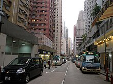
Fort Street, Hong Kong


Fort Street is a street in North Point in Hong Kong. The street, primarily residential, runs from west to east, parallel to King's Road, at a higher elevation.[how?][quantify] It is the location of the terminus of Hong Kong Island Green Minibus Route 65.
The eastern half of the street is a private road. Drivers pay to the cashier's office at the corner of North View Street for parking their vehicles.
Name[edit]
- The street was named after the nearby North Point Battery, established in 1879 and demolished in 1922.[1]
See also[edit]
References[edit]
- ^ Andrew Yanne; Gillis Heller (1 May 2009). Signs of a Colonial Era. Hong Kong University Press. pp. 134–. ISBN 978-962-209-944-9. Retrieved 28 June 2021.
Wikimedia Commons has media related to Fort Street, Hong Kong.
22°17′23″N 114°11′51″E / 22.28981°N 114.19738°E
