
Hope Bay Aerodrome
Hope Bay Aerodrome | |||||||||||
|---|---|---|---|---|---|---|---|---|---|---|---|
 On approach to the runway | |||||||||||
| Summary | |||||||||||
| Airport type | Private | ||||||||||
| Operator | Agnico Eagle Mines Limited | ||||||||||
| Time zone | MST (UTC−07:00) | ||||||||||
| • Summer (DST) | MDT (UTC−06:00) | ||||||||||
| Elevation AMSL | 155 ft / 47 m | ||||||||||
| Coordinates | 68°09′40″N 106°36′56″W / 68.16111°N 106.61556°W | ||||||||||
| Map | |||||||||||
 CHB3  CHB3 | |||||||||||
| Runways | |||||||||||
| |||||||||||
Source: Canada Flight Supplement[1] | |||||||||||
Hope Bay Aerodrome (IATA: UZM, TC LID: CHB3) is an aerodrome located near Hope Bay, Nunavut, Canada. The runway serves the gold exploration camps in the area.
Airlines and destinations
| Airlines | Destinations |
|---|---|
| Canadian North | Charter: Cambridge Bay, Yellowknife |
Hope Bay Mine
-
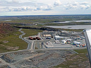
 View of Hope Bay from the south
 -
 Main Camp
 -
 Mine shaft has now been sealed
 -
 Broad view of Hope Bay
 -
 First camp site


See also
References
External links
Wikimedia Commons has media related to Hope Bay Gold Mine.
- Past three hours METARs, SPECI and current TAFs for Hope Bay Aerodrome from Nav Canada as available.
| By name | |
|---|---|
| By location indicator | |
| By province/territory | |
| By area | |
| National Airports System | |
| Related | |
This article about an airport in Nunavut is a stub. You can help Wikipedia by expanding it. |