
Molalla River State Park
| Molalla River State Park | |
|---|---|
 Grassy meadow along the walking trail | |
  | |
| Type | Public, state |
| Location | Clackamas County, Oregon |
| Nearest city | Canby |
| Coordinates | 45°17′44″N 122°42′09″W / 45.2956758°N 122.7025931°W[1] |
| Area | 567 acres (229 ha)[2] |
| Operated by | Oregon Parks and Recreation Department |
| Status | Day use only, year-round |
The Molalla River State Park is located in U.S. state of Oregon. It is a few miles north of Canby, and half a mile from the Canby Ferry. The park is south of the Willamette River and east of the Molalla River, at the confluence of the Pudding, Molalla and Willamette rivers. The Pudding River flows into the Molalla from the west, just before the Molalla joins the Willamette. The floodplains of these rivers provide important habitat for waterfowl, wading birds, deer, small mammals, reptiles and amphibians. A blue heron rookery, one of the largest in the Willamette Valley, is located in Molalla River State Park.
Gallery[edit]
-
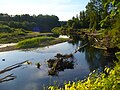 View of Molalla River from the walking trail
 -
 Playing in the autumn leaves
 -
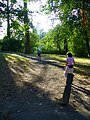 Beginning of the walking trail, at parking lot
 -
 Horseshoe pits


See also[edit]
References[edit]
- ^ "Molalla River State Park". Geographic Names Information System. United States Geological Survey, United States Department of the Interior. Retrieved July 1, 2011.
- ^ Bannan, Jan (2002). Oregon State Parks: A Complete Recreation Guide (2nd ed.). Seattle: The Mountaineers Books. pp. 126–27. ISBN 0-89886-794-0.
External links[edit]
- "Molalla River State Park". Oregon Parks and Recreation Department. Retrieved July 1, 2011.
- Pudding River Watershed Council
This Clackamas County, Oregon state location article is a stub. You can help Wikipedia by expanding it. |