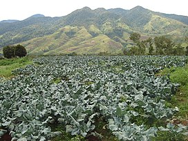
Mount Kalatungan
| Mount Kalatungan | |
|---|---|
| Mount Calatungan | |
 | |
| Highest point | |
| Elevation | 2,860 m (9,380 ft)[1][2] |
| Prominence | 1,502 m (4,928 ft)[3][4] |
| Listing | |
| Coordinates | 7°57′18″N 124°48′09″E / 7.95500°N 124.80250°E[1] |
| Geography | |
| Country | Philippines |
| Region | Northern Mindanao |
| Province | Bukidnon |
| Cities and municipalities | |
| Parent range | Kalatungan Mountain Range |
| Geology | |
| Age of rock | Holocene[1] |
| Mountain type | Stratovolcano[1] |
| Last eruption | Unknown[1] |
 | |
Mount Kalatungan, also known as Catatungan,[1] is a volcanic mountain located in the province of Bukidnon in the southern Philippines. It is a stratovolcano with no known historical eruptions and classified by the Philippine Institute of Volcanology and Seismology (PHIVOLCS) as a potentially active volcano.
It is the fifth highest mountain in the country with an elevation of 2,860 m (9,380 ft) asl. It is one of the several high elevation peaks in the Kalatungan Mountain Range in Bukidnon on the island of Mindanao, the second largest island in the Philippines.
The mountain is part of the ancestral domain of the Indigenous Talaandig people.[5]
See also[edit]
- Mount Kitanglad
- List of mountains in the Philippines
- List of Southeast Asian mountains
- List of active volcanoes in the Philippines
- List of potentially active volcanoes in the Philippines
- List of inactive volcanoes in the Philippines
References[edit]
- ^ a b c d e f "Kalatungan". Global Volcanism Program. Smithsonian Institution. Retrieved June 25, 2021.
- ^ Henares, Ivan (February 2, 2008). "The Highest Mountains in the Philippines". Pinoy Mountaineer. Retrieved October 29, 2008.
- ^ de Ferranti, Jonathan; Maizlish, Aaron (c. 2005). "Philippine Mountains: 29 Mountain Summits with Prominence of 1,500 Meters or Greater". Peaklist. Retrieved October 29, 2008.
- ^ "Kalatungan Mountains High Point, Philippines". Peakbagger.com. Retrieved November 5, 2008.
- ^ "Indigenous Tribes of Bukidnon". Jesuit Bukidnon Mission. Retrieved February 21, 2024.
External links[edit]
 Media related to Mount Kalatungan at Wikimedia Commons
- Mount Kalatungan - Mounta Wiji Traverse


