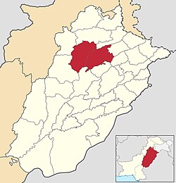
Sargodha Division
Appearance
Sargodha Division
سرگودھا ڈویژن | |
|---|---|
 Sargodha Division in Punjab | |
| Coordinates: 32°10′N 72°30′E / 32.167°N 72.500°E | |
| Country | |
| Province | |
| Capital | Sargodha |
| Established | 1960 |
| Districts | 2 |
| Government | |
| • Type | Divisional Administration |
| • Divisional Commissioner | Dr Irshad Ahmed |
| • Regional Police Officer | N/A |
| Area | |
| • Division | 26,360 km2 (10,180 sq mi) |
| Elevation | 155 m (509 ft) |
| Population (2023) | |
| • Division | 9,591,275 |
| • Density | 363.86/km2 (942.4/sq mi) |
| • Urban | 2,744,219 (28.61%) |
| • Rural | 6,847,056 |
| Literacy | |
| • Literacy rate |
|
| Time zone | UTC+5 (PST) |
| Postal code | 40100 (Sargodha) 41000 (Khushab) |
| Dialling code | 048 (Sargodha) 0454 (Khushab) |
| Website | sargodhadivision |
Sargodha Division is an administrative division of Punjab province, Pakistan. Sargodha city is the capital of the division. Divisions are the third tier of government below the federal and provincial levels.
In 2000, local government reforms abolished administrative divisions and raised the districts to become the new third tier of government.[2] But in 2008, the division system was restored again after the restoration of democratic government system.[3]
Districts
[edit]It consists of the following districts:
In 2023, Mianwali and Bhakkar District shifted to newly established Mianwali Division.
| # | District | Headquarter | Area
(km²)[4] |
Pop.
(2023) |
Density
(ppl/km²) (2023) |
Lit. rate
(2023) |
|---|---|---|---|---|---|---|
| 1 | Sargodha | Sargodha | 5,854 | 4,334,448 | 740.1 | 66.73% |
| 2 | Khushab | Jauharabad | 6,511 | 1,501,089 | 230.8 | 62.52% |
List of the Tehsils
[edit]| # | Tehsil | Area
(km²)[5] |
Pop.
(2023) |
Density
(ppl/km²) (2023) |
Lit. rate
(2023) |
Districts |
|---|---|---|---|---|---|---|
| 1 | Khushab | 2,115 | 816,682 | 386.14 | 65.94% | Khushab District |
| 2 | Noorpur Thal | 2,500 | 264,597 | 105.84 | 55.58% | |
| 3 | Quaidabad | 1,080 | 274,959 | 254.59 | 55.11% | |
| 4 | Naushera (Wadi-e-Soon) | 816 | 144,851 | 177.51 | 70.43% | |
| 5 | Bhalwal | 663 | 387,262 | 584.11 | 69.31% | Sargodha District |
| 6 | Bhera | 504 | 384,403 | 762.70 | 67.37% | |
| 7 | Kot Momin | 948 | 544,208 | 574.06 | 56.33% | |
| 8 | Sahiwal | 829 | 407,487 | 491.54 | 63.34% | |
| 9 | Sargodha | 1,536 | 1,800,455 | 1,172.17 | 71.82% | |
| 10 | Shahpur | 769 | 424,746 | 552.34 | 61.85% | |
| 11 | Sillanwali | 607 | 385,887 | 635.73 | 63.07% |
Demographics
[edit]According to 2023 census, Sargodha division had a population of 9,591,275.[6]
Notable people
[edit]- Malik Shakir Bashir Awan - President Tanzeem ul Awan, Politician, Lawyer, Social Activist
- Mohammad Hafeez – former captain of Pakistan national cricket team and Lahore Qalandars player
- Attaullah Khan Esakhelvi – Pakistani award-winning musician from Isakhel, Mianwali.
- Suhail Warraich – journalist and television host from Jauharabad, Khushab.
- Imran Khan – former Prime Minister of Pakistan from Mianwali.
- Misbah-ul-Haq – former Test captain and head coach of the Pakistan cricket team.
See also
[edit]References
[edit]- ^ "Literacy rate, enrolments, and out-of-school population by sex and rural/urban, CENSUS-2023" (PDF).
- ^ "Local government debate". Dawn. 2009-09-07. Retrieved 2022-11-17.
- ^ "History | Sargodha Division". sargodhadivision.punjab.gov.pk. Retrieved 2022-11-17.
- ^ "TABLE 1 : AREA, POPULATION BY SEX, SEX RATIO, POPULATION DENSITY, URBAN POPULATION, HOUSEHOLD SIZE AND ANNUAL GROWTH RATE, CENSUS-2023, PUNJAB" (PDF).
- ^ "TABLE 1 : AREA, POPULATION BY SEX, SEX RATIO, POPULATION DENSITY, URBAN POPULATION, HOUSEHOLD SIZE AND ANNUAL GROWTH RATE, CENSUS-2023, PUNJAB" (PDF).
- ^ https://www.pbs.gov.pk/sites/default/files/population/2023/tables/punjab/pcr/table_1.pdf [bare URL PDF]

