Shikarpur District
This article needs additional citations for verification. (December 2016) |
Shikarpur District
| |
|---|---|
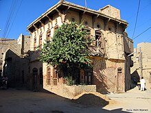
 Fields in Kingri | |
 | |
| Coordinates: 28°00′N 68°40′E / 28.000°N 68.667°E | |
| Country | |
| Province | |
| Division | Larkana |
| Established | 1977 |
| Founded by | Sindh Government |
| Headquarters | Shikarpur |
| Government | |
| • Type | District Administration |
| • Deputy Commissioner | N/A |
| • District Police Officer | N/A |
| • District Health Officer | N/A |
| Area | |
| • Total | 2,512 km2 (970 sq mi) |
| Population (2017)[1] | |
| • Total | 1,233,760 |
| • Density | 490/km2 (1,300/sq mi) |
| Time zone | UTC+5 (PST) |
| Website | Shikarpur Sindh www.shikarpur.tk |
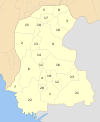
Shikarpur district (Template:Lang-sd, Template:Lang-ur), is a district in Sindh province in Pakistan. The city of Shikarpur is the district headquarters. There are 4 talukas: Lakhi Ghulam Shah, Garhi Yasin, Khanpur and Shikarpur itself. It is spread over an area of 2,512[2] km2.[3]
History

Shikarpur was an important place as commanding the trade route through the Bolan Pass, and its merchants have dealings with many towns in central Asia. Shikarpur was a city closed within a fort, that fort had seven gates: Hathi Gate, Lakhi Gate, Hazari gate, Khanpur Gate, Suvi Gate, Wagana Gate, Karan Gate & Noshero Gate.
The East India Company occupied Sindh in 1843; They formed three districts in Sindh administratively: Hyderabad, Karachi and Shikarpur.
In 1847 British Government created a new district named Upper Sind Frontier District.
Then the Shikarpur city was the District Headquarters till 1883 until the British Government Shifted District Headquarters to Sukkur. At that time Shikarpur had 14 talukas which covered the area of all North Sindh except Khairpur. Those days Shikarpur District had its boundaries from Kashmore to Dadu district nowadays.In 1901 British Government shifted district status from Shikarpur to Sukkur. Shikarpur was remain a taluka of Sukkur district. In 1977 Shikarpur again get the district status by the Sindh Government.
Geography
Shikarpur district borders Larkana, Jacobabad, Khairpur and Sukkur. Two National Highways (N-65 & N-55) intersect the city of Shikarpur making it the junction points of 4 provinces.
Places
The Shahi Bagh garden had a zoo with a number of lions, cheetahs, bears, and wild boars. These animals were later shifted to Karachi Zoo. The garden has a wooden pavilion that was designed by Perston Phel and constructed by Sir W. Merewether in September 1871. Many other public and private gardens and open spaces of Shikarpur have vanished.
The Covered Bazaar, contemporary cities of that time – Bukhara, Samarkand, and Istanbul – had bazaars with covered streets. Shikarpur's main bazaar too was covered. The long, narrow bazaar lined with shops on both sides almost pass through the centre of the old city.
Administrative divisions
The district of Shikarpur is sub-divided into four Tehsils these are:[4]
Demographics
At the time of the 2017 census, Shikarpur district had a population of 1,233,760, of which 635,558 were males and 598,130 females. The rural population was 929,319 (75.32%) and urban 304,441 (24.68%). The literacy rate is 40.48%: 51.65% for males and 28.79% for females.[1]
The majority religion is Islam, with 98.39% of the population. Hinduism (including those from Scheduled Castes) is practiced by 1.40% of the population.[1]
At the time of the 2017 census, 92.52% of the population spoke Sindhi, 3.39% Brahui, 1.30% Balochi and 1.22% Urdu as their first language.[1]
Traditional foods of Shikarpur
The traditional foods of Shikarpur are Achar(Pickle) and Kulfi Falooda. The pickle is sold by locals of Shikarpur city, The best pickle you'll find in Shikarpur is sold by locals living in Shah Hussain Mohala Shikarpur; Siddiqis are the locals who have the best pickle in Shikarpur city, the average quality pickle can be found on shops in Bazars(Markets), but for the best quality you must try Siddiqi's pickle. The Deevan Hotel sells the best Kulfi Falooda of Shikarpur, located at Lakhi Dar Shikarpur.
List of Dehs
The following is a list of Shikarpur District's dehs, organised by taluka:[5]
- Shikarpur Taluka (49 dehs)
- Abdal
- Ali Bahar
- Baid
- Barri
- Bekhari
- Bello Machi
- Bello Sultankot
- Chak Chandio Jagir
- Chak Jano
- Chodio Sadhyano Jagir
- Dakhan
- Daro Sono
- Dasti
- Dost Wah
- Ghaloo
- Hamayoon
- Jaggan
- Jahan Wah
- Jano
- Juneja
- Kakepota
- Karan
- Khan Wah
- Khuh Birro
- Lalyoon New
- Lalyoon Old
- Larr-wah
- Lodra
- Machi
- Mir Daho Jagir
- Muhammad Rahim
- Muhbat Fakir Jagir
- Mundho Wah
- Mureed Sethar
- Nimar Thariri
- Nizam Thariri
- Phulpota
- Pir Jalil
- Qazi Wah
- Rahuja
- Rais Wah
- Raj Wah
- Rip
- Shahal
- Shahwani/Chawni
- Shikarpur
- Sultan Kot
- Thahim Wah
- Wakrro Jagir
- Lakhi Taluka (52 dehs)
- Abad Malhi
- Abdoo
- Abdoo Jagir
- Adur Takio
- Aliabad
- Azeemabad
- Azmat Jagir
- Bagi
- Beechanji
- Bello Abad Malhani
- Bello Bageji
- Bello Bagerji Right Side Of Khirthar Canal
- Bhaya
- Bhirkan
- Borirri
- Chak
- Chand
- Dahar Jagir
- Fateh Tando
- Fath Pur
- Gahi Adu Shah
- Garhi Haleem
- Habib Kot
- Hothi
- Jamra
- Jehan Khan
- Jhali Kalwari
- Kalari
- Khahi
- Lakhi
- Maka
- Marri
- Miani
- Mungrani
- Nao Wah
- Nimhoro
- Noroo
- Qasim
- Qazi Wahan
- Ruk
- Rustam
- Sadeded Jagir
- Sahekji
- Sarfoo
- Shahqulipur
- Sherkot
- Soomrani
- Taib
- Theenda
- Usto Abdul Haque
- Wahi Majeed
- Wazirabad
- Khanpur Taluka (52 dehs)
- Ali Murad Kalhoro
- Areeja
- Arsallah
- Begari
- Bello Muhro Marri
- Bhatti
- Bijrani
- Bindi Shahpur
- Burirra
- Chiman Sukhpur
- Choi
- Chutto Loi
- Daranpur
- Darri
- Dhoung
- Garhih Budhal
- Garhi Dakho
- Garhi Taggo
- Jatoi
- Kachokot Shahu
- Katcho Loi
- Khanpur
- Khuhara
- Kumbranwati
- Lodki
- Mahmooda Bagh
- Mahmoodo
- Mian Sahib
- Mir Muhammad Pahore
- Mirza Wah
- Muhro Marri
- Nepiarabad
- Noon
- Noor Muhammad Shujrah
- Pacco Loi
- Pacokot Shahu
- Pahore
- Panah Shujrah
- Panhwar
- Pir Bux Shujrah
- Qutub Katto
- Redhu
- Salehpur
- Shah Wah
- Shahpur
- Tarai
- Thanhrio
- Toung
- Was and Kalhoro
- Zarebello
- Zerkhail New
- Zerkhail Old
- Garhi Yasin Taluka (88 dehs)
- Abdul Rahim Dakhan
- Abid Markiani
- Achar Sadhayo
- Achar Sadhayo Jagir
- Adamji
- Ahsan Junejo
- Ahsan Wah
- Ali Khan Khakhrani
- Amir Shah
- Amrote
- Bambihar
- Bello Andal Dal
- Bello Salaar
- Bopho
- Buxo Ujjan
- Chatto Mangi Sadhayo
- Chhango Rahuja
- Choi Bello
- Dengaro
- Dhoro Ghulam Ali
- Dodo Detho
- Faiz Muhammad Junejo
- Fazuil Josh
- Fazulabad
- Gaheja
- Gahno Wah
- Garhi Jeha
- Garhi Yasin
- Ghulam Qadir Dakhan
- Godo Detho Jagir
- Godo Detho Rayati
- Gowaz
- Habib Jakhro
- Hameed Jagir
- Hasasan Wagan
- Hassan Junejo
- Hazaro
- Howani
- Hussain Hajam
- Jalal Jakhro
- Jam Pario
- Jindho Dero
- Kakepota
- Kandhar
- Katti Pandhi
- Khan Kalhoro
- Khohyari
- Kot Habib Jagir
- Kot Habib Rayati
- Lal Udho
- Madeji
- Mangria
- Miani
- Mirzapur
- Mohammad Hassan Dakhan
- Muhammad Waris Kehar
- Munamabad
- Mundho Kalhoro
- Murad Unar
- Musti Khan Dal
- Nim
- Noaabad
- Noor Gah Unar
- Noshero Abro
- Ourangabad
- Paleja
- Palio Kalhoro
- Phoyari
- Pir Bux Bhutto
- Qabalo
- Qazki Mari
- Rahim Shah
- Saindad Wagan
- Saleem Shah
- Samand Kot
- Sangi
- Sangi Jagir
- Shahpur Jakhro
- Tagio Darudho
- Tajo Dero
- Tando Bahar
- Tarai
- Udha
- Umar Makiani
- Wahni
- Wakar Jaram
- Walisabad
- Wariaso
References
- ^ a b c d e "District-wise Tables - Census 2017 Final Results". pbs.gov.pk. Pakistan Bureau of Statistics. 2017.
- ^ "District at a glance Shikarpur | Pakistan Bureau of Statistics" (PDF). www.pbs.gov.pk. Archived from the original (PDF) on 2018-01-05. Retrieved 2018-01-05.
- ^ "Population of District Shikarpur Census 2017 Information 2022". www.pakinformation.com. Retrieved 2022-02-15.
- ^ DISTRICT GOVERNMENT Shikarpur
- ^ "List of Dehs in Sindh" (PDF). Sindh Zameen. Retrieved 22 March 2021.
Bibliography
- 1998 District census report of Shikarpur. Census publication. Vol. 13. Islamabad: Population Census Organization, Statistics Division, Government of Pakistan. 1999.

