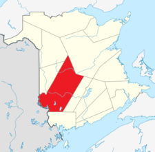
York County, New Brunswick
York | |
|---|---|
 Location of York County, New Brunswick | |
| Country | |
| Province | |
| Established | 1785 |
| Area | |
| • Land | 8,136.66 km2 (3,141.58 sq mi) |
| Population | |
| • Total | 97,238 |
| • Density | 12.0/km2 (31/sq mi) |
| • Change 2001-06 | |
| Time zone | UTC-4 (AST) |
| • Summer (DST) | UTC-3 (ADT) |
| Area code | 506 |
| Dwellings | 41,591 |
| Median Income* | $50,524 |
| |

York County (2011 population 97,238) is located in west-central New Brunswick, Canada. The county contains the provincial capital, Fredericton. Outside the city, farming and forestry are two major industries in the county, which is bisected by the Saint John River. The Southwest Miramichi River flows through the northern section of the county.
History
York County was established in 1785, named after the second son of King George III, Prince Frederick-Augustus (1763-1827), who was made Duke of York in 1784. By 1831,[3] the top half became so full with settlers, due to the rich soil in the region, that it was split off to become Carleton County.[4]
Census subdivisions
Communities
There are ten incorporated municipalities within York County (listed by 2011 population counts and national census rankings):[1][2]
| Official Name | Status | Area km2 | Population | Census Ranking |
|---|---|---|---|---|
| Fredericton | City | 130.68 | 56,224 | 90 of 5,008 |
| New Maryland | Village | 21.23 | 4,232 | 791 of 5,008 |
| Upper Miramichi | Rural community | 1,835.01 | 2,373 | 1,180 of 5,008 |
| McAdam | Village | 14.47 | 1,284 | 1,773 of 5,008 |
| Nackawic | Town | 8.40 | 1,049 | 2,016 of 5,008 |
| Stanley | Village | 17.34 | 419 | 3,234 of 5,008 |
| Canterbury | Village | 5.34 | 331 | 3,527 of 5,008 |
| Harvey | Village | 2.46 | 363 | 3,420 of 5,008 |
| Millville | Village | 12.16 | 307 | 3,612 of 5,008 |
| Meductic | Village | 5.57 | 270 | 3,741 of 5,008 |
Parishes
The county is subdivided into fourteen parishes (listed by 2006 population counts and national census rankings):[1][2]
| Official Name | Status | Area km2 | Population | Census Ranking |
|---|---|---|---|---|
| Kingsclear | Parish | 303.26 | 6,689 | 545 of 5,008 |
| Douglas | Parish | 1446.50 | 5,774 | 609 of 5,008 |
| Saint Marys | Parish | 753.06 | 4,224 | 767 of 5,008 |
| Bright | Parish | 404.00 | 3,159 | 958 of 5,008 |
| New Maryland | Parish | 375.40 | 2,348 | 1,193 of 5,008 |
| Manners Sutton | Parish | 525.47 | 1,863 | 1,394 of 5,008 |
| Stanley | Parish | 2,040.21 | 1,817 | 1,408 of 5,008 |
| Southampton | Parish | 450.05 | 1,601 | 1,535 of 5,008 |
| Queensbury | Parish | 301.22 | 1,215 | 1,811 of 5,008 |
| Prince William | Parish | 287.92 | 879 | 2,234 of 5,008 |
| Canterbury | Parish | 557.22 | 555 | 2,875 of 5,008 |
| Dumfries | Parish | 305.23 | 369 | 3,418 of 5,008 |
| North Lake | Parish | 440.72 | 300 | 3,678 of 5,008 |
| McAdam | Parish | 537.62 | 80 | 4,512 of 5,008 |
First Nations
There are three First Nations reserves in York County (listed by 2006 population counts and national census rankings):[1][2]
| Official Name | Status | Area km2 | Population | Census Ranking |
|---|---|---|---|---|
| Devon 30 | Reserve | 2.73 | 767 | 2,432 of 5,008 |
| Kingsclear 6 | Reserve | 3.73 | 465 | 3,117 of 5,008 |
| St. Mary's 24 | Reserve | 0.01 | 0 | 5,008 of 5,008 |
Unincorporated communities
- Astle
- Beaver Dam
- Burtts Corner
- Cross Creek
- Douglas
- Dumfries
- Durham Bridge
- Forest City
- Fosterville
- Green Mountain
- Hainesville
- Hanwell
- Island View
- Keswick Ridge
- Kingsclear
- Lake George
- Mactaquac
- McGivney
- Napadogan
- Nashwaak Bridge
- Nashwaak Village
- Nasonworth
- North Lake
- Pemberton Ridge
- Penniac
- Pokiok
- Prince William
- Tay Creek
- Taymouth
- Temperance Vale
- York Mills
- Zealand
Demographics
|
Population trend[5]
|
Mother tongue language (2006)[1]
|
Protected areas and attractions
Notable People
See also
References
- ^ a b c d e f 2006 Statistics Canada Community Profile: York County, New Brunswick
- ^ a b c d Statistics Canada Population and dwelling counts, for Canada and census subdivisions (municipalities), 2006 and 2001 censuses - 100% data
- ^ "York County". Where is Home? New Brunswick Communities Past and Present. Provincial Archives of New Brunswick. Retrieved 27 May 2012.
- ^ Wright, Esther Clark (February 1972). "The Distribution". The Loyalists of New Brunswick (2nd. ed.). Canada: Moncton Pub. Co. Ltd. p. 197.
- ^ Statistics Canada: 1996, 2001, 2006 census
External links
