
Zuni Pueblo, New Mexico
Zuni Pueblo, New Mexico | |
|---|---|
.jpg) Zuni Pueblo in 1945 | |
 Location of Zuni Pueblo, New Mexico | |
 Zuni Pueblo Location in the United States  Zuni Pueblo Zuni Pueblo (New Mexico) | |
| Coordinates: 35°4′10″N 108°50′48″W / 35.06944°N 108.84667°W | |
| Country | |
| State | |
| County | McKinley |
| Area | |
| • Total | 12.62 sq mi (32.69 km2) |
| • Land | 12.62 sq mi (32.69 km2) |
| • Water | 0.00 sq mi (0.00 km2) |
| Elevation | 6,293 ft (1,918 m) |
| Population | |
| • Total | 6,176 |
| • Density | 489.27/sq mi (188.91/km2) |
| Time zone | UTC-7 (Mountain (MST)) |
| • Summer (DST) | UTC-6 (MDT) |
| ZIP code | 87327 |
| Area code | 505 |
| FIPS code | 35-86595 |
| GNIS feature ID | 1867391 |
| Website | ashiwi |
Zuni Pueblo (also Zuñi Pueblo, Zuni: Halona Idiwan’a meaning ‘Middle Place’[3]) is a census-designated place (CDP) in McKinley County, New Mexico, United States. The population was 6,302 as of the 2010 Census.[4] It is inhabited largely by members of the Zuni people.
Geography[edit]
According to the United States Census Bureau, the CDP has a total area of 8.8 square miles (23 km2), all land.
A significant landmark of Zuni Pueblo is the Dowa Yalanne, a nearby mountain covering approximately 320 acres (130 ha).[5]
Demographics[edit]
| Census | Pop. | Note | %± |
|---|---|---|---|
| 2020 | 6,176 | — | |
| U.S. Decennial Census[6][2] | |||
As of the census[7] of 2000, there were 6,367 people, 1,488 households, and 1,334 families residing in the CDP. The population density was 720.0 inhabitants per square mile (278.0/km2). There were 1,622 housing units at an average density of 183.4 per square mile (70.8/km2). The racial makeup of the CDP was 97.03% Native American, 2.12% White, 2.01% Hispanic or Latino, 0.03% African American, 0.03% Asian, 0.30% from other races, and 0.49% from two or more races.
There were 1,488 households, out of which 42.1% had children under the age of 18 living with them, 51.1% were married couples living together, 31.7% had a female householder with no husband present, and 10.3% were non-families. 9.0% of all households were made up of individuals, and 1.5% had someone living alone who was 65 years of age or older. The average household size was 4.26 and the average family size was 4.54.
In the CDP, the population was spread out, with 34.7% under the age of 18, 9.8% from 18 to 24, 32.3% from 25 to 44, 16.8% from 45 to 64, and 6.3% who were 65 years of age or older. The median age was 29 years. For every 100 females, there were 92.7 males. For every 100 females age 18 and over, there were 89.2 males.
The median income for a household in the CDP was $22,559, and the median income for a family was $22,067. Males had a median income of $18,345 versus $18,635 for females. The per capita income for the CDP was $6,908. About 40.0% of families and 43.0% of the population were below the poverty line, including 49.7% of those under age 18 and 41.7% of those age 65 or over.
Arts and culture[edit]

Library[edit]
The Zuni Public Library opened in 1975.[8]
Community[edit]
According to Zuni Pueblo's website, "many of Zuni Pueblo’s events are open to the public", and "religious dances and activities" occur in the Middle Village area.[9]
Zuni Pueblo is described as an "artist colony", with the main industry being stone fetish carving, inlay silverwork, pottery, and other artwork.[10]
It is on the Trails of the Ancients Byway, one of the designated New Mexico Scenic Byways.[11]
Education[edit]
Zuni Public Schools, established in 1980, operates schools serving the community. Prior to 1980 it was in the Gallup-McKinley County Schools.[12] Zuni High School is the zoned high school.
St. Anthony School, Zuni (K-8), of the Roman Catholic Diocese of Gallup, is in Zuni Pueblo. The school began operations on September 3, 1923. The Sisters of Saint Francis of Perpetual Adoration operated the school. Its initial enrollment was 43.[13]
Infrastructure[edit]
Tribally-run A:shiwi Transit connects Zuni Pueblo and Black Rock with Gallup.
-
 Zuni 1850 illustration
 -
 First terrace of Zuni in 1879
 -
 Zuni Pueblo, 1873, by Timothy H. O'Sullivan
 -
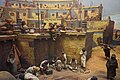 Village Life, Zuni Pueblo, New Mexico


.jpg)
History[edit]
The first contact with Spaniards occurred in 1539 in the ancient village of Hawikku when Esteban, an Arab/Berber of Moroccan origin, entered Zuni territory seeking the fabled "Seven Cities of Cibola" and when Marco da Nizza, an Italian franciscan, reached Zuni Pueblo and called it Cibola.[14]
Halona Pueblo[edit]
Halona Pueblo | |
| |
| Nearest city | Gallup, New Mexico |
|---|---|
| Coordinates | 35°04′04″N 108°49′37″W / 35.06778°N 108.82694°W |
| Area | 1,500 acres (6.1 km2) |
| Built | 1539 |
| NRHP reference No. | 75002066[15] |
| Added to NRHP | February 10, 1975 |
The Halona Pueblo, also known as Zuni Pueblo, is located 36 miles south of Gallup, New Mexico on NM 32 & NM 53. The pueblo dates from before 1539, which was when Europeans first visited New Mexico. It was one of the original six pueblos of the Zuni people. The Fray Marcos de Niza expedition, led by Estevan the Moor, arrived to the area in 1539; most of its party were killed by the Zunis. Coronado's expedition a year later was disappointed not to find great wealth. It was listed on the National Register of Historic Places in 1975.[15]
The Old Zuni Mission, or Nuestra Senora de la Candelaria (Our Lady of the Light), on Old Mission Dr. at 35°04′04″N 108°50′59″W / 35.067782°N 108.849641°W is the building depicted in one photo with NRHP nomination.
Hawikuh Ruins is a National Historic Landmark 12 miles away.
Zuni-Cibola Complex, a National Historic Landmark District, was proposed as a National Park.[16]
See also[edit]
References[edit]
- ^ "ArcGIS REST Services Directory". United States Census Bureau. Retrieved October 12, 2022.
- ^ a b "Census Population API". United States Census Bureau. Retrieved October 12, 2022.
- ^ "Experience Zuni". www.zunitourism.com. Retrieved November 8, 2017.
- ^ "Population estimates, July 1, 2015, (V2015)". www.census.gov. Retrieved May 5, 2016.
- ^ "Dowa Yalanne, or Corn Mountain – New Mexico History". Retrieved October 30, 2023.
- ^ "Census of Population and Housing". Census.gov. Retrieved June 4, 2016.
- ^ "U.S. Census website". United States Census Bureau. Retrieved January 31, 2008.
- ^ "Zuni Public Library." Pueblo of Zuni. Retrieved on April 22, 2009.
- ^ "Visitor Info | Zuni Pueblo MainStreet". zunipueblomainstreet.org. Retrieved October 30, 2023.
- ^ "Zuni Tribe of the Zuni Reservation, New Mexico | Native American Advancement, Initiatives, and Research". naair.arizona.edu. Retrieved October 30, 2023.
- ^ Trail of the Ancients. New Mexico Tourism Department. Retrieved August 14, 2014.
- ^ Ragland, Ruth Ann (June 30, 1980). "Zuni school officials to celebrate creation of state's newest district". The Santa Fe New Mexican. Santa Fe, New Mexico. Associated Press. p. B-2. - Clipping from Newspapers.com.
- ^ "About Us". St. Anthony School, Zuni. Retrieved January 13, 2022.
- ^ Ferguson's, T.J. (1985). A Zuni Atlas. Norman, OK: University of Oklahoma Press.
- ^ a b "National Register Information System". National Register of Historic Places. National Park Service. November 2, 2013.
- ^ Michael McCachren (November 20, 1974). "National Register of Historic Places Inventory/Nomination: Zuni Pueblo / Halona Pueblo". National Park Service. Retrieved July 1, 2019. With accompanying photo from 1973
External links[edit]
- Pueblo of the Zuni - official site
- Zuni Department of Tourism
- Historic photos of Zuni Pueblo, Timothy H. O'Sullivan, photographer
- American Southwest, a National Park Service Discover Our Shared Heritage Travel Itinerary
| Reservations | |
|---|---|
| Pueblos | |
Municipalities and communities of McKinley County, New Mexico, United States | ||
|---|---|---|
| City |  | |
| CDPs |
| |
| Other communities | ||
| Indian reservation | ||
| Footnotes | ‡This populated place also has portions in an adjacent county or counties | |
| Topics | |
|---|---|
| Lists by state |
|
| Lists by insular areas | |
| Lists by associated state | |
| Other areas | |
| Related | |
| International | |
|---|---|
| National | |