
Knocknakilla: Difference between revisions
May09dream (talk | contribs) |
May09dream (talk | contribs) |
||
| Line 25: | Line 25: | ||
==External links== |
==External links== |
||
*[http://www.megalithicireland.com/Knocknakilla%20Stone%20Circle.html Knocknakilla Stone Circle |
*[http://www.megalithicireland.com/Knocknakilla%20Stone%20Circle.html Knocknakilla Stone Circle] at [http://www.megalithicireland.com/index.html MegalithicIreland] |
||
{{European Standing Stones}} |
{{European Standing Stones}} |
||
Revision as of 01:53, 27 November 2010

Knocknakilla's[1] megalithic complex (Grid Ref: W297843) lies between Macroom and Millstreet, in County Cork, Ireland. It is set in blanket peatland on the north-west upper slopes of Musherabeg mountain, and is said to be 3500 years old. The Knocknakilla area is rich with archaeological artefacts and nearby are two cashels, a ringfort, two fulacht fiadh, a possible souterrain and a circular enclosure.[2] Given their relation to both the rising and setting sun, it is thought that they were erected and aligned with purpose. This theory holds that they functioned as calendars and may have been of assistance to early farmers.[3]
The complex includes a Megalithic Complex which is found on a level patch of bogland overlooking a deep valley, and comprises a recumbent stone circle, a radial cairn and two pointy typed portal stones (one of which has fallen), aligned north-northeast to south-southwest. The stone circle is made up of five 1.3- to 1.5-metre-high stones, of which two (the axis and east sidestone) fell sometime in the last 50 years. Only the two northern portal stones and a stone at the west stand today. The stone row, made up of two stones both over 3.5 metres tall, seems to have been aligned on the stone circle, although the stone nearest the circle has fallen, and the remaining stone has a pronounced lean.[4] Three meters away is a 10-stone, 3.5-metre-diameter, radial cairn which was first discovered by Coillte Teoranta in 1970. The upright standing stone is 3.7 metres tall, and it leans heavily to the north.
Nearby is a Dolmen consisting of a long flat capstone supported by three upright stones. Further away is a 1.65-metre-high single standing stone. It is northeast-southwest facing, and rectangular in plan. The stone narrows towards the top, and is leaning to the northeast.
Gallery
-
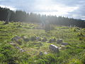 Radial cairn and standing stone at Knocknakilla
 -
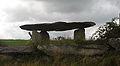 Knocknakilla Dolmen
 -
 Knocknakilla Standing Stone


See also
References
- ^ The word Knocknakilla is derived from the Irish Cnoc na Cille, as 'The Hill of the Church'
- ^ "Knocknakilla". The Megalithic Portal. Retrieved 2008-06-14.
- ^ Cork County Council, Information plaque located near the site.
- ^ "Knocknakilla Recumbent Stone Circle - Co. Cork". Megalithics.com. Retrieved 2008-06-14.
Sources
Denis Power (1997). Archaeological inventory of County Cork, Volume 3: Mid Cork, 9467 ColorBooks. ISBN 0-7076-4933-1