Ghotour Bridge: Difference between revisions
Appearance
Content deleted Content added
No edit summary |
|||
| Line 7: | Line 7: | ||
{{West Azarbaijan Province}} |
{{West Azarbaijan Province}} |
||
{Coord|38.478056|44.768611|display=title|Region:IR}} |
|||
{{coord missing|Iran}} |
|||
38.478056,44.768611 |
|||
[[Category:West Azerbaijan Province]] |
[[Category:West Azerbaijan Province]] |
||
Revision as of 18:24, 14 July 2014

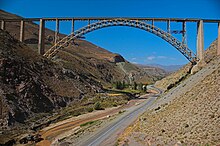
Ghotour Bridge is a railway bridge in Khoy County, West Azarbaijan Province, Iran, over the Ghotour River.[1] It is an arch bridge, was completed in 1970, and has a length of 442.9 m. (1453 ft.) with the largest span being 223.1 m. (732 ft.).[2]
Notes
- ^ "Ghotour Valley Bridge (1970)" Nicolas Janberg's Structurae
- ^ "Ghotour Valley Bridge" American Bridge Net
{Coord|38.478056|44.768611|display=title|Region:IR}}

