
Tumacacori, Arizona: Difference between revisions
Magnolia677 (talk | contribs) Removing unsourced content |
Marine 69-71 (talk | contribs) m I want to a lot of trouble documenting the historic structure. Tag: Reverted |
||
| Line 248: | Line 248: | ||
==Arts and culture== |
==Arts and culture== |
||
Tumacacori National Park Museum, once used by the Franciscan missionaries in the Mission San José de Tumacácori.<ref>{{Cite web|url=https://www.nps.gov/tuma/planyourvisit/visitor-center-and-museum.htm|title=Visitor Center and Museum – Tumacácori National Historical Park (U.S. National Park Service)|website=www.nps.gov}}</ref><ref>[https://americanexpeditioners.com/tumacacori-mission.php Mission Tumacacori]</ref> |
Tumacacori National Park Museum, once used by the Franciscan missionaries in the Mission San José de Tumacácori.<ref>{{Cite web|url=https://www.nps.gov/tuma/planyourvisit/visitor-center-and-museum.htm|title=Visitor Center and Museum – Tumacácori National Historical Park (U.S. National Park Service)|website=www.nps.gov}}</ref><ref>[https://americanexpeditioners.com/tumacacori-mission.php Mission Tumacacori]</ref> |
||
==Historic structures of Tumacacori== |
|||
These are images of historic structures in Tumacacori. Included are images of the inside of the Tumacacori Mission and images of the Cemetery grounds. Also, pictured are artifacts of historical significance on display in the historic Tumacacori National Park Museum, some of which were once used by the Franciscan missionaries in the Mission San José de Tumacácori.<ref>{{Cite web|url=https://www.nps.gov/tuma/planyourvisit/visitor-center-and-museum.htm|title=Visitor Center and Museum – Tumacácori National Historical Park (U.S. National Park Service)|website=www.nps.gov}}</ref><ref>[https://americanexpeditioners.com/tumacacori-mission.php Mission Tumacacori]</ref> |
|||
{{Gallery |
|||
|title=Historic structures in Tumacacori<br>[[File:Tumacacori-Carmen-Tumacacori-A Mission San José de Tumacácori-1691-1.jpg|250px|thumb|center|{{center|'''Mission San José de Tumacácori '''}}]] |
|||
|width=180px |
|||
|height=200px |
|||
|align=center |
|||
|File:Tumacacori-Carmen-Tumacacori-A Mission San José de Tumacácori-1691-1A.jpg|'''Mission San José de Tumacácori ''' |
|||
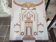
|File:Tumacacori-Carmen-Tumacacori-A Mission San José de Tumacácori-1691-1-Sanctuary.jpg|'''Sanctuary ''' as it once looked |
|||
|File:Tumacacori-Carmen-Tumacacori-A Mission San José de Tumacácori-1691-2-Sanctuary.jpg|'''Sanctuary ''' as it looks now |
|||
|File:Tumacacori-Carmen-Tumacacori-A Mission San José de Tumacácori-1691-2.jpg|Inside '''Mission San José de Tumacácori''' |
|||
|File:Tumacacori-Carmen-Tumacacori-A Mission San José de Tumacácori-1691-5.jpg|Another view inside '''Mission San José de Tumacácori''' |
|||
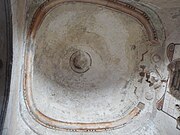
|File:Tumacacori-Carmen-Tumacacori-A Mission San José de Tumacácori-1691-4.jpg| '''Rotunda ''' |
|||
|File:Tumacacori-Carmen-Tumacacori-A Mission San José de Tumacácori-1691-Sacristy.jpg|'''Sacristy ''' |
|||
|File:Tumacacori-Carmen-Tumacacori-A Mission San José de Tumacácori-1691-Fountain.jpg|'''Mission Fountain ''' |
|||
|File:Tumacacori-Carmen-Tumacacori-Cemetery-1691-Mortuary Chapel-2.jpg|'''Mortuary Chapel ''' |
|||
|File:Tumacacori-Carmen-Tumacacori-Cemetery-1691-Mortuary Chapel-3.jpg|Inside the '''Mortuary Chapel''' |
|||
|File:Tumacacori-Carmen-Tumacacori-Cemetery-1691-1.jpg|'''Tumacacori Cemetery''' |
|||
|File:Tumacacori-Carmen-Tumacacori-Cemetery-1691-5.jpg| '''Tumacacori Cemetery graves''' |
|||
|File:Tumacacori-Carmen-Tumacacori-Storage house-1691.jpg|'''Storage house''' |
|||
|File:Tumacacori-Carmen-Tumacacori-Compuerta-1691-2.jpg|'''Compuerta''' |
|||
}} |
|||
===Tumacacori National Park Museum=== |
|||
{{Gallery |
|||
|title=HistoricTumacacori National Park Museum<br>[[File:Tumacacori-Carmen-Tumacácori Museum-1B.jpg|250px|thumb|center|{{center|'''Tumacacori National Park Museum National Historic Landmark Marker'''}}]] |
|||
|width=180px |
|||
|height=200px |
|||
|align=center |
|||
|File:Tumacacori-Carmen-Tumacácori Museum-1A-1937.jpg|'''Tumacacori National Park Museum''' |
|||
|File:Tumacacori-Carmen-Tumacácori Museum-3.jpg|'''Yaqui Traditional Mask''' |
|||
|File:Tumacacori-Carmen-Tumacácori Museum-2 (2).jpg|'''Yaqui Traditional Danse Mask''' |
|||
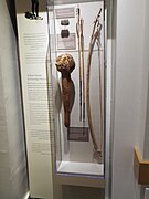
|File:Tumacacori-Carmen-Tumacácori Museum-5.jpg| '''Yaqui weapons''' |
|||
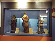
|File:Tumacacori-Carmen-Tumacácori Museum-8.jpg|'''Religious Statues''' |
|||
|File:Tumacacori-Carmen-Tumacácori Museum-4.jpg|'''Press''' for making communion wafers |
|||
|File:Tumacacori-Carmen-Tumacácori Museum-Altar Bell.jpg|'''Altar Bell''' |
|||
|File:Tumacacori-Carmen-Tumacácori Museum-Crucifix.jpg|'''Crucifix''' |
|||
|File:Tumacacori-Carmen-Tumacácori Museum-Evil Eye Pendant.jpg|'''Evil Eye Pendant''' |
|||
|File:Tumacacori-Carmen-Tumacácori Museum-Medallion.jpg|'''Medallion''' |
|||
}} |
|||
==See also== |
==See also== |
||
{{portal|Arizona}} |
{{portal|Arizona}}{{Lists of historic properties}} |
||
* [[List of census-designated places in Arizona]] |
|||
* [[Julie Chen (book artist)]], founder of Flying Fish Press |
|||
* [[List of census-designated places in Arizona]] |
* [[List of census-designated places in Arizona]] |
||
* [[Julie Chen (book artist)]], founder of Flying Fish Press |
* [[Julie Chen (book artist)]], founder of Flying Fish Press |
||
Revision as of 18:12, 20 May 2024
Tumacacori-Carmen, Arizona | |
|---|---|
 Tumacacori mission, 1947. Photo: George A. Grant | |
 Location in Santa Cruz County and the state of Arizona | |
 Tumacacori  Tumacacori | |
| Coordinates: 31°33′40″N 111°2′52″W / 31.56111°N 111.04778°W | |
| Country | |
| State | |
| County | Santa Cruz |
| Area | |
| • Total | 1.91 sq mi (4.96 km2) |
| • Land | 1.91 sq mi (4.95 km2) |
| • Water | 0.00 sq mi (0.00 km2) |
| Population (2020) | |
| • Total | 329 |
| • Density | 172.07/sq mi (66.44/km2) |
| Time zone | UTC-7 (MST (no DST)) |
| ZIP code | 85640[2] |
| Area code | 520 |
| FIPS code | 04-77367 |
Tumacacori (/ˌtuːməˈkɑːkəri/) is an unincorporated community in Santa Cruz County, Arizona, United States, which abuts the community of Carmen. Together, the communities constitute the Tumacacori-Carmen census-designated place (CDP). The population of the CDP was 393 at the 2010 census.[3]
History
Tumacacori is the site of Mission San José de Tumacácori, a Franciscan mission that was built in the late 18th century. It takes its name from an earlier mission site founded by Father Eusebio Kino in 1691, which is on the east side of the Santa Cruz River, south of the national park. This Kino-period mission was founded at an extant native O'odham or Sobaipuri settlement and represents the first mission in southern Arizona, but not the first mission in Arizona. The remains of the native settlement are still extant and have been investigated and reported on by archaeologist Deni Seymour.
The later Franciscan mission, which is now a ruin preserved as Tumacácori National Historical Park, was never rebuilt after being abandoned after repeated Apache raids in the 19th century that killed farmers and ranchers in the area and put a stop to the growth of the area's economy. Nearby Tubac was besieged in 1861.
Geography
According to the United States Census Bureau, the Tumacacori-Carmen CDP has a total area of 2.0 square miles (5.1 km2), all land. The locale is in a valley cut by the Santa Cruz River.
Climate
Tumacacori has a semi-arid climate (Köppen: BSk) with cool winters and hot summers.
| Climate data for Tumacácori National Historical Park, Arizona, 1991–2020 normals, extremes 1946–present | |||||||||||||
|---|---|---|---|---|---|---|---|---|---|---|---|---|---|
| Month | Jan | Feb | Mar | Apr | May | Jun | Jul | Aug | Sep | Oct | Nov | Dec | Year |
| Record high °F (°C) | 89 (32) |
92 (33) |
95 (35) |
100 (38) |
109 (43) |
113 (45) |
113 (45) |
108 (42) |
108 (42) |
104 (40) |
93 (34) |
88 (31) |
113 (45) |
| Mean maximum °F (°C) | 77.4 (25.2) |
79.8 (26.6) |
85.5 (29.7) |
91.6 (33.1) |
98.3 (36.8) |
105.0 (40.6) |
104.2 (40.1) |
100.6 (38.1) |
97.6 (36.4) |
93.3 (34.1) |
84.3 (29.1) |
77.0 (25.0) |
106.2 (41.2) |
| Mean daily maximum °F (°C) | 63.3 (17.4) |
65.7 (18.7) |
71.8 (22.1) |
78.2 (25.7) |
86.0 (30.0) |
95.1 (35.1) |
93.4 (34.1) |
91.2 (32.9) |
88.5 (31.4) |
81.1 (27.3) |
71.3 (21.8) |
62.7 (17.1) |
79.0 (26.1) |
| Daily mean °F (°C) | 47.7 (8.7) |
49.7 (9.8) |
54.9 (12.7) |
60.4 (15.8) |
67.6 (19.8) |
77.1 (25.1) |
80.1 (26.7) |
78.5 (25.8) |
74.1 (23.4) |
64.5 (18.1) |
54.7 (12.6) |
47.2 (8.4) |
63.0 (17.2) |
| Mean daily minimum °F (°C) | 32.0 (0.0) |
33.8 (1.0) |
38.0 (3.3) |
42.5 (5.8) |
49.1 (9.5) |
59.0 (15.0) |
66.8 (19.3) |
65.8 (18.8) |
59.8 (15.4) |
47.9 (8.8) |
38.2 (3.4) |
31.8 (−0.1) |
47.1 (8.4) |
| Mean minimum °F (°C) | 20.2 (−6.6) |
22.6 (−5.2) |
26.2 (−3.2) |
31.2 (−0.4) |
38.5 (3.6) |
48.1 (8.9) |
57.4 (14.1) |
59.0 (15.0) |
49.1 (9.5) |
34.8 (1.6) |
23.7 (−4.6) |
19.8 (−6.8) |
16.8 (−8.4) |
| Record low °F (°C) | 4 (−16) |
9 (−13) |
15 (−9) |
20 (−7) |
28 (−2) |
38 (3) |
42 (6) |
47 (8) |
36 (2) |
18 (−8) |
9 (−13) |
5 (−15) |
4 (−16) |
| Average precipitation inches (mm) | 1.15 (29) |
1.07 (27) |
0.81 (21) |
0.31 (7.9) |
0.17 (4.3) |
0.47 (12) |
3.79 (96) |
3.35 (85) |
1.83 (46) |
1.09 (28) |
0.89 (23) |
1.02 (26) |
15.95 (405) |
| Average snowfall inches (cm) | 0.1 (0.25) |
0.0 (0.0) |
0.0 (0.0) |
0.0 (0.0) |
0.0 (0.0) |
0.0 (0.0) |
0.0 (0.0) |
0.0 (0.0) |
0.0 (0.0) |
0.0 (0.0) |
0.0 (0.0) |
0.0 (0.0) |
0.1 (0.25) |
| Average precipitation days (≥ 0.01 inch) | 3.6 | 3.9 | 2.7 | 1.5 | 0.7 | 1.8 | 11.4 | 10.1 | 5.0 | 2.5 | 2.1 | 3.7 | 49.0 |
| Average snowy days (≥ 0.1 inch) | 0.0 | 0.0 | 0.0 | 0.0 | 0.0 | 0.0 | 0.0 | 0.0 | 0.0 | 0.0 | 0.0 | 0.0 | 0.0 |
| Source: NOAA[4][5] | |||||||||||||
Demographics
| Census | Pop. | Note | %± |
|---|---|---|---|
| 2020 | 329 | — | |
| U.S. Decennial Census[6] | |||
As of the census[7] of 2000, there were 569 people, 223 households, and 152 families residing in the CDP. The population density was 91.6 inhabitants per square mile (35.4/km2). There were 252 housing units at an average density of 40.6 per square mile (15.7/km2). The racial makeup of the CDP was 77.0% White, 0.2% Black or African American, 1.0% Native American, 1.8% Asian, 17.6% from other races, and 2.6% from two or more races. 58.0% of the population were Hispanic or Latino of any race.
There were 223 households, out of which 26.5% had children under the age of 18 living with them, 52.9% were married couples living together, 9.9% had a female householder with no husband present, and 31.8% were non-families. 27.8% of all households were made up of individuals, and 9.9% had someone living alone who was 65 years of age or older. The average household size was 2.55, and the average family size was 3.13.
In the CDP, the population was spread out, with 23.7% under the age of 18, 7.7% from 18 to 24, 26.0% from 25 to 44, 28.6% from 45 to 64, and 13.9% who were 65 years of age or older. The median age was 41 years. For every 100 females, there were 96.9 males. For every 100 females age 18 and over, there were 96.4 males.
The median income for a household in the CDP was $35,938, and the median income for a family was $36,250. Males had a median income of $26,806 versus $18,594 for females. The per capita income for the CDP was $18,607. About 10.1% of families and 10.8% of the population were below the poverty line, including none of those under age 18 and 26.3% of those age 65 or over.
Arts and culture
Tumacacori National Park Museum, once used by the Franciscan missionaries in the Mission San José de Tumacácori.[8][9]
Historic structures of Tumacacori
These are images of historic structures in Tumacacori. Included are images of the inside of the Tumacacori Mission and images of the Cemetery grounds. Also, pictured are artifacts of historical significance on display in the historic Tumacacori National Park Museum, some of which were once used by the Franciscan missionaries in the Mission San José de Tumacácori.[10][11]

-
 Mission San José de Tumacácori
 -
 Sanctuary as it once looked
 -
 Sanctuary as it looks now
 -
 Inside Mission San José de Tumacácori
 -
 Another view inside Mission San José de Tumacácori
 -
 Rotunda
 -
 Sacristy
 -
 Mission Fountain
 -
 Mortuary Chapel
 -
 Inside the Mortuary Chapel
 -
 Tumacacori Cemetery
 -
 Tumacacori Cemetery graves
 -
 Storage house
 -
 Compuerta


Tumacacori National Park Museum

-
 Tumacacori National Park Museum
 -
 Yaqui Traditional Mask
 -
 Yaqui Traditional Danse Mask
 -
 Yaqui weapons
 -
 Religious Statues
 -
 Press for making communion wafers
 -
 Altar Bell
 -
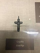 Crucifix
 -
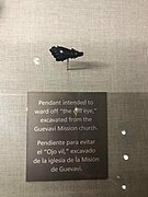 Evil Eye Pendant
 -
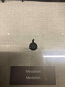 Medallion


.jpg)


See also
| Part of a series of the |
| Cities, towns and CDPs in Arizona with lists and images of historic properties, forts, cemeteries or historic districts |
|---|
 |
- List of census-designated places in Arizona
- Julie Chen (book artist), founder of Flying Fish Press
- List of census-designated places in Arizona
- Julie Chen (book artist), founder of Flying Fish Press
- Mission San José de Tumacácori
- Sonoita Creek
References
- ^ "2020 U.S. Gazetteer Files". United States Census Bureau. Retrieved October 29, 2021.
- ^ "Tumacacori ZIP Code". zipdatamaps.com. 2022. Retrieved November 11, 2022.
- ^ "Geographic Identifiers: 2010 Demographic Profile Data (G001): Tumacacori-Carmen CDP, Arizona". U.S. Census Bureau, American Factfinder. Archived from the original on February 12, 2020. Retrieved December 4, 2012.
- ^ "NOWData – NOAA Online Weather Data". National Oceanic and Atmospheric Administration. Retrieved December 14, 2022.
- ^ "Summary of Monthly Normals 1991–2020". National Oceanic and Atmospheric Administration. Retrieved December 14, 2022.
- ^ "Census of Population and Housing". Census.gov. Retrieved June 4, 2016.
- ^ "U.S. Census website". United States Census Bureau. Retrieved January 31, 2008.
- ^ "Visitor Center and Museum – Tumacácori National Historical Park (U.S. National Park Service)". www.nps.gov.
- ^ Mission Tumacacori
- ^ "Visitor Center and Museum – Tumacácori National Historical Park (U.S. National Park Service)". www.nps.gov.
- ^ Mission Tumacacori
Further reading
- Di Peso, Charles C. The Upper Pima of San Cayetano del Tumacacori: An Archaeohistorical Reconstruction of the Ootam of Pimeria Alta, Dragoon: Amerind Foundation, 1956
- Dobyns, Henry F. Tubac Through Four Centuries: A Historical Resume and Analysis. Prepared for the Arizona State Parks Board March 15, 1959, reformatted by Tubac Presidio State Historical Park, August 1995 and revised. Available online at Tubac Through Four Centuries | Through Our Parents' Eyes
- Doyel, D. E. Excavations in the Middle Santa Cruz River Valley, Southeastern Arizona. Contribution to Highway Salvage Archaeology in Arizona, Number 44. Tucson: Arizona State Museum, U of Arizona, 1977.
- Seymour, Deni J.:
- Piman Settlement Survey in the Middle Santa Cruz River Valley, Santa Cruz County, Arizona, report submitted to Arizona State Parks in fulfillment of survey and planning grant contract requirements, 1993.
- Delicate Diplomacy on a Restless Frontier: Seventeenth-Century Sobaípuri Social And Economic Relations in Northwestern New Spain, Part I. New Mexico Historical Review, Volume 82, no. 4, 2007.
- A Syndetic Approach to Identification of the Historic Mission Site of San Cayetano del Tumacácori. International Journal of Historical Archaeology, Vol. 11(3):269–296, 2007.
- Delicate Diplomacy on a Restless Frontier: Seventeenth-Century Sobaípuri Social And Economic Relations in Northwestern New Spain, Part II. New Mexico Historical Review, Volume 83, no. 2, 2008.
Municipalities and communities of Santa Cruz County, Arizona, United States | ||
|---|---|---|
| City |  | |
| Town | ||
| CDPs | ||
| Populated places | ||
| Ghost towns | ||