
Talk:Southern United States: Difference between revisions
Mphifer254 (talk | contribs) Metros |
|||
| Line 692: | Line 692: | ||
:Except that Northern Virginia is a minority of the area and population of Virginia. It's not a border state, it's Southern. [[User:71.48.140.3|71.48.140.3]] 14:33, 28 April 2007 (UTC) |
:Except that Northern Virginia is a minority of the area and population of Virginia. It's not a border state, it's Southern. [[User:71.48.140.3|71.48.140.3]] 14:33, 28 April 2007 (UTC) |
||
== Metros == |
|||
If the San Antonio metro is going to be removed then the Baltimore metro needs to be removed also because Maryland is hardly ever considered a southern state. I guarantee you that more people will think of San Antonio being more southern than Baltimore.--[[User:Mphifer254|Mphifer254]] 19:02, 29 April 2007 (UTC) |
|||
Revision as of 19:02, 29 April 2007
| This is the talk page for discussing improvements to the Southern United States article. This is not a forum for general discussion of the article's subject. |
Article policies
|
| Find sources: Google (books · news · scholar · free images · WP refs) · FENS · JSTOR · TWL |
| Archives: 1, 2, 3, 4 |
| Southern United States has been listed as one of the good articles under the good article criteria. If you can improve it further, please do so. If it no longer meets these criteria, you can reassess it. | |||||||||||||
| |||||||||||||
| Current status: Good article | |||||||||||||
.svg)

Template:WikiProject Southern United States
About time to Archive?
What do y'all say we "archive" this discussion here and start anew. It is getting verrrrry long! LOL TexasReb 00:02, 25 February 2007 (UTC)
I moved the MD threads to the archive since there seems to be a consensus for now. Let's see how long it takes before someone begins the debate anew. I don't want to touch any of the Kentucky threads, lets let Louisville or Gator tackle those :)
Lasersnake 20:40, 26 February 2007 (UTC)
Lasersnake. I found out why those areas are grey. Those areas are sparsly populated or have no distinct regional dialect. There are regions in the west that are still developing an identity. The PA regions have several dialects and a majority cannot be established.
That's probably a good idea, since it seems as if the debate has died down and the trolls have moved on. It is getting a tad cluttered. --Gator87 00:21, 5 March 2007 (UTC)
Yeah now that those trolls are gone (LOL) maybr we can work on soem more things. 74.128.200.135 03:33, 6 March 2007 (UTC)
I moved most of the threads to the archive since they have been inactive for a while.
Lasersnake 13:44, 6 March 2007 (UTC)
I moved the old Kentucky discussion threads to the archive.
Lasersnake 12:48, 28 March 2007 (UTC)
Florida: Part of "The South"
Based on most of the characteristics people commonly seem to use to define The South (which I could not currently enumerate for you :-), my perception -- and that of lots of people to whom I talk -- is that Florida is not part of The South. Discuss. ;-)
--Baylink 20:26, 6 March 2007 (UTC)
- I strongly disagree. Florida is the South. Just because of cultural variations, you can't exclude it. The northern parts are definitely more Southern in nature than the southern parts, but the state as a whole is more Southern than not. Sure, Miami may not exactly whistle Dixie, but Florida as a whole does. --Stallions2010 23:07, 6 March 2007 (UTC)
As a long-time resident of Florida, I think that we have treated the state well on the new map system and with the writing in the Cultural Variations section as well. I would definitely say that on a whole Florida is definitely not "Southern" by most cultural definitions - and it's really only the North Central and Panhandle regions that are "Southern", it is by no means just Miami that has seen change and immigration. Orlando, Tampa, Daytona Beach, Sarasota, etc. etc. etc. are all Northern/international enclaves and have been for decades in most cases. But geographically what else could Florida possibly be other than Southern? Kind of at an odd position. Culturally it is in about the same position as Maryland, but geography dictates otherwise. It is Southern because of its location and heritage, not in any way because of its modern culture. --Gator87 23:14, 7 March 2007 (UTC)
I think the main notable cultural difference which would keep Florida from being considered "the south" would be the fact that it will NOT rise again.
West Virginia not Confederate
At the risk of stirring up a very touchy hornet's nest, I thought I'd point out that the first map on this page (the "historic southern united states") contains what looks like trans-Allegheny Virginia, along with a caption indicating that this "state" belonged to the Confederacy. I haven't read the entire discussion on this talk page, but from what I have read it seems that nobody has taken issue with this. Strange, considering West Virginia sprang into existence in 1861 [I mean, 1863--see addendum below], and was certainly not a Confederate state! I'd change the map to reflect this if I could (or at the very least to reflect the existence of West Virginia, post-1861), but I unfortunately have no idea how to do that. Anyone else feel like jumping in here?
(By the way, I'm not claiming that West Virginia isn't a southern state, so please don't anyone jump down my throat about that, alright? I agree with whoever it was above who said that culture counts for more than historical geo-political boundaries when it comes to this kind of thing. Of course, looking at it that way, we could come up with another category for western Pennsylvania, West Virginia, southwestern Virginia, and eastern Kentucky called "Northern Appalachia" or "Coal States" or some such thing... But that would probably just start more problems than it would solve.) Buck Mulligan 04:22, 8 March 2007 (UTC)
- To clarify: I'm not saying that West Virginia was never a Confederate state, as my over-zealous post above (wrong date and all) would indicate. I'm saying that the map in question is misleading because it treats trans-Allegheny Virginia as though it were a still-extant state, and so effectively denying the fact that West Virginia even exists, never mind why it came into existence in the first place. Okay, then... Buck Mulligan 05:37, 8 March 2007 (UTC)
The map says that "The states in red were in the Confederacy."
What is now known as West Virginia was part of Virginia until 1863. Virginia was part of the Confederacy in 1861. Therefore from 1861-1863 the region in question was still part of Virginia and thus part of the Confederacy and thus is red on the map. The article has significant content describing the seccession of WV from the rest of VA. Please read the content and see if it discusses the issue to your liking.
Lasersnake 13:40, 8 March 2007 (UTC)
- I read the article before I posted my original message, and I have no problem with what the article has to say about the West Virginia issue. It's the picture that I find misleading. Again, while it's true that the geographical area which eventually became West Virginia did belong to the Confederacy, it's also true that West Virginia the state never did. Anyway, I think the problem can be taken care of with a slight adjustment of the caption, which I will make. Buck Mulligan 17:36, 8 March 2007 (UTC)
>> As I recall, the question of how to "color" (if at all) what is now West Virginia on the "historic map" was one we all had some trouble with. As Laser said, we finally decided to make the map reflect pre-1863 status. Anyway, Buck, the "note" you added does clear things up a bit more. TexasReb 15:19, 10 March 2007 (UTC)
I was thinking about it, and Buck's edits brings up a larger concern. The historic map shows the current US state boundries, except those of WV. Would it be better to use a map that shows the states' and territories' borders as they were in 1860?
Lasersnake 15:54, 12 March 2007 (UTC)
- That sounds like a good idea to me. I noticed that the Confederate States of America page contains a pretty cool animated map that not only reflects such things as the fact that most of the west and midwest consisted of territories rather than states at the time of the Civil War, but also shows very clearly when various states seceded from the union, when they officially became confederate, when they were admitted back into the union, that kind of thing. I must say it's a pretty cool map. Anyway, perhaps we could copy it from them and display it someplace on the Southern U.S. page. On the other hand, this article isn't really supposed to be about the Civil War, per se, so maybe that won't be an idea that agrees with everybody. Still, anyone who's curious ought to go check it out. Buck Mulligan 18:53, 12 March 2007 (UTC)
>> Personally, I strongly side with keeping the historic map the way it is and then perhaps, as Buck suggested, putting another map reflecting 1861 WBTS boundaries elsewhere (Perhaps in the "Civil War" topic). For one thing, when the concept of two maps was proposed and accepted, the idea was to give those states in the Confederacy special recognition as being those which not only truly cemented the idea of "The South" in popular and national mindset, but still today has an emotional meaning for residents within. As well as being the traditional and historic "Dixie." TexasReb 13:26, 13 March 2007 (UTC)
What I am suggesting is not to change any states in the historic definition, just to have the map template be a map of the US in 1860 as opposed to a map of the US in 2007. This means VA/WV would be united, and the Rocky Mountain and SW states would be shown with their territorial boundaries before statehood. This map template would be more historically accurate and wouldn't change the map's content since it was decided that the defintion of the "Historic South" was the Confederacy in 1860.
Lasersnake 17:38, 13 March 2007 (UTC)
>> I understand what you are saying and acknowledge your points, and perhaps I didn't really explain my position well enough. What I meant was that still today, in 2007, the 11 states of the Old Confederacy remain the "traditional and emotional South" in the minds of many. And is what is properly defined by the term "Dixie." (more on that one in another thread). In fact, some scholarly sources retain that basic 11 state definition to deliniate "The South."
>>Too, the map as it is illustrates well the part of the "Geography" section which reads: "The popular definition of the "South" is more informal and is generally associated with those states that seceded during the Civil War to form the Confederate States of America. Those states share commonalities of history and culture that carry on to the present day"
>>For those reasons, to keep a map titled "Historic Southern United States" offsetting the CSA states is valid and appropriate within a present day map of the country. So far as WV goes, I think Buck's qualification explains away any confusion...
>>Of course, something showing the 1861 situation is appropriate, I just believe it should be located elsewhere on the page...perhaps in the Civil War section. TexasReb 12:13, 14 March 2007 (UTC)
OK, I think the reasons for keeping the template for the "Historic South" as a 2007 map are valid. The decision was well thoughtout and as you said, Buck's comment explains the most confusing aspect of the map. Thanks for explaining the reasoning behind the map.
Lasersnake 12:36, 14 March 2007 (UTC)
Slight revision
>>I too made a slight revision on the introduction of the main article. I added "south central" to "southeastern" as to the geographical location of The South. I hope that meets with everyone's approval. If not though, it isnt something I will make an issue over! TexasReb 15:00, 10 March 2007 (UTC)
>>Something kind of interesting I came across yesterday while going thru some files, was a little "survey" Dr. John Shelton Reed took of 68 of his students at UNC at Chapel Hill. They were given a list of the 50 states and asked to answer yes or no to the question "Is this state Southern, all in all?" With certain interesting exceptions, the answers pretty well coorespond to the map we have of the "Modern South." I might add that the published result didn't include the actual affirmative percentages for each individual state (which would have been interesting to see), but rather by a broader classification scale. To wit:
>>Louisiana, Mississippi, Alabama, Georgia, Tennessee, South Carolina and North Carolina were included by "over 75%". Texas, Virginia, Florida, and Kentucky were considered Southern by a majority (over 50%), while Oklahoma, West Virginia, Missouri and Arkansas were accepted by some (Maryland and Delaware didn't register on the "meter"!)
>>Yes, you read right..Arkansas was placed on the "third team" so to speak, and Dr. Reed himself noted this strange anomaly, although he didn't say if he actually asked them about it. (I mean, other than a few Deep South purists out there, I know of few if any definitions that exclude Arkansas from the South). Anyway, this basically informal survey was done in the late 80's or early 90's I think, and the only thing I can figure is that maybe it might have had something to do with negative perceptions of either or both of the Clintons. I don't mean to get political, but I think the theory might have some validity...
>>Oh well, just a note in passing! TexasReb 14:26, 11 March 2007 (UTC)
- It sounds like an interesting study, Texasreb, and if it was conducted after 92, then you might be right about the Clinton thing. But on the other hand, I don't know if we're ever going to get a real consensus around here regarding what counts as a "Southern" state and what doesn't, no matter who's in the White House. Part of it might just be that most of the states in question are so damn big; people from one end of any given state are often very different in their attitudes and lifestyles than people from the other. Northern Virginia, where my family lives, is in some ways (mostly cultural) not much like southern or south-western Virginia. So maybe, given the choice, people would be more likely to say that eastern Arkansas is more southern (drive five minutes out of Memphis and you're in Arkansas, after all) and western Arkansas is more ... What? Western? Anyway, I'm thinking that this kind of feeling is probably what's behind some of the controversy we see around here.
- To put it into a different kind of perspective, all of England and Wales would just about fit into the geographical space occupied by Virginia and Maryland--and yet: if you know anything about the English (and the Welsh), then you know that they have a seemingly endless array of quite distinct accents, with differing vocabularies to go with them, and that they differentiate themselves as people in terms of geographical distinctions that, to a North American, seem almost hilariously minute--the south of England, the west, the south west, the midlands, the northern midlands, the north of England, etc. Hell, people from Cornwall, an English county one square mile smaller than Long Island, have their own language--and not in the way that a dialect can be like a different language; Cornish is totally incomprehensible to an English speaker, and in fact has dialects of its own. And most of Europe is like this. At least eleven seperate languages (not dialects, but languages) are spoken in various regions of the Iberian peninsula, a smaller geographical area than the state of Texas.
- So in a way, it's not too surprising that we'd a have a bit of trouble categorizing a place like Kentucky, straddling two or three cultural/geographic divides as it does. But like you said, this is really just a note in passing. Buck Mulligan 19:55, 12 March 2007 (UTC)
Historic Southern United States map
I think we should get a new map for the Historic Southern United States.
However, I don't think we should change the definition that we have. Our definition is good, but shouldn't we show the United States as it was during the Civil War? West Virginia and Virginia are put together, but that's the only part of the United States that is shown as it was in the 1860's. The map should be compliant with the one at the following link:
http://xroads.virginia.edu/~MAP/TERRITORY/1860map.html
Changes should be made to the western section of the United States. For example, most of Arizona and New Mexico and a small portion of Nevada should be combined into the New Mexico Territory; Kansas and part of Colorado should be combined into the Kansas Territory; etc. These territories don't necessarily have to be labeled, but they should be compliant with the map of the United States as it was in 1860. Also, the caption for the Historic Southern United States should be slightly altered to tell that the map appears as the United States was in 1860, at the onset of the war. A reader would be confused by West Virginia and Virginia being one entity, but the rest of the states that weren't states at the time of the Civil War maintaining their current boundaries.
What do y'all think? --Stallions2010 02:46, 20 March 2007 (UTC)
I raised this same point about a week ago in the thread "West Virginia not Confederate." TexasReb gave a detailed reason for why the current US map, and not the historic one is used. Read it and see what you think. I agree with you that a historic map would be better, but there are good reasons for keeping it the way it is too.
Lasersnake 12:27, 20 March 2007 (UTC)
- I read it. And this is probably the first time ever I'm disagreeing with TexasReb. :) The thing is, we, as people with a large amount of knowledge about the South, understand the historic map. However, readers of this article, who are new and researching this topic, would not. We have explained the reason why West Virginia and Virginia are combined in the caption, but I believe it's much better to change the map to the 1860 boundaries.
The United States has changed quite a lot over the past one and a half centuries, as has its boundaries. We could combine TexasReb's idea with Lasersnake and I's idea. We could have a map of the United States as it was in 1860. The current caption reads:
"Historic Southern United States. The states in red were in the Confederacy and have historically been regarded as "The South" in an emotional and traditional sense. Sometimes they are collectively referred to as "Dixie." Those in stripes were considered "Border" states, and gave varying degrees of support to the Southern cause although they remained in the Union. (Note that this image depicts the original, trans-Allegheny borders of Virginia, and so does not include West Virginia, which seceded in 1863 to join the Union. See image below for post-1863 borders.)"
However, this is confusing because of the last statement. It seems that all borders, not just Virginia's, are those of 1860. With a change, the caption could be slightly altered to convey the idea that all of these states share commonalities to this day, but also that all were in the Confederacy, and therefore, the map is not of the United States as it is now, in 2007.
My ideas may seem a bit confusing. If you don't understand something, please reply to this and ask. Also, Lasersnake, TexasReb, and I are the only ones contributing to this. Anyone else have ideas...? --Stallions2010 23:37, 21 March 2007 (UTC)
- Well, as the guy who started the latest discussion about West Virginia, I think I understand your position, Stallions2010. The trouble is, even the map you linked to is misleading, since it shows West Virginia as a separate state in 1860, which it wasn't. Anyway, I revised my annotation to that map's caption to clarify that the post-1963 thing only refers to the Virginas (and I also reverted the work of Bierstube Katzen Keller, who removed the map altogether—and whose screen name,oddly enough, seems to translate into something like "barroom cat cellar"—though that also meant reverting a legitimate edit concerning Appalachia, but he can always put that back in). I still don't see what the problem with adding another map would be (see my comments above), but, at least in the meantime, hanging onto this one seems like the right thing to do, in my opinion. Buck Mulligan 06:53, 22 March 2007 (UTC)
>>Yeah, Stallions, this DOES seem to be the first time we ever disagreed! :-) But *looking around* it looks as if my comments disappeared! LOL. At any rate, Buck's revision seems to me to clarify even better the Virginia situation. And again (at the risk of sounding like a broken record!) a map of 1861 could be added, I just vote on putting it next to the "Civil War" section. And keep in the original "historic map" the way it is for reasons cited in the earlier thread...and then again on a post which seem to have got 'et up! *grins* TexasReb 12:58, 22 March 2007 (UTC)
Missouri and Kentucky DID Secede From the Union
The Southen States article says that Missouri and Kentucky failed to secede from the union but allowed slaves. Missouri seceded on October 31, 1861 and Kentucky seceded on November 20, 1861. The 12th and 13th stars on the confederate flag represent Missouri and Kentucky as a Confederate State. —The preceding unsigned comment was added by RobertEdmundLee (talk • contribs) 01:59, 21 March 2007 (UTC).
It has stated by quite a few Historians that towards end of the war, (I don't know about Missouri) that with the amancipation of Slavery that Kentucky felt cheated by the Union, and was said to have suceeded. Reguardless I feel that Kentucky's situation was most similar to Tennessee's. 74.128.200.135 02:43, 21 March 2007 (UTC)
Missouri and Kentucky did not officially secede. Though both had rebel governments that supported the Confederate cause and claimed secession (note that the legitimacy and legality of these governments has been fiercely debated by historians, especially in the case of Kentucky), the legitimate governments of those states (meaning the ones that were actually voted into power by the citizens, not a group of slave-owning malcontents) rejected secession. A majority of citizens in both of these states rejected secession. The Confederacy never had any real control over either of these states; I'm not sure about the situation in Missouri, but in Kentucky the Confederate forces never really had control of anything other than the city of Bowling Green, and even then they were essentially forced out of the state by 1862. Both states participated in the Union election of 1864 (which would have been quite impossible for states no longer in the Union), and neither underwent Reconstruction. Furthermore, Louisville and St. Louis - both with large abolitionist German populations - were strongholds of the Union army, and about 65-75% of the Civil War troops in these states fought for the Union army. --Gator87 04:27, 21 March 2007 (UTC)
Yeah I agree with most of what you said reguarding Kentucky's Confederate rebel situation. I only have a little beef with your Statement that Louisville was anywhere near as German as or Unionist as St.Louis and or Cincinnati [1] [2] Even Evansville attracted a larger concentration of Germans during the migration during Louisville. The Galveston and San Antonio areas of Texas also attracted a larger concentration of Germans than Louisville. Richmond (the Capitol of the Confederacy also did too. Now I also must agree that Louisville and Northern Kentucky played major roles in kepping Kentucky in the Union, But Eastern Kentucky like Eastern Tennessee and the Western half of Virginia (which has since formed it's own state) were also key players in very much Union Stronghold's (mainly due to the lack of Slaves). The Appalachain area of Tennessee was also the reason the Tennessee was under Union control not to long after the Southern ends of Kentucky. 74.128.200.135 19:45, 21 March 2007 (UTC)
![[1]](https://upload.wikimedia.org/wikipedia/commons/thumb/9/96/German_population_1872.jpg/492px-German_population_1872.jpg)
![[2]](http://www.cvs.k12.mi.us/dakota/images/africa_map.jpg)
It never ends with you and your knee-jerk reactions, does it? Please tell me where I said that Louisville had AS LARGE a German population as Cincinnati or St. Louis in absolute terms, especially considering that Louisville has never been as large as either city - I said that it had a LARGE German abolitionist population percentage-wise during the Civil War (and after, of course), which it did, as did other border cities in the war. Again, Louisville and St. Louis were two of the major Union strongholds in the Border States and have always had similar (read it: SIMILAR, NOT IDENTICAL) demographics, hence my mentioning of them in the same light since the earlier poster erroneously stated that Missouri and Kentucky did secede. The map at [3], though from the years after the war, clearly shows that areas in N. Kentucky were the only areas in "the South" to attract concentrated German immigration. To quote from [4]: "One of the main reasons for German settlement in Kentucky was the development of manufacturing interests along its Ohio River border, principally in Louisville, Covington and Newport, and to certain settlements of agriculturalist Germans in counties along the northern border of the state. The relatively small number of slaves in counties along Kentucky’s northern border was another reason Germans moved into this part of the Bluegrass State. While slaves accounted for about 20 percent of Kentucky’s total population of 1,150,000 in 1860, they aggregated less than 8 percent of Louisville’s population and less than 2 percent of Covington’s and Newport’s. It is noteworthy that approximately 50 percent of Kentucky’s native-Germans lived in Louisville, and the cities of Covington and Newport (combined) contained almost 20 percent of the Bluegrass State’s German population."
That being said, I am not going to compare Louisville to Confederate cities because Louisville was not a Confederate city. Period, end of discussion. The city was one of Kentucky's hotbeds of abolitionism, largely due to the volumes of German immigrants it attracted, its low slave populations, and ties to Northern markets; it produced notable abolitionists like James Speed. It was not Richmond, nor San Antonio, nor Norfolk, or anything similar, in terms of its Civil War behavior. On Wikipedia it is treated as a quintessential Border city in the war. If you don't like it, I would suggest that you change the content at Louisville in the American Civil War.
And it is truly, absolutely insane to claim that cities like San Antonio and Richmond have the same types of overall German-American heritages as Louisville. They don't. German ancestry, percentages
1. Cincinnati - 19.8%
2. Indianapolis - 16.6%
3. Kansas City - 15.4%
4. Louisville - 15.2%
5. St. Louis - 14.5%
6. San Antonio - 9.0%
7. Nashville - 8.8%
8. Richmond - 6.0%
Not to mention areas of Jefferson County such as St.Matthews and Jeffersontown that are extremely, heavily German (in the range of 25% or so I believe.) But this is pointless, because everybody knows the story of Kentucky and Louisville in the Civil War.
--70.168.88.158 03:45, 22 March 2007 (UTC)
From the way I read it seemed as if you were making the notion that Louisville's German population was the main reason in which the Kentucky did not succeed, which was the case for St. Louis and Missouri.
The fact that you are showing the current demographics without any kind explanation behind them is kind humorous. Why does Louisville currently have a larger percentage of Germans than St. Louis (which without a shadow of a doubt was much more German than it during the migration)? Could it be from the blacks who relocated to the city during the First Great Migration to the North (in which Louisville was bypassed)? St. Louis was indeed a hotbed for poor Southern blacks during this period as were most Midwestern cities. Which is why St. Louis, Cincinnati, Cleaveland, and Indianapolis ECT. have majority black ancestry (within the city).
![[5]](http://www.rollintl.com/roll/gr1900us.gif)
Here's another map detailing German density during this period, as you can see Richmond, San Antonio, Galveston, and Even Memphis (hence their version of German town) are shaded on the highest level of density.
"the exodus of sharecroppers from the land was responsible, too, for a major increase in the black population of southern cities ..." (17) Atlanta, Birmingham, New Orleans, Memphis, Norfolk and Louisville, were a few of the Southern cities which absorbed African-Americans displaced from Southern agriculture."
"Black migrants in Louisville consciously chose to remain in the South because they viewed it as their “Home.” In defining the South as “Home,” Black migrants demonstrated that neither their lives, nor their conceptions of the South were wholly defined by racial oppression or their resistance to it, rather they infused the South with their own meaning. Throughout the period African-American migrants were at the forefront of the city's civil rights movements, their political action was intimately linked to their decision to remain in the South." "The actions of Black migrants in Louisville, whether political, social or economic, are illustrative of the ways in which they claimed the South and “the city” as their own, while working to make it a better place for African-Americans to live."
Luther James Adams, University of Pennsylvania
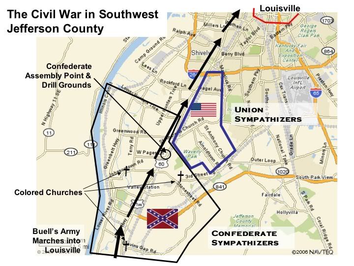
In San Antonio's case, Hispanics (Mexicans) began to lead that city (demographically). Louisville was not a Confederate city, But did have Rebel sections of town. http://img.photobucket.com/albums/v240/Jeff59c/quickies/CivilWarSWCnty.jpg
You continue to clinge to Louisville's relatively low "percentage" of slaves, and claim that it was just "unheard of" in the South. If you had bothered to do a bit more studying you would know that Orleans Parish didn't even have slaves representing 10%[8] of it's population (Jefferson county was 11%). These were urban Southern centers. Both of cities were the two largest Southern cities and were truely the only "large" cities in the South. These cities were not entirely focused on slavery, But at same time, it played a signifigant role in both cities' economies and social climate.
BTW I thought that the Highlands area was the German area of Louisville? Louisvillian 00:58, 24 March 2007 (UTC)
Louisville's German numbers are perfectly valid, in both the inner city and the county as a whole. You will not find another single urban "Southern" county that has county-wide German ancestry in the same range as Jefferson County, KY, except in high-growth Florida counties where most residents are essentially relocated Midwesterners and Northeasterners. Suburban counties are different, because they tend to have lower minority populations and thus tilt the figures somewhat; but look at the urban core counties and find just ONE in "the South" with German ancestry as high as Louisville. Just a single one. I said county-wide, NOT just in reference to the inner cities which, as you stated, are often majority black. Not in Dallas, Houston, San Antonio, Richmond, Nashville, Memphis, Charlotte, etc. etc. will you find similar German ancestry ranges - higher than 15 or so percent. I saved you the trouble, actually:
German ancestry, county-wide
Jackson County, MO: 16.7% German
Jefferson County, KY: 18.2% German
Marion County, IN: 17.0% German
Franklin County, OH: 19.9% German
Hennepin County, MN: 22.8% German
and, on the other hand:
Davidson County, TN: 7.8% German
Shelby County, TN: 5.3% German
Henrico County, VA: 9.1% German
Bexar County, TX (San Antonio): 8.6%
Harris County, TX: 7.2%
Dallas County, TX: 6.6%
Mecklenberg County, NC: 9.5%
Fulton County, GA: 6.0%
Jefferson County, AL: 4.9%
Travis County, TX: 12.0%
Oklahoma County, OK: 12.1%
Pulaski County, AR: 9.0%
This is hardly some random anomaly, and it's also by no means some sort of a "litmus test". However, it disproves the idea that Louisville's intricate German heritage is "common" in the South. Simply not true. A few scattered "Southern" cities may have received somewhat substantial numbers of German immigrants, but it's not the same.
Louisville's relatively low percentages of slaves weren't "unheard" of among slave states - especially for a border city - but they hardly support this notion of the city being "marginally Unionist." You cannot compare Louisville's German populations to other Southern cities consistently across history...the fit just isn't there. On the 1872 map, only the upper rim of the South (or lower rim of the Midwest, depending at how one looks at it) received higher influxes of German, and this it is shaded darker than portions further south. The Germans are relevant here because they tended to despise slavery, given how they viewed it in relation to the serf system of their homeland. The border states generally attracted fewer Germans because of the legality of slavery; when they did settle in these states, the Germans by and large chose cities like St. Louis, Louisville, Covington, etc. for economic opportunities and because of a general identification with the culture.
Yes, Louisville had a Confederate section of town. Yes, Seattle, Washington has a Confederate memorial monument. And? There is no good reason to rewrite history to over-state the importance of a few dissidents. Recognizing the city's Confederate influence would be one thing, but attempting to marginalize its importance/affinity for the Union in the war would be another entirely. --70.168.88.158 07:33, 24 March 2007 (UTC)
Louisville
German - 20%
Black or African American - 19%
Irish - 14%
English - 11%
So now are you disreguarding the actual migration period of Germans into America, or are you basing this argument off of current ancestry demographics that have been munipulated by over a century and half other migrations? Look at the counties that Cleveland, Detroit, Chicago, Indianapolis, Kansas city, and Gary, all of the counties that those cities lie in have a majority black ancestry (stemming from the black migration period). During the actual migration period Galveston, SanAntonio, Austin, Richmond, Oklahoma city, Charleston (SC), ECT. were all German magnets. With the Texas cities however you probably know that they were vying with Hispanics for the top spot. You can also see the clumps suburban counties in Texas that are majority German in ancestry (which where they originally settled). Richmond, Virginia (independent) also recieved a substantial amount of Germans and irish (which was more Midwestern) which can explain why their diocese is more Catholic than ours. Louisville's blacks are also vying with Germans for the top spot with 1% marginal difference. [9]
![[9]](http://130.166.124.2/atlas.us1/US130B.GIF)
[10] Louisville also has a signifigant amount of Scottish -Irish decent that's is typical of the Mid-South. May I also note that Louisville has a higher amount of American first ancesrty than Midwestern cities larger than itself.
![[10]](http://130.166.124.2/atlas.us1/US115B.GIF)
American Ancestry
http://130.166.124.2/atlas.us1/US130.GIF
Percentage http://130.166.124.2/atlas.us1/US130B.GIF
Louisville also does not lack the American ancestry that also tends to characterise the Mid- South.
You are clinging to this "Louisville's relatively low slave percentage of slaves" argument. Again the South did not have only had two truely large cities New Orleans and Louisville (due mostly to their locations). These cities relied on slavery but to a much less degree than rural counties that you continue to compare Louisville to. Jefferson county, KY had slaves represent 11.6% and Orleans Parish, LA has salves make us just 8% of it's population.[11] Despite those relatively low percentages the the numerical slave populations in both cities were the the largest. St. Louis on the otherhand had slaves represent less than 3% of it's population and had less than 10,000 slaves, unlike Louisville which was less than half the size of St. Louis. Baltimore only had slaves represent 6% of it's county population. Again[12] feel free to zoom in on every county you'd like. Your explanation along with my demographic figures showing St. Louis had slaves represent only 2% of it's population might be why St. Louis was much much more of a German magnet than Louisville was. [13] Here are two very good maps that able you to zoom in on the target much like the slavery maps, detailing both German and Irish settlement.You're also claiming that the German migration was only limited to the upper rim of the South, when I just gave you a maps that showed that they were heavily concentrated in the Heart of Texas.
I can't even find a picture let alone a story about the monument, with the exception of an Alabama transplant who complained about the defacing of the monument. In that artucle it states that 11 Confederate veterans were buried in Seattle. We all know that this city had no ties with the Confederacy and wasn't even established,until 1865 ans was unincorporated from 1867- 1869. Louisville on the other had sections of the Community that were Confederate. Here's the article again
[14] "Some excerpts: About Confederate sympathizers: "In 1860 the young men of this section were Southerners and began drilling in order to join the Southern Army. They did their drilling in a field near Pleasure Ridge Park, on Mr Charles Pages' place. The Miller's, Camp's, Shively's, and most of the young men of the leading familys of that section went to the Confederate Camp at Bowling Green. Mr. Thomas Camp had four sons to go and a nephew....Mr. Camp's exhortation to them was never to run; if any of them came back shot in the back they need not come to him for help or expect to be allowed to stay in the house. They went off gaily to the war saying, "We will have the Yankees whipped and back home by Christmas to eat turkey with you." Some of them never got back. The Camp family are mentioned again in this exploit: " During the Civil War many young men wh were inducted by conscription into the Northern army deserted to the South. Some of these men came across the Ohio River near Goshen. In one instance a young boy of fourteen, William Adams, drove a spirited team and springboad wagon from Goshen to Valley Station. His mission was to deliver a grandfathers clock, but in the clocka Southern sympathizer was hiding. The boyt brought him through the back roads to the Camp farm, of whom the young deserter was a relative. He hid in the hills above the farm and the Camps fed him until he could join the Southern army For the Louisville readers: the hills mentioned are visible today, off the Gene Synder freeway, and is that part of the Jefferson County Forest between Pond Creek and Blevins Gap. The map upthread shows the route of the Don Carol's Buells Union army marching to Louisville. The history mentions this march up "Salt River Pike", todays Dixie Highway: "Buell's Army, in his race with Bragg, passed along the pike....they camped one night in that territory between Salt River and Louisville. The next day there were not as many chickens, turkeys, geese, hogs, beehives, rail fences, and cordwood ast there was the day before, and there was some horse trading". ..this bivouac before reaching Louisville was someplace in southwest Jefferson County, off of Dixie Highway. It should be said this area, though pro-South, was not really plantation country, thought there was some large old houses and big pieces of property, like this one along the river, on 200 acres (but enlarged later to 1,500 acres)...the Moorman House: [15] The property was worked by slaves. "Mr. Moorman was good to his slaves. He did every thing he could to encourage their legal marriage of slaves. Often he would buy or sell a slave so that the slave could be on the same farm with their legal husband or wife. After the war was over and the slaves where freed the head of each colored family recieved $100.00 to start on. Up until the time of his death, Israel Putnam, son of Alanson, heard from children of these old slaves. The letters came addressed to "Old Marse". There apparently was a rural African-American population in SW Jefferson County into the 20th century. A "Cold. Church" shows on an old 1870s map, at around Pages Lane and 3rd Street Road. The history mentions two others: One of the early colored churches in our community stands at Blevins Gap Road and Orell Road. It will soon be 100 years old. A school for colored children formerly was in the same area. On Johnsontown Road and Mill Creek there stood at one time a church and school for colored folk. It was begun by the slaves and their families. At the end of World War I, it was burned with a firey cross supposedly by the Ku Klux Klan. There is now a good 'hog proof' fence around the plot and it is well kept and mowed by the descendants" Which brings up a question of a "secret history"...what happened to this rural African American population? Where they driven out by racial violence prior to white suburbanization? As Kentucky was a border state and Jefferson County was right on that border, there where Union sympathizers. One pro-union family left Southwest Jefferson County for Indiana for the duration of the war and returned when the war was over. And there was a region of German farmers in Southwest County that where Union sympathizers, shown on the map above: "Mr. Carl Schroerlucke remembers many stories told to him by his mother concerning the Civil War. He said that 50,000 Union soldiers where camped at the Old Folk Home in Shively and around Louisville. Some of the men visited in this German settlement, which was very strong Union. Hannah, Carl's mother, would as ask the little boy what he could possibly do in a battle, and he answered he was needed to beat the drum. One of the Union soldiers by the name of Dickeman visited the farm often, and said he intended to return one tday to live in this valley. From Louisville this army went ot the battle of Shiloh, he was never heard from again and the Friauf's assumed he was kidded. There was a company of 100 men from this Shardine Precinct... So, just as their neighbors further south joined the CSA army, the German farmers formed a company to join the Union. The history also makes passing mention to the depredations of the "guerillas". Kentucky (and Missouri) had quite a few irregulars, actually just plain bandits in many cases, called "guerillas". One famous one operated in the area south and southwest, was captured, and hung out on what is now Dixie Highway... [16]
![[15]](http://www.riverside-landing.org/images/housenew.jpg)
![[16]](http://www.rulen.com/partisan/mundy.jpg)
Sue Mundy (and no he wasn't a girl) Probably not too interesting stuff, unless one is into local history, but for me it was neat to see how this grand epic of our history..The Civil War...played out in this little corner of Kentucky.." Louisvillian 15:46, 24 March 2007 (UTC)
Bexar county, TX- German - 10%
Daidson county, TX- German - 10%
Oklahoma county, OK- German - 13%
Mecklenberg County, NC- German German - 12%
Pulaski County, AR- German - 11%
Travis, County- German - 13%
Cincinnati- German - 29%
St. Louis- German - 27%
BTW here are some different numbers Louisvillian 16:41, 24 March 2007 (UTC)
In the business of reposting pages of arguments verbatim agian, I see, because you posted you first paragraph a day ago, and the Sue Mundy one a few months ago. Again, nobody is going to answer the same arguments 25 times, so keep wasting space here. I have no idea where you got those numbers at the bottom or if you just made them up, but they aren't accurate in the cases of Bexar, Davidson, Oklahoma, Mecklenberg, Pulaski, and Travis counties, where you have over-stated the German percentages. My source is [17], which pulls information directly from the 2000 Census. None of those Midwestern counties that I cited have African American reported as the majority ancestry, but rather as the plurality (meaning the largest individual group, but still not a majority). And as you yourself said, Jefferson County is fairly close to fitting in that mold also - a few percentage points. German immigrants were not, and are not "heavily" concentrated in the heart of Texas - there are plenty there and there was some historical signifiance, but it is by no means "heavy". Florida has far, far larger German ancestry percentages than Texas due to migration.
Scotch-Irish percentages, and Irish percentages? Nothing odd there either (data from [18]:
Percent reporting any Irish ancestry
Jefferson County, KY - 13.1%
Jackson County, MO - 11.4%
Marion County, IN - 10.6%
Hamilton County, OH - 13.6%
St. Louis County, MO - 15.6%
Percent reporting any Scotish-Irish ancestry
Jefferson County, KY - 1.8%
Jackson County, MO - 1.8%
Marion County, IN - 1.3%
Hamilton County, OH - 1.3%
St. Louis County, MO - 1.5%
United States or "American" ancestries tend to be higher, but not enormously significantly so (and it should be noted that only one county in Kentucky has a lower "American" ancestry percentage than Jefferson - Kenton, which as 11.3%):
"Percent reporting any United States or "American" ancestry
Jefferson County, KY - 11.4%
Jackson County, MO - 7.0%
Marion County, IN - 9.5%
Hamilton County, OH - 6.4%
St. Louis County, MO - 5.1%
Obviously, history has changed the immigration picture, especially in Texas which now has Hispanics as a plurality. Regardless, it is not accurate to say that "Louisville had different migration patterns from Midwestern cities." Other Southern cities may have had somewhat low slave populations, but their modern day demographics are different. Again, you have not, and you will not find a single one with those percentages (close to 20%) of German ancestry - outside of some counties in Florida.
Seattle does have a Confederate monument - [19]. So does St. Louis - [20], so does Kansas City - [21] , and so does Baltimore - [22]. I will repeat myself for the 50th time about this Confederate monument which, again, is about to be converted to one also honoring Union soldiers due to general outrage in the city: And??? It shows that Louisville had (and unfortunately, still has) Confederate sympathizers. Nothing else. They existed in other border cities as well and, in some cases, in pockets far outside of the South. It is not a litmus test for a city's status before or after the Civil war. As the topic below is discussing, Confederate flags can even be found in rural parts of states like Pennsylvania - simple presence of these things does not define a city's character.
If we're talking about the heritage of the Civil War, it is interesting to note that Kentucky is not among the list of states with state-supported Confederate license plates issued by the Sons of Confederate Veterans group, which both Tennessee and Virginia have. That's certainly not some "litmus test" either, but it's interesting.
--70.168.88.158 18:30, 24 March 2007 (UTC)
LMAO you never responded/refuted this source along with most of my other ones. If I can recall you were stating that Louisville was just a Union city and what so a friend sent me these excerts, I post them and you reply with absolutely nothing , and changed the subject back into rather or not to put a star next to Louisville [23] LOL will these assertions of you countering all/most/ or even half of my sources ever end? The old debate is all in the archives for all to view.
[24] This site designed for U.S. ancestry is where I got those numbers from. I meant to say that African Amercians made up the largest ancestry group, rather than the majority. As far as Texas goes yes Germans were heavily concentrated in the Central Region of the state, and I have given 3 maps detailing this [25] [26] [27]. It seems as though you are still ignoring the more 150 years of migrations that this nation has had and how it affected these cities demographics since the German migration. Just look at the Great Lake cities/counties and you see that the largest ancestry their are african americans, due to the Great Migration.
American
Louisville 11.3
Nashville- 11.9
Knoxville- 15.7
Lexington- 11.7
Chatanooga- 16.7
Richmond- 15%
This was the area where American ancestry was the most concentrated
English
Louisville- 10
Nashville- 9.4
Chatanooga- 9.8
Lexington 12.4
Knoxville- 12.1
Richmond is 11.2% Irish Virginia Beach is 12.4% Irish
(all of these are going by your source) With just about every major Virginia city being independent, you can't really compare them to the counties, But just with common sense you can see that these areas in generally are highly German and are or are almost on par with Louisville. Making reference to my sources (which actually show German figures higher in just about every city) The Old city is broken down by ancestry in this order. Black or African American - 33%
German- 16%
Irish - 12%
English - 8%
Richmond, VA German 15%
Knox county- German 12%
Virginia Beach German 14%
It should also be interesting to note that St. Benard Parish (next to New Orleans) is 17% German, and that area has the heaviest concentration of Catholics in the nation. Which is also interesting "religious denomination", we both know that quite a few Southern cities are Catholic, ( and quite a few more Catholic than Louisville) but there is not a single Midwestern city with a Baptist population that matches that of Louisville [28] or other Southern cities.
![[28]](http://www.valpo.edu/geomet/pics/geo200/religion/baptist.gif)
As far as county goes well no, with Richmond being an independent we can't really do that, But Richmond is 15% German.
If you want to talk Civil War than it's interesting to note that there are over 70 Confederate monuments in Kentucky while compared to only 2 Union monument. It should also be interesting to note that Louisville for the past 100 years has only had one Civil War monument and that one was honoring the Confederacy. While St. Louis, Cincinnati, Seattle have all had Union monuments before or around the same time the Confederate monument went up. Louisville after a century has decided to honor the Union as well, bringing the state total to LOL 3. Kansas city- "15 Confederate prisoners of war who died in Kansas City" [29] Louisvillian 18:55, 25 March 2007 (UTC)
Thanks for not generating a single Southern city with the modern-day ancestry mixes of Louisville. As I said, it won't be found outside of Florida (or perhaps Northern Virginia, which usually isn't considered "Southern" either.)
In any event, before you went into one of your scripted-and-rehearsed tangents because somebody *dared* compare Louisville to another border city (imagine that!), this discussion was about the status of KY and MO in the Civil War. And yes, people know that the state of Kentucky, which received influxes of Confederate veterans, realigned somewhat with the South after the war. That was resolved. No historians, none at all, question the status of Louisville either, or the amount of Confederate sentiment in the city. Thus, I'm still not sure what we're attempting to show with the Confederate monument, which only survived to modern times because of a rather vocal minority - and it barely survived even then, and only in a reduced form after it was almost bulldozed to make way for a road (hardly sounds like proper treatment of a "city treasure", does it?) It's a laughable attempt to overplay the extent of Confederate sentiment in this city, as Confederate monuments are found in about every border city - and even an odd location such as Seattle - and it's about to be converted in any event. People have been calling for the monument to be removed for the last 50 years, and anybody from the area knows that quite well. It is not a litmus test. --70.168.88.158 22:42, 25 March 2007 (UTC)
UUHHH last time I checked Richmond and Virginia Beach were Southern cities, and I have yet to hear those cities being grouped in the NOVA area of the state. I know that Louisville has similarities with St. Louis, and an older regional bond with Baltimore, But those cities have always kind of edged away with the South (especially St.Louis) unlike Louisville. From your source it also contradicts the notion that St. Louis county is of majority German ancestry, But unlike other Midwestern cities (their county's) St. Louis has a majority black ancestry (rather than having them make up the largest percentage) that has only gained during the Great Migration North, in which Louisville like other Southern cities lost black population. However I'm not going to get back into that right now. On Kentucky recieving an influx of Confederate veterans, UUUHHHH when? I have heard from quite a few historians however a theory that a good section of Kentucky's Confederates moved further South earlier in war which weakened the numbers latter estimated. I have a heard believing this Southern propaganda crap, that was forced onto Kentuckians, as some have attempted to argue. As far as the Confederate license plate dispute I have just did a search could come across no such conflict (in Kentucky) I did however see two seperate articles reguarding Maryland and Virginia and which two state judges found it uncounstitutional to can the license plate. On the Louisville's Confederate monument and it's destruction goes, It's the first and largest (state) Civil War Monument standing in the citiy's first suburb, despite a few poltical agendas to get rid of it apparently a great deal of public opinion was against the proposed action and was able to override it. Does that public opinion stand for anything to you? Apparently not! Anyway I see you're trying to get this article back on track so do so. Louisvillian 02:08, 26 March 2007 (UTC)
Pennsylvania
Just wanna get this out there. Even though Pennsylvania is not geographically considered to be part of the South, I would have to say that southern Pa in towns like Chambersburg, Pa and Fayetteville, Pa are largely influenced by the Southern culture; for example the Confederate Flag is often flown outside of some houses and at some sporting events. I know that it is north of the traditional south, but in culture I would say that it could be influenced to some degree by the south. You could possibly stripe it on the map of modern definition. --Wikihermit 23:21, 22 March 2007 (UTC)
- I think that's stretching it, for a couple of reasons. First, you may have noticed a certain amount of discord around here concerning the status of "border states." Pennsylvania, on the other hand, borders a border state. The other issue is just practical: If you think about it, just about anywhere you go you're going to find elements of what you're calling "Southern culture," but I'm not sure that's even the right word for it. Most folks I know would just say what you're seeing is a good ol' boy thing, which you'll find everywhere. A few years back, I was at a wedding in Little Falls, a little town in upstate NY, and let me tell you, that bunch was about as "good ol' boy" as anything I've seen back in Virginia (apart from that odd Rachel Ray accent that everyone has). But nobody's going to be adding New York to our list anytime soon, I'm pretty sure.
- As far as southern influence goes, you're probably right that the south influences the way people in the rest of the country behave, but then again, this page isn't called "Places Influenced by the Southern United States." I'll admit I'm a bit mystified when I see the confederate flag being flown in places like Pennsylvania (and yeah, I've seen it too), but I've seen stranger things—that very flag being worn on t-shirts and jacket way up in Montreal, where I now live, for instance (!!!). When I'm in a good mood I kind of just raise an eyebrow at that sort of thing; when I'm not, I just want to shake some sense into these people. I mean, really... But flying (or wearing) a flag doesn't make you southern, any more than wearing pants fifteen sizes too big and saying things like "yo" and "nigga" makes you ghetto.
- My feeling—and, as always, I hope anyone who feels differently will chime in—is that, if anything, the Pennsylvania page might benefit some from this insight into the Pennsylvanian character, but the Southern U.S. page is pretty well complete. Buck Mulligan 04:28, 23 March 2007 (UTC)
Calling PA "Southern" would be a big stretch. Alot of the cultural traits you talk about fall more under the label of "Appalachian," of which a huge chuck of PA is part. Interestingly enough, the great migration of people to the Southern Highlands came through PA so there is great continuity between rural PA and the rural mountain south. The line between Southern culture and Appalachian culture is hard to determine. In the opinions of many, they are one in the same. Some say to be part of Appalachia, you have to part of the South. I personally, think this opinion is too narrow. There are alot of similarities between the various Appalachian portions of the Eastern States, whether Northern, Southern, or border that justify a common grouping.
Lasersnake 12:49, 23 March 2007 (UTC)
>>I agree 100% here. Intending no disrespect toward the original poster, the fact there may be some Confederate Flags displayed in southern parts of Pennsylvania is hardly indicitive of the area being influenced by Southern culture. As Buck noted, Battle Flags can be found in some form or fashion in most parts of the country (and apparently in Canada! LOL). In my own travels out of the South, I have run across the same thing and in 99% of the cases when I inquired about it, it was indeed more of a good ol' boy type thing, or "Dukes of Hazzard", or just because they thought it looked cool! LOL In almost none of them was there anything mentioned about an historical context or true emotional attachment to Southern culture, the exceptions expectedly being a handful who were displaced Southerners!
>>Anyway, again as mentioned, there are probably few places that don't contain some elements of Southern culture. The extreme southern parts of Illinois, Indiana and Ohio particularly come to mind...as does (mentioned in the article, in fact)the area around Bakersfield, California which was settled by a lot of depression era Texans, Okies and Arkies. If we were to start stiping every place so impacted, then we would have half the country looking like a candy cane!
>>We've pretty well defined the South and border South, and I personally can't see anything we could, should, or need to add to it. TexasReb 12:59, 23 March 2007 (UTC)
I don't think would need to be adding states like Ohio, Pennslvania, New Jersey, Indiana, and Illinois on the map.
Confused
hi i think you made a mistake b/c i see on the page that you have maryland + pennsylvania + delaware as southern states. i guess no one noticed it. just wanted to tell you, well okay thanks i'll fix it for you haha wrong states —The preceding unsigned comment was added by 129.174.73.90 (talk) 05:05, 6 April 2007 (UTC).
>>LOL I am a little confused myself on what is being said. Far as I know, Pennsylvania was never striped. Now, Delaware and Maryland are, largely because the U.S. Census Bureau includes them in their definition of "The South" so therefore they fit the criteria for the defintion of those states so "colored"...which is being "sometimes/occasionally considered Southern", whether or not most in the other Southern states agree or not. TexasReb 12:06, 6 April 2007 (UTC)
Wait, what? Maryland's not part of the South...
>>Personally, I agree with you on a gut level. BUT, as has been pointed out many times and in many places in the present discussion thread and in the one archived, a FEW sources (notably the U.S. Census Bureau) counts them as part of the South. Therefore, Maryland (along with Delaware) fits the criteria for being stripped on the map as "Sometimes/Occasionally" considered Southern. TexasReb 12:22, 28 April 2007 (UTC)
Dixie
>>There is something I have been thinking about lately and want to run it past my fellow editors. It concerns the Wikipedia article on "Dixie." There is a textual reference and connecting link to it in the Southern United States piece, but the former really contains very little beyond a bit of history on the song by the same name. This seems a bit out of joint, since while the article here refers to Dixie often being a synonym for the traditional South, nothing is said there which clarifies or expounds on that truism. Do y'all think that maybe we might begin to "flesh out" the other to reflect such?
>>First of all, of course, we would have to mostly agree (just as we finally did on the maps here! LOL) on just exactly "Where is Dixie?" Historically, traditionally, and properly speaking -- and any dictionary backs it up -- it is the 11 states of the Old Confederacy. YET...over the years the term has evolved somewhat in popular mindset into something a bit more defined by perceptions of where the image of "moonlight and magnolias" are very rooted in reality, and where Old South and Confederate traditions live most strongly and are most widely celebrated. In other words, more limited than the South itself and with more mecurical boundaries. The easy deliniations are places like west Texas, northern Virginia and a good part of Florida. Strictly speaking, they are all a part of Dixie, but could they really be included anymore?
>>Let me emphasize the above point by referring to the one of the above I know most about: West Texas. In doing research and going thru old newspapers and such, it was not uncommon at all, up until the mid-1900's at least, for the term "Dixie" to be used quite frequently in business listings or attached to sporting events in that area. The reason being, quite simply, the settlers to the area came from East Texas and other parts of the South, and they (many being Confederate soldiers) and their descendants brought with them that mindset that they were as much Dixie as anybody. Over the years, for one reason or another, that faded, so that now, as John Shelton Reed once put it, somewhat sadly, that the term "Dixie" in far western parts of the South has no more currency than it does in Iowa (that of course, is a bit of exaggeration...but the main point is valid).
>>Anyway, what do you all think about maybe bringing the Dixie article up to snuff, starting with a little sharing and opinions on defining it (that is, in a modern day context...we know what it is historically).
>>By the way, when I mentioned the only thing contained in the article now is song-related, I didnt mean to imply there was anything wrong with that, as I plan on doing a little expanding on that particular facet of Dixie myself. In fact, I once wrote a three-part article on the history of the song from its origins to its modern day useage. If any of you are interested in reading it, here is the URL: http://usads.ms11.net/dixie.html (this goes to Part I. The links to the next segments are contained at the end of the piece itself). TexasReb 13:23, 6 April 2007 (UTC)
Map in the Politics Section
What the hell, that thing looks ridiculous. Look, we can include Maryland and Delaware as being "part of the South" to humor those not living in reality, but only on a token basis. We're not actually supposed to try and integrate the two states into Southern society when they really don't belong!
That being said, the map of Southern electoral votes is completely absurd. You've got this big red mass with a tiny little speck of blue at the top that obviously doesn't belong, but we're just going to pretend like Maryland and Delaware aren't two of the most heavily Democratic states in the whole damn country.
Now, let's see, politically, who would be a closer match to Maryland and Delaware? Why, Pennsylvania, New York, New Jersey, Illinois, Massachusetts, Connecticut, Rhode Island...
Oh, all Northern states.
Like I said, I'll pretend, for the sake of mollifying the hard-liners, that Maryland and Delaware are "border states." Everyone knows, though, that they're actually not, and including them in an article about Southern politics, when their own political sentiments are so flagrantly Northern, is silly. Somebody please fix or remove this map, as it's misleading.
Nanaszczebrzeszyn 16:21, 12 April 2007 (UTC)Nanaszczebrzeszyn
- Whoahhhhh there, buddy--take a deep breath and relax. If you've looked at the rest of this talk page then you already know that major changes to the article, especially when they have to do with what is and isn't going to be included in the South, tend to require a heck of a lot of talking-through. Now, let's have a look at what you're saying...
- Basically, you seem to think that, because most of the South leans rightward, politically, while Maryland and Delaware are more left-leaning in their voting records, therefore they're not southern. That's a pretty narrow definition of what southern and what's not, my friend. Suppose Louisiana started voting blue--what then? They're not southern anymore? There's a lot more to being a southerner than voting for the Grand Ol' Party, and showing that the south is a varied and multifaceted place is the whole point of this page. If you want sterotypes, you can check out any number of other websites. Besides which, there are more black people in the south then anyplace else, and they tend to vote blue. So are they not supposed to be southerners anymore, either? If we took what you're saying to it's logical conclusion, then we could put up a map of the "south" that excluded all the counties that vote Democratic... but then we'd have a map that looked like a slice of Swiss cheese.
- Finally, there's nothing "flagrantly northern" about voting blue. People vote Republican up north all the time, and for all kinds of reasons, and people everywhere have a tendency to vote differently depending on whether they're electing somebody at the municipal, state, or federal levels, because different issues come into play. For that matter, southern Democrats and Republicans tend to be quite different from their northern, western, and midwestern counterparts, because--again--they're concerned about different issues. It's a huge country, after all.
- If I'm not speaking for everybody on this issue, I expect we'll hear plenty more about it, but in the meantime I'd ask you to leave the map up there as it is. Buck Mulligan 19:10, 12 April 2007 (UTC)
The "Southerness" of Maryland and Delaware have been discussed ad naseum. Please look at the archived discussion pages. There have been multiple peer reviewed studies presented and debated that indicate that Maryland and Delaware "Sometimes/Occassionaly" can be considered Southern. If you have any new data you would like to present for discussion, feel free.
Lasersnake 12:54, 13 April 2007 (UTC)
The "red vs. blue state" voting pattern should actually be "urban vs. rural areas." If you examine the voting patterns in all states, north, south, midwest, and west, they all exhibt the same pattern; urban areas tend to vote democrat and rural areas tend to vote republican. Maryland is dominated by the population in its central I-95 region for national level politics, and many of the people living in that area are economically tied to the federal government for jobs. Remember, before the expansion of the federal government in the 50's, most of Maryland was rural. It is in their best interest to vote for the party traditionally associated with government spending. Also, unlike most other southern states (with the exception of Georgia through Atlanta), Maryland has a large *middle class* black population. I stress middle class because voting rates tend to increase with income. However, remember it is a winner take all system, where 49% could vote one way and 51% vote another way, and the 51% carries the state. In Maryland's case, a small number of counties tend to vote democrat, but because of their large population (and the county wide winner take all system), democrats win the state (except in local elections). But anyway, check out this map which is a good reflection of the popular vote throughout the country:
http://en.wikipedia.org/wiki/Image:2004_US_elections_purple_counties.png
As far as the map in the politics section goes, in my opinion it is somewhat redundant to show a sea of red, but oh well...
>>So far as the "Modern Definition" map goes, which in turn relates to the "voting patterns map" about the only thing I can add to this particular thread is that I was one of those who, initially, was decidedly against including Delaware at all. And barely accepted Maryland.
>>However, after -- operative term here -- QUITE A BIT of discussion, spanning a goodly length of time, I came to agree with the majority of fellow editors -- all educated and objective when it comes to Southern culture -- in that the fact the U.S. Census Bureau includes them, warranted, as Laser put it, being striped as "Sometimes/Occasionally.
>>I am not going to go over that one again...the issue is settled. MY point here is, I get a little irritated when people come in and start critisizing when it is obvious they haven't read a damn thing previous by way of either the entirety of the present thread, nor that "Archived" I think that is the underlying point both Laser and Buck were making and I back it up 100%
>>Ok..that is my rant for the evening! LOL TexasReb 00:48, 14 April 2007 (UTC)
Actually, I hate to say it, but I think the original poster has in fact read the archive. If you look at the article history, the political map was added by Sunlight07, someone who has been arguing against including Maryland in the article for several months. Is it coincidence that as soon as a person opposed to the inclusion of Maryland posts a map that points out some of its differences from other southern states, another poster from "*Asstree*, AL," who goes to school in D.C. and has been in trouble from Wikipedia before according to his profile, steps in to argue against Maryland's inclusion because of that map? Further, following the IP addresses of the most recent people who have most called for Maryland's removal all point to a single college in the D.C. area, the city where Sunlight07 has stated he goes to school. I may be way off, and if so, I apologize, but it can all be verified in the Archive and using DNSStuff.com. Basically, I believe we have one person who is attempting to assert his will by pretending to be multiple posters.
- Yeah, I looked at his user page and saw that "Asstree, AL" thing, too, so I followed the Google links, and I came up with nothing but blatantly farcical pages. But then again, I (like him) also used to go to a college in the D.C. area, and I knew plenty of folks who'd have been proud of websites like those, if websites as we know them existed back then (gosh... 13 years seems like such a long time, when you look at it that way). So who knows--I'd say a bit of self-parody in one context isn't beyond the pale for somebody who otherwise has strong feelings about what it is to be southern. Hell, I joke about southern, northern, and everything else all the time, but I also take it seriously when it seems like it really matters. But maybe that's giving this guy too much credit. Actually, I'm starting to wonder if he's the same guy whose edit I reverted about three weeks ago after he removed the southern states map (Bierstube Katzen Keller--it's under the talk section about the historic map).
- Anyway, as for him "asserting his will": on this page at least, nobody seems to be able to assert his will unless he can convince other people that what he's talking about makes some kind of sense--which pretty much means he can't just assert his will. And damn, guys, it makes me kind of proud. Civilization in action, you might say. Buck Mulligan 05:34, 14 April 2007 (UTC)
- Now hold on. That would be like saying that Nancy Pelosi, the current Speaker of the House and a Baltimore native who lived in Maryland until she was a grown woman, is a Southerner. Come on. How many people would actually say that?
For that matter, how many people would describe House Majority Whip Steny Hoyer, Senator Barbara Mikulski, or Senator Benjamin Cardin as Southerners? That being said, I'm surprised at the level to which Maryland politicians have suddenly become front-and-center; two Senators, the House Majority Whip, and the Speaker, are all Marylanders by birth. It's pretty cool stuff.
Nanaszczebrzeszyn 22:01, 17 April 2007 (UTC)Nanaszczebrzeszyn
Oh, and P.S., I am not some other user. Because of course, there's only one college in the D.C. area. And it's very small.
++++++++++++++++++++++++++++++++++++++++++ Well, since you said you aren't the other poster, you *must* not be :) But, more to your point, so Jesse Jackson is not southern (born in Greenville, SC), but George W. Bush (born in New Haven, CT) is because of their political views? I'm from Charleston, SC, and, while not politically affiliated, certainly agree with the Dem. party on many issues. Guess I can't be southern either.
- This discussion is getting us nowhere. I really don't care whether you're one person or many people, Nanaszczebrzeszyn. The point is that you can give us examples of southerners you don't think most people would think of as southern until the cows come home, and you're still not contributing any relevant new information to the discussion.
- And anyway, as
Texasrebpointed out: The real political division in the U.S. takes place along urban/rural lines, not state lines. If you think Red = South and Blue = North, then your south includes most of the midwest and west, and your north includes Illinios, Michigan, Minnesotta, and the entire west coast. Pretty nonsensical. - P.S., Good luck with your "Asstree, Alabama" hoax. Buck Mulligan 22:44, 17 April 2007 (UTC)
- (Looks like it was actually an anonymous user, not Texasreb, who posted a link above to the voting patterns map. My bad.)Buck Mulligan 22:49, 17 April 2007 (UTC)
Just because a place is Republican or Democratic doesn't decide if it is in the North or South. New Hampshire and Ohio are both normally Red States, and they are both Northeastern states as well. Although New Hampshire voted Democrat in the 04 election, they probably just didn't like Bush.
++++++++++ One last point; look at the 1996 presedential election: http://en.wikipedia.org/wiki/United_States_presidential_election%2C_1996
You'll note that Maryland wasn't the only southern state to vote democrat. What about 1992? http://en.wikipedia.org/wiki/United_States_presidential_election%2C_1992
How about 1988? http://en.wikipedia.org/wiki/United_States_presidential_election%2C_1988
Note, Maryland voted Republican. 1984? Same (as did everywhere else): http://en.wikipedia.org/wiki/United_States_presidential_election%2C_1984
My point is that the whole media "Red vs. Blue" hype is just that, hype. The so called "division is recent, just the last two elections. States can, and often do, vote for opposite parties each election. Trying to base what is and isn't southern off of two elections doesn't seem to be the best method to me.
- A quick note: This discussion, apart from being futile, is getting very difficult to read. Guys, please sign your posts. You folks who can't, for whatever reason, sign in under a user name, at least come up with some name for yourself and write it at the end of your messages. And please offset your comments from the last comment before yours by using colons. If you don't know what I mean, just hit the "edit" button and look at this comment of mine--it's indented one space, so you know it's me and not a continuation of the last person's thought. This all probably seems very anal-retentive, but it's very annoying to try to figure out who's saying what, otherwise. Thanks.
- That aside, I think we're all in agreement about the larger issue of the political map. Unless our friend from "Asstree" can come up with something relevant to say, it looks like we can put this one to bed. Buck Mulligan 01:00, 18 April 2007 (UTC)
This whole discussion about defining the South on a blue state versus red state basis is COMPLETELY absurd. Just because a state votes Democratic does not mean it is not Southern by any means. Arkansas Democrats virtually swept every state office this year--by landslides, too. I guess this means by some of you peoples' definitions Arkansas is not a Southern state anymore?ArkSoutherner 23:12, 22 April 2007 (UTC)
I would not personally regard either Maryland or Delaware as Southern states. I don't really know how to explain that; they're just not. The Red State/Blue State thing kind of applies, I guess (because none of the Southern states actually vote Blue in presidential elections), but it's more of a cultural thing. Let me put it to you this way: among most of the people I know, the debate is not whether Maryland is a Southern state, but whether Virginia is. Now, I believe that Virginia is part of the South, but many disagree with me. Maryland, on the other hand, is pretty well Northern.
Southern states never vote Democratically is Presidential elections? Bill Clinton won Arkansas, Louisiana, Tennessee, Kentucky, Florida, West Virginia, and Missouri (If you count Missouri as a Southern state.)ArkSoutherner 16:28, 27 April 2007 (UTC)
Map
Any chance the state names could be added to the map? I'm from the UK, my knowledge of US geography isn't that good, and I had to go to another article to find out which states were which. 86.136.199.169 18:53, 21 April 2007 (UTC) 63.101.179.35 06:29, 22 April 2007 (UTC)
>>Hmmmm...not a bad idea! What do y'all think? I never really considered that there are those not from the United States who want to read about our Southland, and do NOT know which states are which....
>>PROBLEM is, as I see it, is how it could be done in a way that could be easily read on the map itself?? It might not be too much a chore to ABBREVIATE within the boundaries of the individual states such something as "TX, MS, TN, NC," etc. BUT...it goes back to square one in that someone might not know what the abbreviations mean! LOL The other possibility is to add them to the captions of the maps theselves...but the hang up there is that the taglines are fairly lengthy anyway and, even if we did, it comes down to that the full state names would be "disassociated" from the map itself!
>>Anyway, I think our English friend has a good idea...I just dont know, right off the bat, how to implement it! I will be thinking on it though...and meanwhile ask the rest of you all to do the same.... TexasReb 11:50, 28 April 2007 (UTC) 15:37, 22 April 2007 (UTC)
- I agree that it's a good idea and yet a difficult one to implement. If you look at [this section] of the United States article, you'll find that it contains a map of the country with all states labeled, but it's also about three times the size of our current maps. Is there some way to shrink down the image as it's displayed on the page, while allowing for it to spring up full-sized when clicked-on? I suppose there must be some way to do this, but I'm a bit computer illiterate, so if other people like the idea, then somebody else will have to put it up there.
- Basically I think that, whatever we decide, we should definitely try to put something fully labeled into the article. It's nice to know that people from other countries are interested in learning something about the South, especially with world political opinion what it is, these days. Buck Mulligan 16:53, 22 April 2007 (UTC)
Basketball College
I understand rivaly but if you are going to include Ky and NC as Basketball states it only makes since to inclue the University of Louisville, they are in the top 20 all time winning, top 5 most NCAA appearances, and Top 10 Most championships. They are a part of Ky's basketball culture (like it or not) and should be included in this context. I readded them and added a reference. 63.101.179.35 02:51, 22 April 2007 (UTC)
Never really thought about Kentucky's best Team 74.128.200.135
- I'm not sure what you meant there but I readded the information about the Louisville Cardinals. In the context of the paragraph it makes perfect sense to included them number 4 in over all ppearances in NCAA (more than Duke) and 2 Championships as Many as Duke and UNC. Leave sports bias at the door.M-BMor 10:02, 23 April 2007 (UTC)
Virginia?
Sorry, but can Virginia really be considered a Southern state? I mean, with Northern Virginia and everything, it doesn't really seem like it makes much sense. I would call Virginia a border state, with the Northern quarter or so being Northern and the southern three quarters or so being Southern. But you can't really say that Loudoun, Fairfax, or Arlington counties are Southern. What does everyone here think?
- We've been through this already, and the answer is yes: Virginia, Maryland, and Kentucky are all southern states on this page (forgive me, folks, if I'm leaving out a state or two). Please have a look at the archived talk page. Buck Mulligan 01:59, 24 April 2007 (UTC)
- Loundon, Fairfax, Arlington, and Prince William do not a northern state make. Most of the state south of Interstate 66 speaks with a southern accent (and even some people north of that line do) and consider themselves southerners. Southern three-quarters of the state = more than enough to make a Southern state. Do transplants to Raleigh, Cary, and Charlotte make North Carolina northern too? 71.48.140.3 03:57, 24 April 2007 (UTC)
Hmm. Kentucky yes, Virginia maybe, Maryland definitely not. Anyone else have thoughts on Virginia? I'm really kind of on the fence. What if we called it a Border State, since it's split the way it is? That would seem to make more sense than labeling the whole state as part of the South.
- If we mark Virginia a "border state" then Florida should be de-colored entirely. Southern culture and dialect is far more present in Virginia than in Florida. The fact that Florida is located in the South doesn't make it southern. —The preceding unsigned comment was added by 71.48.140.3 (talk) 04:01, 24 April 2007 (UTC).
- Um, no Virginia actually borders a Northern state, whereas Florida doesn't. Florida has Georgia and Alabama to its north and the Gulf of Mexico to its south, whereas Virginia shares a Potomac boundary with Maryland.
- Which means absolutely nothing. The South has to end somewhere. Virginia is the South (culturally, linguistically), Maryland is not. Just because a minority of Virginia's population in NoVa doesn't speak with a Southern accent or consider themselves Southern doesn't make Virginia a border state. 71.48.140.3 03:54, 25 April 2007 (UTC)
- This article is about a geographic sub section of the US. Although there is more to the article than that, unless you can point to reliable sources that state that Maryland, Virginia, Kentucky, Florida, and whatever other state you wish to exclude from the article are never considered part of that geographical area, my question is, what is the basis of your argument?
- Agreed with the previous poster...This is a fascinating debate, one that we have had countless times already. I encourage everyone to look in the archived discussion to see all of the data that has already been presented and discussed about what states can be considered "Southern." If anyone wants to present any new data or articles to add to the discussion, feel free. I think at this point anecdontal observations and opinions will not add much to the debate.Lasersnake 12:54, 24 April 2007 (UTC)
- >> Ditto on the comments by Laser and the other poster above. TexasReb 16:13, 24 April 2007 (UTC)
- One more vote for Southern state. ~ (The Rebel At) ~ 21:55, 24 April 2007 (UTC)
- >> Ditto on the comments by Laser and the other poster above. TexasReb 16:13, 24 April 2007 (UTC)
- Sorry, but Virginia is plain not a Southern state. It's partly southern, but the northern half or so is so influenced by Maryland that there is almost no Southern culture left at all. The Southern accent does not pervade there, nor does traditional Southern food. Confederate flags in the area are taboo. It's also worth noting that Northern Virginia gave the Democrats the Governor's Mansion in 2005 and a Senatorial seat in 2006.
- Northern Virginia's Democratic tendencies are meaningless to this discussion. Arkansas is much more so a Democratic-leaning state than Virginia, yet few would argue that it's a border state.71.48.140.3 03:54, 25 April 2007 (UTC)
- Oh, lord. Apart from agreeing with everybody except the previous poster, I want to emphasize my agreement with the point Lasersnake raises regarding the substance of the objection we're seeing. Discussion and dissent are always healthy and welcome, but if somebody's objection amounts to little more than a variation on "awww--c'mon guys, you all know what I mean" then that's not very helpful to anybody. Neither is "I'm sorry, but...this is really the way things are."
- And to whoever just posted the remark about elections: READ THE DISCUSSION THREAD! We've been through all this before, and you don't even have to look in the damn archive! ...Sorry about the tone, guys, but it's hard to keep civil when people just hop into the middle of a discussion when they obviously haven't bothered to read what's been discussed before. Buck Mulligan 00:12, 25 April 2007 (UTC)
- Yeah, but you can't seriously call Northern Virginia part of the South. I mean, hell, there's actually a group of people in the legislature who want NoVa to secede and then be annexed as part of Maryland. This should be a sign to you.
- Maryland and Northern Virginia are part of the South, geographically. You may not consider them to be Southern culturally (but, blanket statements about an entire state are generally fairly ignorant), but that does not change the geography, which is the entire point of this article. As has been pointed out before, North Carolina's major cities are seeing a heavy influx of northerners. Does that make the Triangle no longer part of the South? Maybe culturally, but certainly not geographically. But, so far you have not even given the first bit of evidence to back up the removal of Maryland and Virginia. Again, what is the basis of your argument, other than "I don't like it?"
- Northern Virginia is NOT part of the South; it's nothing but a bunch of Yankees now. It's just not part of the South anymore. And the whole North Carolina argument doesn't work; North Carolina is surrounded by Southern states, while Virginia borders Maryland. This is why West Virginia is also thought of as a border state: it touches Maryland, Ohio, and Pennsylvania.
- But, by your own argument, Virginia is not Southern. Thus, North Carolina is *not* bordered by Southern states on all sides. Thus, North Carolina is a border state. Thus, North Carolina is not part of the South. Thus, South Carolina borders a Northern state, thus it is a border state, thus it is not part of the South. Thus Georgia... Hmmm, where are we going with this? Oh yeah, do some research. I know, it is easier just to give an opinion. Guess that is the burden of the dissenter.
If a state bounds a Northern neighbor (like Virginia) and then sees a sudden influx of population from that Northern neighbor (like Virginia), then it is reasonable to argue that the state in question is a border state (like Virginia).
- "It's nothing but a bunch of yankees now" is not an argument. Neither is "It's just not part of the south anymore." Furthermore, one reason W. Virginia is considered a border state is that it borders the northern states and the midwest, sure. But another reason, one more relevant to the issues covered on this page (and again: READ THE DAMN TALK PAGE, people), is that it split during the civil war and joined the Union.
- Hmmm... now, let's see... where was the capital of the Confederacy located for nearly the entire period of time that there was a Confederacy? Oh yeah: In Richmond, Virginia! How silly of me to forget! So we've got history (CSA), geography (Mason-Dixon line), and culture (no matter what might be happening in NOVA, the entire state--NOVA included--generally has more in common with southern attitudes and culture than it does with New England, The midwest, etc.).
- So once again: Come here with a real argument, and read the talk thread (including the archive). Otherwise you're just wasting everybody's time. Buck Mulligan 02:54, 25 April 2007 (UTC)
- Let me help guide the original poster. Since the main thesis seems to be "Virginia borders Maryland, thus it is not Southern, because Maryland is not Southern," your first burden of proof seems to be proving that Maryland is always considered a Northern state. From there, you can work on Virginia. Until then, you are just giving opinion, and I, and hopefully everyone else, will be silent until you start to *prove* your opinion is true.
- Northern Virginia is full of Marylanders and other transplanted Northerners--I should know, 'cause I'm one of them! I think of Virginia in general as Southern, but most of my Virginia friends don't agree with me...:(. That being said, Northern Virginia is definitely different than the rest of the state. It's not completely Southern like most of VA, but it's not identical to MD either. It really is like a border state--right in between!
Now, speaking of different cultures...I've spend the last few weeks introducing our neighbors to steamed crabs, crab chips, raw oysters, and, of course, scrapple!!! (which they actually liked!) I haven't been to a Waffle House since coming here, but I'm itching to go!
I tried grits (which I'd thought was a type of meat up until last week) and did not like them very much, but I'm told they taste better if you add butter and sugar and things like that. So, I really like VA, especially NOVA, and would definitely agree that it is a border state. It's got just the right mix of North and South to be right for everyone!
Oh, and P.S.: If there's a list of Southern foods or Southern recipes on here, I'd be very grateful to have someone point it out to me. I'd like to try my hand at some true Dixie dishes
- I'm a bit confused... Are you suggesting that Virginians aren't familiar with crabs and raw oysters? I think you may have run into some very unusual Virginians... Why didn't you visit one of the Waffle House locations in Maryland?
- I don't think we have those. I actually had never heard of Waffle House until I came here! (here being NOVA). So embarrassing!
- Sweetie, NOVA is not Tidewater. And while my friends are fantastic, they are seafood-impaired. I mean, I actually had to teach them not to eat the devil. Now, come on, that's pretty bad. And the reaction to oysters was not very positive...<:O, but they liked the crabs a lot!
- Just curious, are you from Tidewater Maryland (Anne Arundel and south, Eastern Shore), Virginia (Hampton Roads, Eastern Shore), or elsewhere? Where were your friends in NOVA born? When I lived in Maryland (Annapolis) and Virginia (Fredericksburg) you could commonly get anything from crabs to frog legs, turtle soup, and gator tail in many seafood joints. BTW, shrimp and grits with corn bread is where its at :)
- Oh, great!!! Well, I'm from Anne Arundel County, and I absolutely love it there! Turtle soup I've heard of (though never had), but frog legs? Gator tail? You must have been eating in some pretty wild places! I didn't know they made that! Did you think that Anne Arundel was the best or what?
Now, most of my NOVA friends are actually from NOVA, which is so weird because it doesn't seem like the place you would actually grow up. Maybe I'm just prejudiced for my state, though :)
I really am going to try grits again. You see, the first time I ate it, no one told me that you're supposed to put things on it, so I ate it plain and thought it was terrible. I really don't see what all the fuss is! But I'm open-minded and really want to experience Southern foods, so please let me know what some are!!! It's soooooo different down here, but I really like it! Plus, people don't notice my accent here as much as they do in the rest of Virginia, so I don't stand out so much. It's really nice to be able to blend in a little!
So, let me know about those Southern foods!!
- To be quite honest, I am surprised you are from Anne Arundel county and that you consider NOVA more "Southern" than home. Edgewater? Mayo? Deale? Shady Side? Heck, Janet Owens, your previous county executive, is the descendant of Benjamin Welch Owens, winner of the Confederate Medal of Honor. There is a statue of him in Shady Side. Taney was from Anne Arundel County... There is a statue in downtown Annapolis recognizing the city's role as a slave port. Things must have changed since I was there last. But, yes, there are Waffle Houses in Maryland. Check out their website. Southern food? Check Wikipedia :)
No, I'm really from there. I grew up in Pasadena and everything. And I knew about the Taney guy, but you're talking about stuff that happened so long ago. I mean, I knew Maryland had slaves and everything, but...eew, that's a weird idea! That's so weird that some people in Maryland supported the South! Now there's kind of a rivalry between North and South, so I don't think Marylanders would support the South today. Not that I don't like it, though :) Oh, and did you know that they don't call dip eggs dip eggs? How odd is that? I was talking with some friends of mine and got so confused!!!
Are you sure about the Waffle House thing, though? Cause I lived in Maryland my whole life and never even knew about them. It was so funny, the first time I saw one I didn't realize they were part of a chain, and I thought it was just this quaint diner or something! I really want to go to one!
- Waffle House update:
Yeah, I just entered in my old zipcode (21122) into the Wafflehouse location-finder, and it said No Results Found!!! Maybe you were wrong about them being in Maryland. But it said on the site that they have some locations in Pennsylvania and Ohio, so maybe it's possible.
- Okay...well, glad to see you're enjoying yourself. And by the way, no, NoVa is not the South.
Well, I mean Robert E. Lee and Stonewall Jackson, the two icons of the South were both from Virginia, and Virginia solidly supported the Confederacy. Virginia deverses to be called a Southern state, and has much stronger Southern ties than Kentucky. (which did not join the Confederacy.)ArkSoutherner 16:23, 27 April 2007 (UTC)
Old South; New Definition
The definition of the "Old South" on the main page has been changed. The old definition included the original slave states among the first 13 (except Delaware). The new definition takes out Maryland and West Virginia (part of VA back in the days of the "Old South") and adds KY, TN, AL, MS, and FL. The new definition does include a reference, some article from 1936 about the emergence of Metro Communities in the South. The old defintion did not a have a citation. The big problem with this revision is the new defintion does the match the wikipage devoted to the "Old South." Unfortunately the "Old South" page lacks references as well. My understanding of the "Old South" was that it refered to the original slave states that were the "seed stock" for the Southern culture that spread to the Gulf and Inland Southern regions. I am going to try to find some good references to back this up. What does everyone else think?Lasersnake 12:55, 27 April 2007 (UTC)
Cool with me.Louisvillian 16:30, 27 April 2007 (UTC)
Well, I went to dictionary.com clicked on "encyclopedia" and typed in "Old South." I found a wonderful article describing the Old South in detail. I was about to copy the URL and post it here when I noticed the source of the infomration..............Wikipedia! Dictionary.com uses wikipedia as its reference source. I found nearly every other reference search result for "old south" went to wikipedia too. We have to be careful folks, apparently we are the standard for information on this topic :) Anyway, I wasn't able to find any good source defining the "Old South" online or in print. I will try to spend some more time next week on this. Hope everyone has better luck than I did.Lasersnake 18:59, 27 April 2007 (UTC)
>>The ONLY problem -- and it is a minor one -- I have with the new definition of "Old South" is that the original source backing it up stems from a school of thought that, later, became a bit discredited. The original thesis was by a man named Howard Odom, and he was the author of "Southern Regions of the United States"...in which he divided "The South" into a "Southeast...Old South" and "Southwest" (The actual state divisions were pretty much covered by the one to which Lazer provided the link).
>>BUT...this was an era when the idea of a "New South" was also taking hold...one defined by economic possibilities, and not culture and history. What it DIDN'T take into account was just how strong the latter two criteia figured in to defining the South.
>>Another way to put it is that it made a PROJECTION that never came to fruition. That is, that the idea of "The South" was mecurical and unimportant and that New Mexico and Arizona would become a part of something unemotionally called the "Southern Region". A modern day analogy, I think, is to try and make the "Sunbelt" a coherent region..."
>>OK..enough of my ramblings. The only thing I would say is that adding East Texas to the definition of Old South only makes sense. The rest of Texas? No. But eastern Texas, in the day, was pure cotton plantation county and pure Lower South. TexasReb 01:10, 28 April 2007 (UTC)
- I strongly disagree with the new definition. The "Old South" should refer to the south as recognized in the 13 colonies. Futher, here is a speech by D.H. Hill of the Army of Northern Virginia delivered in Baltimore that, as far as I know, coined the term "Old South" that contradicts the new definition:
- Further, if you follow one of the links currently on the page (sorry, don't remember which one, but will locate it if need be), you will read the author's opinion that Southern culture was birthed in the Chesapeake, which makes sense, since that is where the first settlements were in the South (i.e. Virginia, which included land south till Florida in the early colonial days, and Maryland, which was also settled mainly by Viginians). Heck, look up the origins of "cracker" and you will see Virginia and Maryland as sources of the word :)
>>The above is a good point, so let me run something past my fellow editors. What if -- again, just a thought -- if another "definition" on the "Other Definintions" in the opening article section were added? That is, something like "Colonial South"...or whatever? Yeah, yeah, I know that this thing has the potential to get totally unwieldy and "other definitions" stretch for miles, BUT I DO think there is something to be said for it. For example, many today think of the Old South being the part of the region at least reasonably settled prior to the WBTS, and where some form of plantation and/or agrarian existence was the norm. On the other hand, sure, there is much to be said about the Old South being what are known in the history books as the "Southern Colonies." (Maryland, Virginia, the Carolinas, and Georgia).
>>Thoughts, y'all...? TexasReb 15:18, 29 April 2007 (UTC) 15:16, 29 April 2007 (UTC)
Virginia
Just wanted to add my two cents to this debate. Historically, there is no question that Virginia was a Southern state. During the Civil War, it was probably the most important state of the Confederacy. Now, as many people have pointed out, things have changed quite drastically since 1865. However, to state that Virginia is "plain not a Southern state" is inaccurate.
The truth of the matter is, Virginia is neither fully Northern nor fully Southern. In the northern part of the state, the considerable influence of Maryland is significant enough to create a very Northern atmosphere. In the southern part of Virginia, the solid Dixie states of Tennessee and North Carolina help to perpetuate the Old Dominion's status as a bastion of conservatism and a full-fledged member of the South.
In other words, Northern Virginia, only a river away from Maryland, has found its traditional culture almost entirely replaced; while Southern Virginia remains much the same as it has been for decades. Virginia is a border state in the truest sense of the phrase: half North, half South, and wedged directly between the two regions. In my mind, that is how it should be treated. —The preceding unsigned comment was added by 71.161.50.176 (talk) 04:09, 28 April 2007 (UTC).
- Except that Northern Virginia is a minority of the area and population of Virginia. It's not a border state, it's Southern. 71.48.140.3 14:33, 28 April 2007 (UTC)
Metros
If the San Antonio metro is going to be removed then the Baltimore metro needs to be removed also because Maryland is hardly ever considered a southern state. I guarantee you that more people will think of San Antonio being more southern than Baltimore.--Mphifer254 19:02, 29 April 2007 (UTC)