San Miguel, Manila: Difference between revisions
No edit summary |
Adding geodata: {{coor title d|14.600|N|121.000|E|type:city_source:GNS-enwiki}} |
||
| Line 31: | Line 31: | ||
{{Manila}} |
{{Manila}} |
||
{{Philippines-geo-stub}} |
{{Philippines-geo-stub}} |
||
{{coor title d|14.600|N|121.000|E|type:city_source:GNS-enwiki}} |
|||
[[Category:Districts of Manila, Philippines]] |
[[Category:Districts of Manila, Philippines]] |
||
Revision as of 15:18, 20 May 2007
 | |
| City | Manila |
|---|---|
| Population (2000) | 16,798 |
| – Density | per km² |
| Area | km² |
| – Barangays | 12 |
| – Cong. Districts | 6th District |
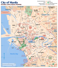
San Miguel district is a primarily middle-class residential area of Manila. Malacañang Palace, the official residence of the President of Republic of the Philippines, is located in San Miguel district. Just outside Malacañang Palace's gates lies Mendiola Street, the avenue where most mass protest actions against the Philippine government are often held. Also on San Miguel district are some colleges and universities that form part of Manila's "University Belt", an area in San Miguel, Quiapo and Sampaloc districts where most of Manila's main colleges and universities are situated. Those educational institutions that are located in San Miguel district include San Beda College, Centro Escolar University, College of the Holy Spirit and La Consolacion College. San Miguel is also the place where the famous San Miguel Beer produced hence the name it is. But the Brewery buildings were demolished after being transferred to the government as property of the Malacanang Palace.

