
Mount Damavand: Difference between revisions
No edit summary |
|||
| Line 67: | Line 67: | ||
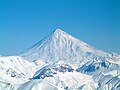
Image:Damavand Mountain.jpg|East View of Damāvand in October |
Image:Damavand Mountain.jpg|East View of Damāvand in October |
||
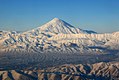
Image:Mount Damavand and birds.jpg|Damāvand Mountain |
Image:Mount Damavand and birds.jpg|Damāvand Mountain |
||
Image:DamavandMountain.jpg|Damaavand Mountain |
|||
Image:DamavandMountain2.jpg|Damaavand Mountain |
|||
</center> |
</center> |
||
</gallery> |
</gallery> |
||
Revision as of 06:31, 13 June 2008
| Mount Damavand | |
|---|---|
| Highest point | |
| Elevation | 5,610 m (18,410 ft) |
Mount Damāvand (Template:PerB) also known as Donbavand, is a dormant volcano and the highest peak in Iran with a special place in the Persian mythology and folklore. Located in the middle Alborz Range, adjacent to Varārū, Sesang, Gol-e Zard and Mīānrūd, it is the highest point in the Middle East and the highest volcano in all of Asia. Though not volcanically active[2], there are fumaroles near the summit crater that deposit sulfur, which were most recently known to be active since July 6, 2007[3]. The mountain is located near the southern coast of the Caspian Sea, in Āmol county, Māzandarān, 66 kilometres (41 miles) northeast of Tehran.
Symbolism and mythology
Damavand is, as any cursory reading of Persian literature will indicate, the Mount Olympus of Persian mythology.[4]
Damāvand is the symbol of Iranian resistance against foreign rule in Persian poetry and literature. In Zoroastrian texts and mythology, the three-headed dragon Aži Dahāka was chained within Mount Damāvand, there to remain until the end of the world. In a later version of the same legend, the tyrant Zahhāk was also chained in a cave somewhere in mount Damāvand after being defeated by Kāveh and Fereydūn. Damāvand is also significant to the Iranian legend of Arash. The mountain is said to hold magical powers in the Šahnameh.
The famous poem Damāvand by Mohammad Taqī Bahār is one of the finest examples of the mountain's place in Persian literature.
The first verse of this poem is:
ای دیو سپید پای در بند
Ay dīve sepīde pāī dar band,
Oh white demon with feet in chains
ای گنبد گیتی ای دماوند
Ay gonbade gītī, ay Damāvand
Oh terrestrial dome, Oh Mount Damāvand
Routes to the summit
The best major settlement for mountain climbers is the new Iranian Mountain Federation Camp in Polour village, located on the south of the mountain.
There are at least 16 known routes [2] to the summit which have different difficulties. Some of them are very dangerous and need rock climbing. The most popular route is the Southern Route which has step stamps and also a camp midway called Bargah Sevom Camp /Shelter [3] at 4220 m (about 13,845 ft). The longest route is the Northeastern and it takes two whole days to reach the summit starting from downhill village of Nāndal and a night stay at Takht-e Fereydoun (elevation 4300 m - about 13,000 ft), a two-story shelter. The western route is famous for its sunset view. Sīmorgh shelter in this route at 4100 m (about 13,500 ft) is a newly constructed shelter with two stories. There is a frozen waterfall / Icefall[4](Persian name Ābshār Yakhī)about 12m tall and the elevation of 5100m is the highest fall in Iran and Middle East.
Geographical location

| Map of central Alborz | Peaks: | 1 Alam-Kuh |
|---|---|---|
 −25 to 500 m (−82 to 1,640 ft) 500 to 1,500 m (1,600 to 4,900 ft) 1,500 to 2,500 m (4,900 to 8,200 ft) 2,500 to 3,500 m (8,200 to 11,500 ft) 3,500 to 4,500 m (11,500 to 14,800 ft) 4,500 to 5,610 m (14,760 to 18,410 ft) |
2 Azad Kuh | 3 Damavand |
| 4 Do Berar | 5 Do Khaharan | |
| 6 Ghal'eh Gardan | 7 Gorg | |
| 8 Kholeno | 9 Mehr Chal | |
| 10 Mishineh Marg | 11 Naz | |
| 12 Shah Alborz | 13 Sialan | |
| 14 Tochal | 15 Varavašt | |
| Rivers: | 0 | |
| 1 Alamut | 2 Chalus | |
| 3 Do Hezar | 4 Haraz | |
| 5 Jajrood | 6 Karaj | |
| 7 Kojoor | 8 Lar | |
| 9 Noor | 10 Sardab | |
| 11 Seh Hazar | 12 Shahrood | |
| Cities: | 1 Amol | |
| 2 Chalus | 3 Karaj | |
| Other: | D Dizin | |
| E Emamzadeh Hashem | K Kandovan Tunnel | |
| * Latyan Dam | ** Lar Dam |
Nomination as National Heritage Site
An anthropologist of Mazandaran Cultural Heritage and Tourism Department, Touba Osanlou, has said that a proposal has been made by a group of Iranian mountaineers to register the highest peak in the Middle East, Mount Damavand as a national heritage site. Mazandaran Cultural Heritage and Tourism Department has accepted the proposal, the Persian daily Jam-e Jam reported. Osanlou noted that the Iranian Cultural Heritage and Tourism Organization is presently in the process of renaming an upcoming ancient festivity after Mount Damavand. "We have proposed Tirgan Festivity, Tabari Nowruz, to be named as Damavand National Day," he added. Tirgan Festivity is held in Amol County’s Rineh region in Mazandaran province. [5]
Damāvand photos
-
 Foot of Damāvand
 -
 Summit Crater of Mt. Damāvand from space.
 -
 Damāvand from space.
 -
 Damāvand Mountain.
 -
Damāvand in summer
-
 Damavand in winter
 -
 East View of Damāvand in October
 -
 Damāvand Mountain
 -
 Damaavand Mountain
 -
 Damaavand Mountain


![[2]](http://www.sogol.com/WHP/IINFO/Ready%20%20INT/DAMAVAND%20MAP2.jpg)
Footnotes
- ^ The 5,610 metre height given here is from the Statistical Centre of Iran, which states that "the highest point in Iran is Mount Damāvand being 5,610 metres high". This elevation is consistent with SRTM data. A 2007 GPS measurement [1] reports a slightly higher elevations, 5623m, but also reports -17m for the nearby Caspian Sea despite its accepted -28m. This suggests that there is slight local geoid inaccuracy built into hand held GPS measurements in this area, and that the official Iranian elevation is accurate. An older elevation, 5,671 m, is not consistent with the above sources and there is no evidence that it is based on any modern measurement, although it is still the most frequently given elevation on the web.
- ^ Template:VNUM
- ^ "Volcanic Hole on Damavand". Retrieved 2007-08-23.
- ^ Milani, A. Lost Wisdom. 2004. Washington. ISBN 0934211906 p.67