
Border: Difference between revisions
No edit summary |
|||
| Line 56: | Line 56: | ||
Image:Town line.JPG|A sign along with a stone marking the border between [[Lexington, Massachusetts]] and [[Burlington, Massachusetts]] on a local road. |
Image:Town line.JPG|A sign along with a stone marking the border between [[Lexington, Massachusetts]] and [[Burlington, Massachusetts]] on a local road. |
||
Image:Puente sobre el Guadiana.JPG|[[Guadiana International Bridge]] in the [[Spain]] - [[Portugal]] border, created by the [[Treaty of Zamora]] in [[1143]]. Is one of the oldest borders in the world. |
Image:Puente sobre el Guadiana.JPG|[[Guadiana International Bridge]] in the [[Spain]] - [[Portugal]] border, created by the [[Treaty of Zamora]] in [[1143]]. Is one of the oldest borders in the world. |
||
Image:Treriks.jpg|The [[Treriksröset]] [[carin]] located at the only point where both [[Sweden]], [[Norway]] and [[Finland]] borders eath other. |
|||
</gallery></center> |
</gallery></center> |
||
Revision as of 20:10, 28 August 2009

Borders define geographic boundaries of political entities or legal jurisdictions, such as governments, states or subnational administrative divisions. They may foster the setting up of buffer zones. Some borders are fully or partially controlled, and may be crossed legally only at designated border checkpoints.
Definitions of borders
In the past many borders were not clearly defined lines, but were neutral zones called marchlands. This has been reflected in recent times with the neutral zones that were set up along part of Saudi Arabia's borders with Kuwait and Iraq (however, these zones no longer exist). In modern times the concept of a marchland has been replaced by that of the clearly defined and demarcated border.
For the purposes of border control, airports and seaports are also classed as borders. Most countries have some form of border control to restrict or limit the movement of people, animals, plants, and goods into or out of the country. Under international law, each country is generally permitted to define the conditions which have to be met by a person to legally cross its borders by its own laws, and to prevent persons from crossing its border when this happens in violation of those laws.
In order to cross borders, the presentation of passports and visas or other appropriate forms of identity document is required by some legal orders. To stay or work within a country's borders aliens (foreign persons) may need special immigration documents or permits that authorise them to do so.
Moving goods across a border often requires the payment of excise tax, often collected by customs officials. Animals (and occasionally humans) moving across borders may need to go into quarantine to prevent the spread of exotic or infectious diseases. Most countries prohibit carrying illegal drugs or endangered animals across their borders. Moving goods, animals or people illegally across a border, without declaring them, seeking permission, or deliberately evading official inspection constitutes smuggling.
Border economics
The presence of borders often fosters certain economic features or anomalies. Wherever two jurisdictions come into contact, special economic opportunities arise for border trade. Smuggling provides a classic case; contrariwise, a border region may flourish on the provision of excise or of import–export services — legal or quasi-legal, corrupt or corruption-free. Different regulations on either side of a border may encourage services to position themselves at or near that border: thus the provision of pornography, of prostitution, of alcohol and/or of narcotics may cluster around borders, city limits, county lines, ports and airports. In a more planned and official context, Special Economic Zones (SEZs) often tend to cluster near borders or ports.
Human economic traffic across borders (apart from kidnapping), may involve mass commuting between workplaces and residential settlements. The removal of internal barriers to commerce, as in France after the French Revolution or in Europe since the 1940s, de-emphasises border-based economic activity and fosters free trade. Euroregions are similar official structures built around commuting across borders.
Border politics
Political borders have a variety of meanings for those whom they affect. Many borders in the world have checkpoints where border control agents inspect those crossing the boundary.
In much of Europe, such controls were abolished by the Schengen Agreement and subsequent European Union legislation. Since the Treaty of Amsterdam, the competence to pass laws on crossing internal and external boders within the European Union and the associated Schengen States (Iceland, Norway, Switzerland, and Liechtenstein) lies exclusively within the jurisdiction of the European Union, except where states have used a specific right to opt-out (United Kingdom and Ireland, which maintain a common travel area amongst themselves). For details, see Schengen Area.
The United States has notably increased measures taken in border control on the Canada–United States border and the United States–Mexico border during its War on Terrorism. The 3600-km (2000-mile) US-Mexico border is probably "the world's longest boundary between a First World and Third World country."[1]
Historic borders such as the Great Wall of China, the Maginot Line, and Hadrian's Wall have played a great many roles and been marked in different ways. While the stone walls, the Great Wall of China and the Roman Hadrian's Wall in Britain had military functions, the entirety of the Roman borders were very porous, a policy which encouraged Roman economic activity with its neighbors[2]. On the other hand, a border like the Maginot Line was entirely military and was meant to prevent any access in what was to be World War II to France by its neighbor, Germany.
Cross-border regions
Macro-regional integration initiatives, such as the European Union and NAFTA, have spurred the establishment of cross-border regions[2]]. These are initiatives driven by local or regional authorities, aimed at dealing with local border-transcending problems such as transport and environmental degradation.[3] Many cross-border regions are also active in encouraging intercultural communication and dialogue as well as cross-border economic development strategies.
In Europe, the European Union provides financial support to cross-border regions via its Interreg programme. The Council of Europe has issued the Outline Convention on Transfrontier Co-operation, providing a legal framework for cross-border co-operation even though it is in practice rarely used by Euroregions.
Border studies
There has been a renaissance in the study of borders during the past two decades, partially resulting from the creation of a counter narrative to notions of a borderless world which have been advanced as part of globalization theory[4]. Examples of recent initiatives are the Border Regions in Transition network of scholars,[5], the International Boundaries Research Unit at the University of Durham[6], the Association of Borderland Scholars in the USA[7], and the founding of smaller border research centres at Nijmegen[8] and Queen's University Belfast[9].
Leading scholars in the contemporary study of borders include Anssi Paasi at the University of Oulu, Henk van Houtum at the Radboud University Nijmegen, Doris Wastl Water at the University of Bern, and David Newman at Ben Gurion University.
Image gallery
The following pictures show in how many different ways international and regional borders can be closed off, monitored, at least marked as such, or simply unremarkable.
- Borders of the World
-
 Border at Tijuana, Mexico and San Ysidro, California, USA. A straight-line border surveyed when the region was thinly populated.
 -
 A militarized frontier: the Berlin Wall used to be one of the most famous guarded borders in the world.
 -
A sign welcoming visitors to the U.S. state of Georgia.
-

-
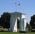 The Peace Arch at the Canada – United States border, the longest common border in the world.
 -
 A sign at the Polish-Czech border near the Králický Sněžník, indicating that the crossing of the border is permitted to only citizens of the European Union and of five more states. When the Schengen rules became applicable there in 2007, the sign became obsolete.
 -
 Several markers designating the border between Nicholas and Greenbrier counties in West Virginia, USA along a secondary road. Notice the older stone survey markers a few meters behind the modern highway sign.
 -

-

-
 A border within a closely built-up area – here near Aachen between Germany and the Netherlands: Germany starts at the blue and yellow signs near the white wall.
 -
 Border between the Netherlands and Belgium next to a street café. Some European borders originate from former aristocratic land ownership limits.
 -
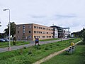 This recently-built building of the Eurode Business Centre straddles the border between the Netherlands and Germany, in Kerkrade and Herzogenrath.
 -
 Italy/Switzerland border stone at Passo San Giacomo. Some borders were broadly defined by treaty, and surveyors would then choose a suitable line on the ground.
 -
 A sign along with a stone marking the border between Lexington, Massachusetts and Burlington, Massachusetts on a local road.
 -
 Guadiana International Bridge in the Spain - Portugal border, created by the Treaty of Zamora in 1143. Is one of the oldest borders in the world.
 -
 The Treriksröset carin located at the only point where both Sweden, Norway and Finland borders eath other.


See also
- Geopolitics
- List of countries that border only one other country
- List of international border rivers
- List of land borders by date of establishment
- List of land border lengths
- List of national border changes since World War I
- List of sets of four countries that border one another
- Political geography
- Political science
References
- ^ Murphy, Cullen. Roman Empire: gold standard of immigration. Los Angeles Times, June 16, 2007 (accessed here June 20, 2007)
- ^ Murphy 2007
- ^ Perkmann, M, Building governance institutions across European borders, Regional Studies, 1999, Vol: 33, Pages: 657 - 667[1]
- ^ D. Newman & A. Paasi, `Fences and neighbours in the post-modern world: boundary narratives in political geography', Progress in Human Geography, 22 (2), 186-207, 1998; D. Newman, `The lines that continue to separate us: Borders in our borderless world’, Progress in Human Geography, Vol 30 (2), 1-19, 2006.
- ^ [http://publicadmin.uvic.ca/brit_ix/index.htm Border Regions in Transition IX Conference, North American and European Border Regions in Comparative Perspective: Markets, States and Border Communities, (January 12-15,2008) Victoria, BC Canada and Bellingham, WA United States.]
- ^ International Boundaries Research Unit, University of Durham.
- ^ Association for Borderland Studies.
- ^ Nijmegen Centre for Border Research.
- ^ Centre for International Borders Research (CIBR) Queen's University Belfast
External links
- Border Stories - A website devoted to stories from both sides of the U.S. Mexico Border
- Confini amministrativi / Riigipiirid - A collection of views of borders from all the world
- Collection of pictures of European borders, mainly intra-Schengen borders
- Institut Européen des Itinéraires Culturels homepage
- Border Ireland - database of activities and publications on cross-border co-operation on the island of Ireland since 1980's
- Talking Borders Queen's University Belfast online audio archive