
Cloud: Difference between revisions
| [pending revision] | [pending revision] |
Tag: section blanking |
|||
| Line 18: | Line 18: | ||
=== Middle clouds (Family B) === |
=== Middle clouds (Family B) === |
||
== ''' |
== '''BALLSACK!!!!''' == |
||
*[[Altostratus cloud|Altostratus]] (As) |
*[[Altostratus cloud|Altostratus]] (As) |
||
Revision as of 13:34, 13 January 2010
| Part of a series on |
| Weather |
|---|
|
|
A cloud is a visible mass of droplets, in other words, little drops of water or frozen crystals suspended in the atmosphere above the surface of the Earth or another planetary body. A cloud is also a visible mass attracted by gravity, such as masses of material in space called interstellar clouds and nebulae. Clouds are studied in the nephology or cloud physics branch of meteorology.
On Earth the condensing substance is typically water vapor, which forms small droplets or ice crystals, typically 0.01 mm (0.00039 in) in diameter. When surrounded by billions of other droplets or crystals they become visible as clouds. Dense deep clouds exhibit a high reflectance (70% to 95%) throughout the visible range of wavelengths. They thus appear white, at least from the top. Cloud droplets tend to scatter light efficiently, so that the intensity of the solar radiation decreases with depth into the gases, hence the gray or even sometimes dark appearance at the cloud base. Thin clouds may appear to have acquired the color of their environment or background and clouds illuminated by non-white light, such as during sunrise or sunset, may appear colored accordingly. Clouds look darker in the near-infrared because water absorbs solar radiation at those wavelengths.
Classification

Cloud types are divided into two general categories: layered and convective. These names distinguish a cloud's altitude. Clouds are classified by the base height, not the cloud top, and bases may differ depending on the geographical zone. This system was proposed in 1802, when it was presented to the Askesian Society by Luke Howard.

High clouds (Family A)
High clouds will form between 10,000 and 25,000 ft (3,000 and 8,000 m) in the polar regions, 16,500 and 40,000 ft (5,000 and 12,000 m) in the temperate regions and 20,000 and 60,000 ft (6,000 and 18,000 m) in the tropical region.[1]
- Cirrocumulus (Cc)
- Cirrus (Ci)
- Cirrostratus (Cs)
Middle clouds (Family B)
BALLSACK!!!!
- Altostratus (As)
- Altocumulus (Ac)
Low clouds (Family C)

These are found up to 6,500 ft (2,000 m)[1] and include the stratus (dense and grey). When stratus clouds contact the ground, they are called fog.
Clouds in Family C include:
- Cumulus[2] (Cu)
- Stratocumulus (Sc)
- Nimbostratus (Ns)
- Stratus (St)
Vertical clouds (Family D)

These clouds can have strong up-currents, rise far above their bases and form at many heights.
Clouds in Family D include:
- Cumulonimbus (associated with heavy precipitation and thunderstorms) (Cb)
- Cumulus (Cu)[3][4]
- Cumulus congestus (TCu)
- Pyrocumulus
Other clouds
A few clouds can be found above the troposphere; these include noctilucent and polar stratospheric clouds (or nacreous clouds), which occur in the mesosphere and stratosphere respectively.
Some clouds form as a consequence of interactions with specific geographical features. Perhaps the strangest geographically-specific cloud in the world is Morning Glory, a rolling cylindrical cloud which appears unpredictably over the Gulf of Carpentaria in Northern Australia. Associated with a powerful "ripple" in the atmosphere, the cloud may be "surfed" in glider aircraft.
Colors


The color of a cloud, as seen from the Earth, tells much about what is going on inside the cloud. Clouds form because warm air tends to absorb water vapor, which is lighter than air, thus helping the mixture to rise. As it rises the air containing it cools and the vapor tends to condense out of the air as micro-droplets. These tiny particles of water are densely packed and sunlight cannot penetrate far into the cloud before it is reflected out, giving a cloud its characteristic white color. As a cloud matures, the dense water droplets may combine to produce larger droplets, which may combine to form droplets large enough to fall as rain. By this process of accumulation, the space between droplets becomes increasingly larger, permitting light to penetrate farther into the cloud. If the cloud is sufficiently large and the droplets within are spaced far enough apart, it may be that a percentage of the light which enters the cloud is not reflected back out before it is absorbed. A simple example of this is being able to see farther in heavy rain than in heavy fog. This process of reflection/absorption is what causes the range of cloud color from white to black. For the same reason, the undersides of large clouds and heavy overcasts can appear as various degrees of grey shades, depending on how much light is being reflected or transmitted back to the observer.
Other colors occur naturally in clouds. Bluish-grey is the result of light scattering within the cloud. In the visible spectrum, blue and green are at the short end of light's visible wavelengths, while red and yellow are at the long end. The short rays are more easily scattered by water droplets, and the long rays are more likely to be absorbed. The bluish color is evidence that such scattering is being produced by rain-sized droplets in the cloud.
A greenish tinge to a cloud is produced when sunlight is scattered by ice. A cumulonimbus cloud emitting green is an imminent sign of heavy rain, hail, strong winds and possible tornadoes.
Yellowish clouds are rare but may occur in the late spring through early fall months during forest fire season. The yellow color is due to the presence of pollutants in the smoke.
Red, orange and pink clouds occur almost entirely at sunrise/sunset and are the result of the scattering of sunlight by the atmosphere. The clouds do not become that color; they are reflecting long and unscattered rays of sunlight, which are predominant at those hours. The effect is much like if one were to shine a red spotlight on a white sheet. In combination with large, mature thunderheads this can produce blood-red clouds.
Clouds and climate

Understanding the role of clouds in regulating both weather and climate is at an early stage, and remains a critical unknown factor in predicting the extent of global warming. [citation needed]
Global brightening
New research From Dimming to Brightening: Decadal Changes in Solar Radiation at Earth's Surface by Martin Wild et al. (Science 6 May 2005; 308: 847–850) indicates a global brightening trend.
Global brightening is caused by decreased amounts of particulate matter in the atmosphere, leaving less surface area for condensation to occur. Less condensation in the atmosphere and more evaporation from increasing amounts of sunlight striking the surfaces of water causes more moisture to build in the air, creating fewer but more dense clouds.
Bacteria in clouds
Bacteria that live in clouds may have evolved the ability to promote rainstorms as a way to disperse themselves. These microbes—called ice nucleators—are found in rain, snow, and hail throughout the world, according to Brent Christner, a microbiologist at Louisiana State University. These bacteria may be part of a constant feedback between terrestrial ecosystems and clouds. They may rely on the rainfall to spread to new habitats, much as plants rely on windblown pollen grains, Christner said. [5]
Other planets
Within our Solar System, any planet or moon with an atmosphere also has clouds. Venus's clouds are composed of sulfuric acid droplets. Mars has high, thin clouds of water ice. Both Jupiter and Saturn have an outer cloud deck composed of ammonia clouds, an intermediate deck of ammonium hydrosulfide clouds and an inner deck of water clouds. Uranus and Neptune have cloudy atmospheres dominated by methane gas.
Saturn's moon Titan has clouds believed to be composed largely of droplets of liquid methane. The Cassini–Huygens Saturn mission uncovered evidence of a fluid cycle on Titan, including lakes near the poles and fluvial channels on the surface of the moon.
Gallery
-
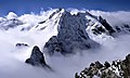 In mountainous areas one often finds the peaks above the clouds as seen here with the Piz Bernina in the Swiss Alps.
 -
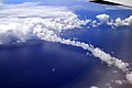 Clouds and cloud bow above the Pacific Ocean.
 -
Rain clouds over the North Sea taken from the coast of Herne Bay, Kent.
-
 Lenticular cloud over Wyoming.


See also
- Atmospheric Radiation Measurement (ARM) (in the US)
- Cloud albedo
- Cloud Appreciation Society
- Cloud condensation nuclei
- Cloud forcing
- Cloud seeding
- Cloudscape (art)
- Cloudscape photography
- Coalescence
- Extraterrestrial skies
- Flight ceiling
- Fractus cloud
- Cloud iridescence
- Mist
- Monsoon
- Mushroom cloud
- Orographic lift
- Precipitation
- Thunderstorm
- Tropical cyclone
- Weather lore
References
This article includes a list of general references, but it lacks sufficient corresponding inline citations. (September 2008) |
- ^ a b Cloud Classifications
- ^ "Plymouth State Meteorology Program Cloud Boutique".
- ^ "Cloud Types: common cloud classifications". WW2010. University of Illinois.
- ^ "cloud: Classification of Clouds". Infoplease.com.
- ^ Rainmaking Bacteria Ride Clouds to "Colonize" Earth?
Bibliography
- Hamblyn, Richard The Invention of Clouds – How an Amateur Meteorologist Forged the Language of the Skies Picador; Reprint edition (August 3, 2002). ISBN 0312420013
- http://www.ldeo.columbia.edu/news/2006/04_14_06.htm Could Reducing Global Dimming Mean a Hotter, Dryer World?
External links
 Definitions from Wiktionary
 Media from Commons
 News from Wikinews
 Quotations from Wikiquote
 Texts from Wikisource
 Textbooks from Wikibooks
 Resources from Wikiversity
- BadMeteorology's explanation of why clouds form
- Chitambo Clouds – Clouds and other meteorological phenomena Photographs and info. on different types of clouds.
- Monthly maps of global cloud cover, from NASA's Earth Observatory
- Cloud Appreciation Society Aesthetics of clouds
- A Planetary Order (Terrestrial Cloud Globe)
- Shuttle Views the Earth: Clouds from Space
- Details of main clould types and sub types
- USA Today Understanding clouds and Fog