
Göreme: Difference between revisions
| Line 92: | Line 92: | ||
[[ru:Национальный парк Гёреме]] |
[[ru:Национальный парк Гёреме]] |
||
[[sv:Göreme]] |
[[sv:Göreme]] |
||
[[th:เกอเรเม]] |
|||
[[tr:Göreme Tarihî Millî Parkı]] |
[[tr:Göreme Tarihî Millî Parkı]] |
||
[[zh:格雷梅]] |
[[zh:格雷梅]] |
||
Revision as of 03:53, 16 September 2012
You can help expand this article with text translated from the corresponding article in Turkish. (July 2009) Click [show] for important translation instructions.
|
| UNESCO World Heritage Site | |
|---|---|
 Göreme Valley | |
| Criteria | Volcanic Rock: i, iii, v, vii |
| Reference | 357 |
| Inscription | 1985 (9th Session) |
Göreme (pronounced [ˈɟøɾeme]; Ancient Greek: Κόραμα, Kòrama), located among the "fairy chimney" rock formations, is a town in Cappadocia, a historical region of Turkey. It is in the Nevşehir Province in Central Anatolia and has a population of around 2,500 people.
Former names of the town have been Korama, Matiana, Maccan or Machan, and Avcilar. When Göreme Valley nearby was designated an important tourist destination, a "center" for all tourism in Cappadocia, the name of the town was changed to Göreme for practical reasons.
The Göreme National Park (Göreme Milli Parklar in Turkish) was added to the UNESCO World Heritage List in 1985.
The location of Göreme was first settled back in the Roman period. Christianity was then the prevailing religion in the region, which is evident from many rock churches that can still be seen today.
Among Göreme's historically important sites are Ortahane, Durmus Kadir, Yusuf Koc and Bezirhane churches, in addition to the richly decorated Tokali Kilise, the Apple Church, and a number of homes and pigeon houses carved straight into the rock formations in the town.

Gallery
-
 Fairy Chimney Rock Formations.
 -
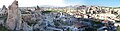 View of Göreme
 -
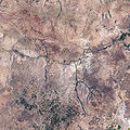 Goreme national park as seen from space.


See also
References
External links
- Template:Wikitravel
- Photos of Goreme
- Durmus Kadir church
- Troglodyte architecture in Göreme.
- A photo tour of walking tours from Göreme
| Aegean | |
|---|---|
| Black Sea | |
| Central Anatolia | |
| East Anatolia | |
| Marmara | |
| Mediterranean | |
| Southeastern Anatolia | |
| Multiple regions | |
38°40′N 34°50′E / 38.667°N 34.833°E
This geographical article about a location in Nevşehir Province, Turkey is a stub. You can help Wikipedia by expanding it. |