
Hormuz Island: Difference between revisions
m →External links: copyedit, already indirectly in category, refine cat, and AWB general fixes using AWB |
|||
| Line 140: | Line 140: | ||
==C'mon!== |
|||
Bring it on Wikigods! |
|||
==Gallery== |
==Gallery== |
||
<gallery widths="180px" heights="120px" perrow="3"> |
<gallery widths="180px" heights="120px" perrow="3"> |
||
Revision as of 17:13, 4 September 2015
This article needs additional citations for verification. (December 2009) |
Hormuz Island
جزیره هرمز | |
|---|---|
Island | |
 Khezr Beach, Hormuz Island, Persian Gulf, Iran, 02-09-2008. | |
| Country | Iran |
| Province | Hormozgān |
| Area | |
| • Land | 42 km2 (16.2 sq mi) |
| Elevation | 186 m (610 ft) |
| Time zone | UTC+3:30 (IRST) |

Hormuz Island (/hɔːrˈmuːz/; Persian: جزیره هرمز Jazireh-ye Hormoz), also spelled Hormoz, is an Iranian island in the Persian Gulf. Located in the Strait of Hormuz, 5 miles off the Iranian coast, the island is part of Hormozgān Province.
Geography
Hormuz Island has an area of 42 km2 (16 sq mi). It is covered by sedimentary rock and layers of volcanic material on its surface. The highest point of the island is about 186 metres above sea level. Due to a lack of precipitation, the soil and water are salty. Specialists have helped cultivar white mangrove or Hara trees to grow in the climate. Due to the lack of fresh water, Iranian engineers have constructed a water pipeline from the mainland.
History
The island, known as Organa (Όργανα) to the ancient Greeks and as Jarun in the Islamic period, acquired the name of "Hormuz" from the important harbour town of Hormuz (Ormus) on the mainland 60 km away, which had been a center of a minor principality on both sides of the strait. The principality paid tributes to the Mongol-ruled Ilkhanate and was an important source of income from maritime trade.[1] The town's ruler decided to shift his residence to the island during one of dynastic wars around 1300,[citation needed] in order to evade attacks by Mongolian and Turkish groups from the interior. The ruler later made peace with the Ilkhans.
A new town was built on the northern tip of Jarun island which was called New Hormuz for a number of years to distinguish it from the old town on the mainland until this fell into ruins. Slowly the name of the new town came to be used for the island as well.
The extremely arid and during the summer months very hot island was not an ideal location for the capital of a principality as all provisions including water had to be brought from the mainland. Its location, however, gave it a degree of security which let it grow to be a major trading port for several centuries especially as its competitors suffered repeatedly from destruction through acts of war and plunder.
In the 15th century, Hormuz was visited several times by a Chinese fleet led by Zheng He.
The Portuguese conqueror, Afonso de Albuquerque, captured the island in 1507 and it became a part of the Portuguese Empire. The Portuguese constructed a fortress on the island, the Fort of Our Lady of the Conception. In 1622 the island was captured from the Portuguese by a combined Anglo-Persian force.
Shah Abbas I distrusted the local population and was not interested in maintaining the island as a trading center or military post; instead he developed the nearby mainland port of Bander Abbas. Hormuz went into decline. Many of its inhabitants seasonally moved to their fields and orchards around the old Hormuz on the mainland, only fishermen being in permanent residence. The island continued to export small quantities of rock salt and lumps of iron oxide which were used as ballast stones for sailing ships.[2]
After a period of Omani administration in the 19th century, it remained just as a sparsely inhabited fishermen' island and showed some development in the later years of the 20th century.

The Museum and Gallery of Dr. Ahmad Nadalian in Hormuz Island
The Museum and Gallery of Dr. Ahmad Nadalian in Hormuz Island shows the works of this artists who is internationally known as one of the most active environmental artists. Now most of Nadalian works are scattered across the earth. His environmental art projects, include the carving of rocks that can be found in many countries. Before the establishing art center the people who addicted to alcohol and drug used this space. In March 2009, the Paradise Art Centre on Hormuz Island in the Persian Gulf was established here.
C'mon!
Bring it on Wikigods!
Gallery
-
 Hormuz Island beach
 -
 Hormoz Island
 -
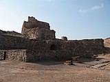 The Fort of Our Lady of the Conception, Hormuz Island, Iran
 -
 Hara forests at Hormuz Island


.jpg)

See also
Notes
- ^ Cambridge history of India, vol. 1, p.147
- ^ Hormuz in the Encyclopedia Iranica
References
- . الكوخردى ، محمد ، بن يوسف، (كُوخِرد حَاضِرَة اِسلامِيةَ عَلي ضِفافِ نَهر مِهران) الطبعة الثالثة ،دبى: سنة 199۷ للميلاد Mohammed Kookherdi (1997) Kookherd, an Islamic civil at Mehran river, third edition: Dubai
- . کامله،القاسمی، بنت شیخ عبدالله، (تاریخ لنجة) مکتبة دبي للتوزیع، الامارات: الطبعة الثانية عام ۱۹۹۳ للمیلاد
- . الوحیدی الخنجی، حسین بن علی بن احمد، «تاریخ لنجه» ، الطبعة الثانية دبی: دار الأمة للنشر والتوزیع، ۱۹۸۸ للمیلاد
- . اطلس گیتاشناسی استانهای ایران [Atlas Gitashenasi Ostanhai Iran] (Gitashenasi Province Atlas of Iran)
External links
Hormozgan Province, Iran | |||||||||||||||||||||||||
|---|---|---|---|---|---|---|---|---|---|---|---|---|---|---|---|---|---|---|---|---|---|---|---|---|---|
| Capital |  | ||||||||||||||||||||||||
| Counties and cities |
| ||||||||||||||||||||||||
| Sights |
| ||||||||||||||||||||||||
| populated places | |||||||||||||||||||||||||
| See also | |||||||||||||||||||||||||