
Agasthyamalai Hills: Difference between revisions
that's a wikipedia mirror |
Cyberbot II (talk | contribs) Rescuing 2 sources, flagging 0 as dead, and archiving 9 sources. #IABot |
||
| Line 31: | Line 31: | ||
These hills are dominated by the {{convert|1868|m|ft|0}} [[Agasthyamalai]] peak. The five-peaked mountain [http://wikimapia.org/#lat=8.5990981&lon=77.2668457&z=16&l=0&m=b&v=6&search=Ainthuthalai Ainthuthalai Pothigai] ({{convert|1862|m|ft|0}}) immediately adjacent to Agasthyamalai, is only a little shorter. Other nearby peaks are [[Cherumunji Mottai]] and [http://wikimapia.org/#lat=8.5939&lon=77.2861147&z=16&l=0&m=s&v=9 Naga Pothigai] ({{coord|8|35|38|N|77|17|10|E}}) ({{convert|1600|m|ft}}). There are at least 23 more peaks over {{convert|1600|m|ft}}.<ref name="peak">{{cite web|url=http://wikimapia.org/#lat=8.6027473&lon=77.2558594&z=12&l=0&m=s&v=9&search=Peak|title=Search: Peak|publisher=Wikimapia|accessdate=12 December 2009| archiveurl= http://web.archive.org/web/20091208173649/http://www.wikimapia.org/#y=46341200&x=-94282400&zo=6&l=0&m=a&spnx=0.11&spny=0.18| archivedate= 8 December 2009 | deadurl= no}}</ref> |
These hills are dominated by the {{convert|1868|m|ft|0}} [[Agasthyamalai]] peak. The five-peaked mountain [http://wikimapia.org/#lat=8.5990981&lon=77.2668457&z=16&l=0&m=b&v=6&search=Ainthuthalai Ainthuthalai Pothigai] ({{convert|1862|m|ft|0}}) immediately adjacent to Agasthyamalai, is only a little shorter. Other nearby peaks are [[Cherumunji Mottai]] and [http://wikimapia.org/#lat=8.5939&lon=77.2861147&z=16&l=0&m=s&v=9 Naga Pothigai] ({{coord|8|35|38|N|77|17|10|E}}) ({{convert|1600|m|ft}}). There are at least 23 more peaks over {{convert|1600|m|ft}}.<ref name="peak">{{cite web|url=http://wikimapia.org/#lat=8.6027473&lon=77.2558594&z=12&l=0&m=s&v=9&search=Peak|title=Search: Peak|publisher=Wikimapia|accessdate=12 December 2009| archiveurl= http://web.archive.org/web/20091208173649/http://www.wikimapia.org/#y=46341200&x=-94282400&zo=6&l=0&m=a&spnx=0.11&spny=0.18| archivedate= 8 December 2009 | deadurl= no}}</ref> |
||
The hills receive up to {{convert|5000|mm|in}} annual rainfall<ref name="Giriraj">{{cite journal|author1=A. Giriraj|author2=M. S. R. Murthy|author3=C. Beierkuhnlein |
The hills receive up to {{convert|5000|mm|in}} annual rainfall<ref name="Giriraj">{{cite journal|author1=A. Giriraj |author2=M. S. R. Murthy |author3=C. Beierkuhnlein |date=1-30- 2009 |title=Evaluating forest fragmentation and its tree community composition in the tropical rain forest of Southern Western Ghats (India) from 1973 to 2004 |journal=Ecological Research |publisher=© Springer Science + Business Media B.V. |issue=DOI 10.1007/s10661-008-0724-5 |page=2 |url=https://www.bitoek.uni-bayreuth.de/bayceer/en/pub/pub/67626/Giriaj2009_Evaluating_forest_fragmentation.pdf |deadurl=yes |archiveurl=https://web.archive.org/20110719101845/https://www.bitoek.uni-bayreuth.de/bayceer/en/pub/pub/67626/Giriaj2009_Evaluating_forest_fragmentation.pdf |archivedate=July 19, 2011 }}</ref> from both the southwest and northeast [[monsoon]]s and has a very short dry season of January to March. The topography is rugged with many perennial hill streams originating in the tropical rainforests on the upper slopes. These streams merge to form several important rivers. The Kerala rivers [[Kallada River|Kallada]], [[Achankoil River|Achankoil]], [[Vamanapuram River|Vamanapuram]], [[Karamana River|Karamana]] and [[Neyyar River|Neyyar]] drain west from these hills. The [[Thamirabarani River]] and its tributaries the [[Thamirabarani River#Tributaries|Ramanadhi River]] and the [[Manimuthar River]] in Tamil Nadu are significant perennial rivers flowing east from these hills.<ref name="Lockwood">{{cite news |
||
|url=http://www.hinduonnet.com/fline/fl2209/stories/20050506000106500.htm |
|url=http://www.hinduonnet.com/fline/fl2209/stories/20050506000106500.htm |
||
|title=Heritage Hills|last=Lockwood|first=Ian|date=2005-04-23 |
|title=Heritage Hills|last=Lockwood|first=Ian|date=2005-04-23 |
||
| Line 45: | Line 45: | ||
These hills are noted as the habitat for at least 2,000 species of [[Herbalism|medicinal plants]], of which at least 50 are rare and [[endangered species]].<ref>Ministry of Forests and Environment-Report Ch10 [http://envfor.nic.in/divisions/ic/wssd/doc2/ch10.html Biodiversity/Kanis]</ref><ref>The Hindu, Jan 3, 2006.[http://www.hindu.com/2006/01/03/stories/2006010301290400.htm Environment Ministry to soon declare Agastyamalai a biosphere reserve]</ref> There are also wild relatives of [[jackfruit]], [[mango]], [[cardamom]], [[turmeric]] and [[banana]].<ref name="Lockwood"/> |
These hills are noted as the habitat for at least 2,000 species of [[Herbalism|medicinal plants]], of which at least 50 are rare and [[endangered species]].<ref>Ministry of Forests and Environment-Report Ch10 [http://envfor.nic.in/divisions/ic/wssd/doc2/ch10.html Biodiversity/Kanis]</ref><ref>The Hindu, Jan 3, 2006.[http://www.hindu.com/2006/01/03/stories/2006010301290400.htm Environment Ministry to soon declare Agastyamalai a biosphere reserve]</ref> There are also wild relatives of [[jackfruit]], [[mango]], [[cardamom]], [[turmeric]] and [[banana]].<ref name="Lockwood"/> |
||
[[Endangered]] [[mammals]] here include the [[Bengal tiger]], [[Indian elephant]], [[lion-tailed macaque]]s, [[Nilgiri tahr]] and the [[Vulnerable species|vulnerable]] [[gaur]], [[sloth bear]], [[Malabar spiny dormouse]] and [[Nilgiri marten]]. There are also [[Jerdon's palm civet]], [[gray slender loris]], [[great pied hornbill]]s and [[king cobra]]s.<ref name="atree">{{cite web|url=http://www.atree.org/kmtr.html|title=Overview of research in KMTR |year=2005|publisher=[[ATREE]]|accessdate=14 December 2009 |
[[Endangered]] [[mammals]] here include the [[Bengal tiger]], [[Indian elephant]], [[lion-tailed macaque]]s, [[Nilgiri tahr]] and the [[Vulnerable species|vulnerable]] [[gaur]], [[sloth bear]], [[Malabar spiny dormouse]] and [[Nilgiri marten]]. There are also [[Jerdon's palm civet]], [[gray slender loris]], [[great pied hornbill]]s and [[king cobra]]s.<ref name="atree">{{cite web|url=http://www.atree.org/kmtr.html |title=Overview of research in KMTR |year=2005 |publisher=[[ATREE]] |accessdate=14 December 2009 |deadurl=yes |archiveurl=https://web.archive.org/20080513140719/http://www.atree.org/kmtr.html |archivedate=May 13, 2008 }}</ref> [[Ecotourism]] is popular in the area.<ref name="Thenmala">{{cite web|url=http://www.keralatourism.org/destination/others/thenmala--eco-tourism-91.php|title=Thenmala, Eco-Tourism|year=1998|publisher=Department of Tourism, Government of Kerala|accessdate=12 December 2009|location=Thiruvananthapuram| archiveurl= http://web.archive.org/web/20091205191722/http://www.keralatourism.org/destination/others/thenmala--eco-tourism-91.php| archivedate= 5 December 2009 | deadurl= no}}</ref> |
||
==Protected areas== |
==Protected areas== |
||
Revision as of 23:06, 29 January 2016
| Agasthyamalai Hills (Ashambu Hills) | |
|---|---|
 Agasthyamalai, the highest of 26 peaks in these hills over 1,600 metres (5,200 ft) | |
| Highest point | |
| Elevation | 1,868 m (6,129 ft) |
| Prominence | 1,668 m (5,472 ft) |
| Coordinates | 8°39′N 77°13′E / 8.650°N 77.217°E |
| Naming | |
| English translation | Mountains of the medicine maker |
| Language of name | Tamil |
| Geography | |
| Location | Kerala & Tamil Nadu, South India |
| Parent range | Western Ghats |
| Topo map | |
| Geology | |
| Age of rock | Cenozoic, 100 to 80 mya |
| Mountain type | Fault Description |
| Climbing | |
| Easiest route | trekking via Peppara Wildlife Sanctuary |

The Agasthyamalai Hills also called the Ashambu Hills, lie at the extreme southern end of the Western Ghats mountain range along the western side of South India. There are at least 26 peaks over 1,600 metres (5,200 ft) among these hills. The hills are notable as the habitat for over 2,000 species of medicinal plants and as the abode of the Vedic sage Agasthya, founder of the Siddhar practitioners of Rasayana herbal medicine, who is often depicted holding a mortar and pestle.[1]
These hills contain areas of exceptional natural beauty and aesthetic importance. The hills contain outstanding examples of ecosystems and communities of plants and animals representing significant ecological and biological processes. The area contains important and significant natural habitats for in-situ conservation of biological diversity, including forests containing threatened species of outstanding value to science and conservation.[2]
Geography
The hills straddle both sides of the state border Kollam District and Thiruvananthapuram District in Kerala and Tirunelveli District and Kanyakumari District in Tamil Nadu. They are between the Cardamom Hills and Aryankavu Pass at NH-208 about 9° north latitude and the vicinity of the Mahendragiri peak near Kanyakumari at about 8° 20' north latitude.[2] The border between the two States is defined by a jagged high ridge, that runs from north to south and then slightly eastwards, parallel to and about 40 kilometres (25 mi)* east of the Kerala shore of the Arabian Sea.
These hills are dominated by the 1,868 metres (6,129 ft) Agasthyamalai peak. The five-peaked mountain Ainthuthalai Pothigai (1,862 metres (6,109 ft)) immediately adjacent to Agasthyamalai, is only a little shorter. Other nearby peaks are Cherumunji Mottai and Naga Pothigai (8°35′38″N 77°17′10″E / 8.59389°N 77.28611°E) (1,600 metres (5,200 ft)). There are at least 23 more peaks over 1,600 metres (5,200 ft).[3]
The hills receive up to 5,000 millimetres (200 in) annual rainfall[4] from both the southwest and northeast monsoons and has a very short dry season of January to March. The topography is rugged with many perennial hill streams originating in the tropical rainforests on the upper slopes. These streams merge to form several important rivers. The Kerala rivers Kallada, Achankoil, Vamanapuram, Karamana and Neyyar drain west from these hills. The Thamirabarani River and its tributaries the Ramanadhi River and the Manimuthar River in Tamil Nadu are significant perennial rivers flowing east from these hills.[1][2]
Environment

Agastyamalai is home to the Kanikkaran people, one of the oldest surviving hunter-gatherer tribes in the world.[5]
The Ashambu Hills include the Indian Ecoregions of South Western Ghats moist deciduous forests above 500 metres (1,600 ft), South Western Ghats montane rain forests above 1,000 metres (3,300 ft) and shola-grasslands complex on peaks above 1,600 metres (5,200 ft).[6]
These hills are noted as the habitat for at least 2,000 species of medicinal plants, of which at least 50 are rare and endangered species.[7][8] There are also wild relatives of jackfruit, mango, cardamom, turmeric and banana.[1]
Endangered mammals here include the Bengal tiger, Indian elephant, lion-tailed macaques, Nilgiri tahr and the vulnerable gaur, sloth bear, Malabar spiny dormouse and Nilgiri marten. There are also Jerdon's palm civet, gray slender loris, great pied hornbills and king cobras.[9] Ecotourism is popular in the area.[10]
Protected areas
The eastern side of the hills in Tamil Nadu includes the Kalakkad Mundanthurai Tiger Reserve (KMTR), a 895 square kilometres (346 sq mi) protected area. The Kerala side of the hills hosts the 128 square kilometres (49 sq mi) Neyyar Wildlife Sanctuary, the 53 square kilometres (20 sq mi) Peppara Wildlife Sanctuary, the 171 square kilometres (66 sq mi) Shenduruny Wildlife Sanctuary and the Kulathupuzha and Palode Reserve forests near Courtallam. The Naraikadu forest or “grey jungle”, surrounded by the Kalakad Mundanthurai Tiger Reserve, is privately owned by the Dhonavur Fellowship. This community has restored and protected the area so well that it is one of the best preserved forest tracts in the whole Ashambu Hills.[11]
These protected areas in the Agasthyamala Hills comprise the Agasthyamalai Biosphere Reserve (ABR). This reserve includes 3,500.36 km2 (1,351.50 sq mi) out of which 1,828 square kilometres (706 sq mi) is in Kerala and 1,672.36 square kilometres (645.70 sq mi) is in Tamil Nadu.[12][13]
The Western Ghats, Agasthyamalai Sub-Cluster, including all of Agasthyamalai Biosphere Reserve, is under consideration by the UNESCO World Heritage Committee for selection as a World Heritage Site.[2]
Tourism

There are several Hindu Temples and seasonal waterfalls which are important tourist attractions in these hills. At Suruli Falls there is a 2-stage Cascading water fall The Suruli River supplying the falls originates from the Meghamalai Hills. The falls drop from a height of 150 feet (46 m) collect into a pool, flow for a short distance and again plummet an additional 40 feet (12 m). Near the falls are 18 caves some of which represent Indian rock-cut architecture temples of the 18th Century. This popular destination for tourists and devout pilgrims is easily reached by road 56 km (35 mi) from Theni and 10 km (6.2 mi) from Cumbum in the Theni District.
Many pilgrims climb Agasthyamalai in the core of the hills to perform a puja ceremony at the Agasthya Murti on the top the Peak. Most pilgrims use the well-worn path through Peppara Wildlife Sanctuary on the Kerala side. The trekkers start from Bonaccord estate in Thiruvananthapuram district with a guide from the Forest Department. The first night is spent at a camp facility set up by the Department in the middle of the forests. Trekkers reach the peak the next day and return to the camp the same day. Only 100 pilgrims per day are allowed on this route during the January February season.[1][14]
Visitors must obtain an entry pass from the Trivandrum Forest Headquarters against payment of Rs 500.From 2014 onwards booking can be done through Kerala Forest website. Apply to: Chief Conservator of Forests (Wildlife), Forest Headquarters, Trivandrum 695 014. Phone : 0471 322217. The Chief Conservator (Agasthyavanam) Phone: 325385 is responsible for on site management of the protected areas on the Kerala side of the Hills.[12]
Gallery
- Views of the Agasthyamalai Hills
-
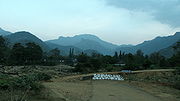
 Hills at Ponmudi
 -
 Ponmudi Peak
 -
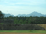
 Hills from Nagercoil
 -
 Hills from Keeriparai Reserve Forest
 -
 Hills from Vattakottai Fort
 -
 top of Tirparappu Waterfalls
 -
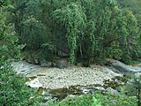 Stream in Keeriparai Reserve Forest
 -
 Vattaparai Falls in dry season
 -


References
- ^ a b c d Lockwood, Ian (2005-04-23). "Heritage Hills". Frontline - Nature. Chennai: The Hindu. pp. Volume 22 - Issue 09. Retrieved 10 December 2009. Cite error: The named reference "Lockwood" was defined multiple times with different content (see the help page).
- ^ a b c d "Description Western Ghats—Agasthyamalai Sub-Cluster (with Five Site Elements)". Tentative Lists- India. UNESCO World Heritage Centre. 2006-03-15. pp. Western Ghats (sub cluster nomination). Retrieved 11 December 2009.
- ^ "Search: Peak". Wikimapia. Archived from the original on 8 December 2009. Retrieved 12 December 2009.
{{cite web}}: Unknown parameter|deadurl=ignored (|url-status=suggested) (help) - ^ A. Giriraj; M. S. R. Murthy; C. Beierkuhnlein (1-30- 2009). "Evaluating forest fragmentation and its tree community composition in the tropical rain forest of Southern Western Ghats (India) from 1973 to 2004" (PDF). Ecological Research (DOI 10.1007/s10661-008-0724-5). © Springer Science + Business Media B.V.: 2. Archived from the original (PDF) on July 19, 2011.
{{cite journal}}: Check date values in:|date=(help); Unknown parameter|deadurl=ignored (|url-status=suggested) (help) - ^ Anuradha, R.V., Sharing With The Kanis, A case study from Kerala, India
- ^ "South Western Ghats montane rain forests". Terrestrial Ecoregions. World Wildlife Fund. Retrieved 14 December 2009.
- ^ Ministry of Forests and Environment-Report Ch10 Biodiversity/Kanis
- ^ The Hindu, Jan 3, 2006.Environment Ministry to soon declare Agastyamalai a biosphere reserve
- ^ "Overview of research in KMTR". ATREE. 2005. Archived from the original on May 13, 2008. Retrieved 14 December 2009.
{{cite web}}: Unknown parameter|deadurl=ignored (|url-status=suggested) (help) - ^ "Thenmala, Eco-Tourism". Thiruvananthapuram: Department of Tourism, Government of Kerala. 1998. Archived from the original on 5 December 2009. Retrieved 12 December 2009.
{{cite web}}: Unknown parameter|deadurl=ignored (|url-status=suggested) (help) - ^ Lockwood, Ian (2009). "Naraikadu Forest Canopy, Kalakad Mundanthurai Tiger Reserve, Tamil Nadu". High Range Photography. Retrieved 14 December 2009.
- ^ a b Kerala Forests & Wildlife Dept, Biosphere Reserves.Agasthyamala Biosphere Reserve
- ^ Tamil Nadu Forest Department (2007) retrieved 9/2/2007 AGASTHIYARMALAI BIOSPHERE RESERVE
- ^ "Pilgrimage to Agastyakoodam begins". Kurinji.in. 2009. Retrieved 12 December 2009.