
Harlem–148th Street station: Difference between revisions
Epicgenius (talk | contribs) →History: add box |
Rescuing 2 sources and tagging 0 as dead. #IABot (v1.2.7.1) |
||
| Line 99: | Line 99: | ||
The station's only [[mezzanine (architecture)|mezzanine]] is at the west ([[railroad directions|railroad north]]) end of the station. From the single [[island platform]], a double-wide stairway leads up to a set of doors that separate the street-level station-house at Adam Clayton Powell Jr. Boulevard. There are three [[turnstile]]s and a token-booth. |
The station's only [[mezzanine (architecture)|mezzanine]] is at the west ([[railroad directions|railroad north]]) end of the station. From the single [[island platform]], a double-wide stairway leads up to a set of doors that separate the street-level station-house at Adam Clayton Powell Jr. Boulevard. There are three [[turnstile]]s and a token-booth. |
||
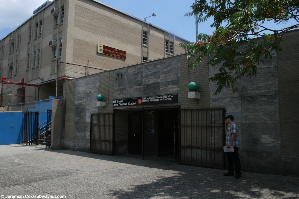
While this station may appear to be underground, it and the adjacent yard are actually at-grade. The Esplanade Gardens apartment complex exists between 147th and 149th streets while [[Frederick Douglass Academy]] High School sits between 149th and 150th Streets;<ref name=NYCDCP-ManhattanOpenCut>{{cite web|title=INVENTORY OF DECKING OPPORTUNITIES OVER TRANSPORTATION PROPERTIES Final Report: 6.3: TRANSIT AND RAILROAD OPEN CUTS: MANHATTAN|url=http://www.nyc.gov/html/dcp/pdf/transportation/deck05.pdf|website=[[Government of New York City|nyc.gov]]|publisher=[[New York City Department of City Planning]]|date=September 2008|accessdate=6 August 2015}}</ref><ref name=NYCDCP-BklynRailYards>{{cite web|title=INVENTORY OF DECKING OPPORTUNITIES OVER TRANSPORTATION PROPERTIES Final Report: 6.7: TRANSIT AND RAILROAD YARDS: BROOKLYN|url=http://www.nyc.gov/html/dcp/pdf/transportation/deck09.pdf|website=[[Government of New York City|nyc.gov]]|publisher=[[New York City Department of City Planning]]|date=September 2008|accessdate=6 August 2015}}</ref><ref name=MTA-NorthHarlemMap-2015>{{cite web|title=MTA Neighborhood Maps: Harlem / Hamilton Heights|url=http://web.mta.info/maps/neighborhoods/mn/M19_harlem_ham_hts_2015.pdf|website=[[Metropolitan Transportation Authority|mta.info]]|publisher=[[Metropolitan Transportation Authority]]|accessdate=12 July 2015|date=2015}}</ref> both structures rest on [[pilotis]] above the station and yard.<ref name=NYCDCP-BklynRailYards /><ref>[http://www.subwaynut.com/irt/148n3/148n34.jpg Powell Boulevard Station entrance (The Subway Nut)]</ref><ref>[https://maps.google.com/?ll=40.824088,-73.937194&spn=0.012194,0.022724&t=m&z=16&layer=c&cbll=40.823964,-73.937276&panoid=MDg0VGnT9DeaYgA2y96vyw&cbp=12,83.84,,1,-1.36 West end of the station (under the parking lot to the left) from Google Maps Street View]</ref><ref>[https://maps.google.com/?ll=40.823049,-73.934491&spn=0.012195,0.022724&t=m&layer=c&cbll=40.822818,-73.934471&panoid=uYDMlK4cBPJKXaEMLWhpoA&cbp=12,323.24,,1,8.97&z=16 East end of the station from Google Maps Street View]</ref> Unlike other at-grade stations, however, 148th Street is not [[ADA-accessible]] because there is a staircase down to platform level. |
While this station may appear to be underground, it and the adjacent yard are actually at-grade. The Esplanade Gardens apartment complex exists between 147th and 149th streets while [[Frederick Douglass Academy]] High School sits between 149th and 150th Streets;<ref name=NYCDCP-ManhattanOpenCut>{{cite web|title=INVENTORY OF DECKING OPPORTUNITIES OVER TRANSPORTATION PROPERTIES Final Report: 6.3: TRANSIT AND RAILROAD OPEN CUTS: MANHATTAN |url=http://www.nyc.gov/html/dcp/pdf/transportation/deck05.pdf |website=[[Government of New York City|nyc.gov]] |publisher=[[New York City Department of City Planning]] |date=September 2008 |accessdate=6 August 2015 |deadurl=yes |archiveurl=https://web.archive.org/web/20160304194412/http://www.nyc.gov/html/dcp/pdf/transportation/deck05.pdf |archivedate=4 March 2016 |df= }}</ref><ref name=NYCDCP-BklynRailYards>{{cite web|title=INVENTORY OF DECKING OPPORTUNITIES OVER TRANSPORTATION PROPERTIES Final Report: 6.7: TRANSIT AND RAILROAD YARDS: BROOKLYN |url=http://www.nyc.gov/html/dcp/pdf/transportation/deck09.pdf |website=[[Government of New York City|nyc.gov]] |publisher=[[New York City Department of City Planning]] |date=September 2008 |accessdate=6 August 2015 |deadurl=yes |archiveurl=https://web.archive.org/web/20100606135647/http://www.nyc.gov/html/dcp/pdf/transportation/deck09.pdf |archivedate=6 June 2010 |df= }}</ref><ref name=MTA-NorthHarlemMap-2015>{{cite web|title=MTA Neighborhood Maps: Harlem / Hamilton Heights|url=http://web.mta.info/maps/neighborhoods/mn/M19_harlem_ham_hts_2015.pdf|website=[[Metropolitan Transportation Authority|mta.info]]|publisher=[[Metropolitan Transportation Authority]]|accessdate=12 July 2015|date=2015}}</ref> both structures rest on [[pilotis]] above the station and yard.<ref name=NYCDCP-BklynRailYards /><ref>[http://www.subwaynut.com/irt/148n3/148n34.jpg Powell Boulevard Station entrance (The Subway Nut)]</ref><ref>[https://maps.google.com/?ll=40.824088,-73.937194&spn=0.012194,0.022724&t=m&z=16&layer=c&cbll=40.823964,-73.937276&panoid=MDg0VGnT9DeaYgA2y96vyw&cbp=12,83.84,,1,-1.36 West end of the station (under the parking lot to the left) from Google Maps Street View]</ref><ref>[https://maps.google.com/?ll=40.823049,-73.934491&spn=0.012195,0.022724&t=m&layer=c&cbll=40.822818,-73.934471&panoid=uYDMlK4cBPJKXaEMLWhpoA&cbp=12,323.24,,1,8.97&z=16 East end of the station from Google Maps Street View]</ref> Unlike other at-grade stations, however, 148th Street is not [[ADA-accessible]] because there is a staircase down to platform level. |
||
== References == |
== References == |
||
Revision as of 08:57, 30 November 2016
Harlem–148th Street | |||||||
|---|---|---|---|---|---|---|---|
 View of platform at Harlem–148th Street | |||||||
| Station statistics | |||||||
| Address | West 149th Street & Adam Clayton Powell Jr. Boulevard New York, NY 10039 | ||||||
| Borough | Manhattan | ||||||
| Locale | Harlem | ||||||
| Division | A (IRT)[1] | ||||||
| Line | IRT Lenox Avenue Line | ||||||
| Services | 3 | ||||||
| Transit | |||||||
| Structure | At-grade | ||||||
| Platforms | 1 island platform | ||||||
| Tracks | 2 | ||||||
| Other information | |||||||
| Opened | May 13, 1968 | ||||||
| Opposite- direction transfer | N/A | ||||||
| Former/other names | 148th Street–Lenox Terminal | ||||||
| Traffic | |||||||
| 2023 | 679,539[2] | ||||||
| Rank | 353 out of 423[2] | ||||||
| Station succession | |||||||
| Next north | Template:NYCS next | ||||||
| Next south | Template:NYCS next | ||||||
| |||||||
Harlem–148th Street (signed as 148th Street–Lenox Terminal) is a terminal station on the IRT Lenox Avenue Line of the New York City Subway. The station is located in Harlem, though the name is partially erroneous, as the station is actually at the intersection of 149th Street and Adam Clayton Powell Jr. Boulevard.[4] It is served by the 3 train at all times.
History
| style="color:white;background:#Template:NYCS color;text-align:center;padding:5px"| Track layout | |||||||||||||||||||||||||||||||||||||||||||||||||||||||||||||||||||||||||||||
|---|---|---|---|---|---|---|---|---|---|---|---|---|---|---|---|---|---|---|---|---|---|---|---|---|---|---|---|---|---|---|---|---|---|---|---|---|---|---|---|---|---|---|---|---|---|---|---|---|---|---|---|---|---|---|---|---|---|---|---|---|---|---|---|---|---|---|---|---|---|---|---|---|---|---|---|---|---|
| |||||||||||||||||||||||||||||||||||||||||||||||||||||||||||||||||||||||||||||

The location and tracks of the station were originally part of the Lenox Avenue Yard opened in 1904, where 3 trains are currently assigned and stored.[5][6] An extension of the Lenox Avenue line to 149th or 150th Street had been proposed since the Dual Contracts of the 1910s. In 1916, an extension to 149th Street was proposed as part of a connection between the Lenox Avenue Line and the IRT Jerome Avenue Line in the Bronx (served by the 4 train).[7]
In 1957, a station at 150th Street within the Lenox Yard was proposed to better serve the local area (including the nearby Harlem River Houses).[8] The station, and the Bronx extension, had been requested by local citizens since the 1940s due to unreliable bus and surface trolley service.[9] The station was later moved to 149th Street due to the downsizing of the Lenox Yard in the 1960s, with the land sold to the developers that would build the high school and apartment complex above the yard and station (see below).[10][11]
The new terminal, when completed, was intended to be a replacement for the former terminal at 145th Street station due to the proximity of switches that prevented the station's lengthening to accommodate ten-car trains. However, plans to shut down 145th Street were cancelled due to protests from local residents.[12][13] 148th Street Station opened on May 13, 1968.[14] The name of the station was to be 149th Street–Seventh Avenue, but because of possible confusion with 149th Street–Grand Concourse, it was changed to 148th Street–Lenox Terminal.[10]
The station sign was reversed as Lenox Terminal–148th Street in the 1990s before reverting back to its original name by 2003.[15]
From 1995 to 2008, this station lacked full-time service, as 3 trains did not operate during late nights. Full-time service was restored on July 27, 2008.[16]
Station layout
| G | Street Level | Exit/Entrance |
| Fare control | Station agent, MetroCard vending machines | |
| P Platform level | ||
| Yard tracks | No passenger service | |
| Track 2 | → | |
| Island platform, doors will open on the left or right | ||
| Track 1 | → | |
| Maintenance tracks | No passenger service | |
This station is the northern terminal of the IRT Lenox Avenue Line. There are two tracks and one island platform here. The tracks end at bumper blocks at the west end of the platform. Next to the station is Lenox Yard, which is used for train storage and has no maintenance facility. The yard predates the station, which was added in 1968 at a relatively low cost, since the yard and the track connection were already there.[14][8] Formerly, the terminal was one station to the south, at 145th Street. Due to the high ceiling, platform service information signs are hung from heavy cables.
The station's only mezzanine is at the west (railroad north) end of the station. From the single island platform, a double-wide stairway leads up to a set of doors that separate the street-level station-house at Adam Clayton Powell Jr. Boulevard. There are three turnstiles and a token-booth.
While this station may appear to be underground, it and the adjacent yard are actually at-grade. The Esplanade Gardens apartment complex exists between 147th and 149th streets while Frederick Douglass Academy High School sits between 149th and 150th Streets;[17][18][4] both structures rest on pilotis above the station and yard.[18][19][20][21] Unlike other at-grade stations, however, 148th Street is not ADA-accessible because there is a staircase down to platform level.
References
- ^ "Glossary". Second Avenue Subway Supplemental Draft Environmental Impact Statement (SDEIS) (PDF). Vol. 1. Metropolitan Transportation Authority. March 4, 2003. pp. 1–2. Archived from the original (PDF) on February 26, 2021. Retrieved January 1, 2021.
- ^ a b "Annual Subway Ridership (2018–2023)". Metropolitan Transportation Authority. 2023. Retrieved April 20, 2024.
- ^ "Facts and Figures: Annual Subway Ridership". Metropolitan Transportation Authority. Retrieved 2016-04-19.
- ^ a b "MTA Neighborhood Maps: Harlem / Hamilton Heights" (PDF). mta.info. Metropolitan Transportation Authority. 2015. Retrieved 12 July 2015.
- ^ "Task of Placing the Cars in New Subway: Transfer from the Elevated to the Underground Tracks". nytimes.com. The New York Times. November 15, 1903. Retrieved 10 July 2015.
- ^ "New Contracts Let for Interboro Yards: Rejection of Earlier Bids by the City Make $50,610 Temporary Facilities Necessary". nytimes.com. The New York Times. June 8, 1922. Retrieved 10 July 2015.
- ^ "Two Subway Agreements: Provide for Connecting Links and Station Improvements". nytimes.com. The New York Times. November 12, 1916. Retrieved 10 July 2015.
- ^ a b "Asks Extension Of IRT Subway". New York Amsterdam News. August 10, 1957. Archived from the original on 2015-07-10. Retrieved 10 July 2015.
{{cite web}}: Unknown parameter|deadurl=ignored (|url-status=suggested) (help) - ^ "Public Service Gripes Are Old". New York Amsterdam News. October 19, 1946. Archived from the original on 2015-07-10. Retrieved 10 July 2015.
{{cite web}}: Unknown parameter|deadurl=ignored (|url-status=suggested) (help) - ^ a b Raudenbush, Henry (January 2007). "148th Street-Lenox Terminal and How it Got its Name". New York Division Bulletin. 50 (1). Electric Railroaders Association. Retrieved 2016-06-20.
- ^ "IRT REPAIR YARD TO REVERT TO CITY: 19 Acres in Harlem Will Be Turned Back by Dec. 31 -- Realty Men Interested". nytimes.com. The New York Times. October 14, 1960. Retrieved 10 July 2015.
- ^ Edwards, Dick (December 2, 1967). "145th-Lenox Subway Stop To Continue". New York Amsterdam News. Retrieved 10 July 2015.[dead link]
- ^ Cox, Jeremiah (June 26, 2008). "148th Street–Lenox Terminal Pictures". The Subway Nut. Retrieved September 1, 2012.
- ^ a b "IRT Passengers Get New 148th St. Station". The New York Times. May 14, 1968. p. 95. Retrieved October 4, 2011.
- ^ Weinberg, Brian (24 June 2003). "Station sign, by 2003". www.nycsubway.org. www.nycsubway.org. Retrieved 23 August 2016.
- ^ "Service Enhancements on 3 Line" (Press release). MTA New York City Transit. 2008-07-24. Retrieved 2008-07-26.
- ^ "INVENTORY OF DECKING OPPORTUNITIES OVER TRANSPORTATION PROPERTIES Final Report: 6.3: TRANSIT AND RAILROAD OPEN CUTS: MANHATTAN" (PDF). nyc.gov. New York City Department of City Planning. September 2008. Archived from the original (PDF) on 4 March 2016. Retrieved 6 August 2015.
{{cite web}}: Unknown parameter|deadurl=ignored (|url-status=suggested) (help) - ^ a b "INVENTORY OF DECKING OPPORTUNITIES OVER TRANSPORTATION PROPERTIES Final Report: 6.7: TRANSIT AND RAILROAD YARDS: BROOKLYN" (PDF). nyc.gov. New York City Department of City Planning. September 2008. Archived from the original (PDF) on 6 June 2010. Retrieved 6 August 2015.
{{cite web}}: Unknown parameter|deadurl=ignored (|url-status=suggested) (help) - ^ Powell Boulevard Station entrance (The Subway Nut)
- ^ West end of the station (under the parking lot to the left) from Google Maps Street View
- ^ East end of the station from Google Maps Street View
External links
- nycsubway.org – IRT White Plains Road Line: 148th Street/Lenox Terminal
- The Subway Nut – 148th Street–Lenox Terminal Pictures
- Station Reporter — 3 Train
- Seventh Avenue entrance from Google Maps Street View
- Platforms from Google Maps Street View
| Lenox Ave. Line | |
|---|---|
| |