Jamaica Township, Vermilion County, Illinois: Difference between revisions
JJMC89 bot (talk | contribs) Migrate {{Infobox settlement}} coordinates parameters to {{Coord}}, see Wikipedia:Coordinates in infoboxes |
Rescuing 3 sources and tagging 0 as dead. #IABot (v1.3beta6) |
||
| Line 110: | Line 110: | ||
==References== |
==References== |
||
* [http://geonames.usgs.gov/domestic/ U.S. Board on Geographic Names (GNIS)] |
* [http://geonames.usgs.gov/domestic/ U.S. Board on Geographic Names (GNIS)] |
||
* [http://www.census.gov/geo/www/cob/ United States Census Bureau cartographic boundary files] |
* [https://web.archive.org/web/20000815064614/http://www.census.gov/geo/www/cob/ United States Census Bureau cartographic boundary files] |
||
<references/> |
<references/> |
||
==External links== |
==External links== |
||
* [http://www.us-counties.com/localgov/illinois.html US-Counties.com] |
* [https://web.archive.org/web/20080905074659/http://www.us-counties.com/localgov/illinois.html US-Counties.com] |
||
* [http://www.city-data.com/township/Jamaica-Vermilion-IL.html City-Data.com] |
* [http://www.city-data.com/township/Jamaica-Vermilion-IL.html City-Data.com] |
||
* [ |
* [https://web.archive.org/web/20080516080544/http://cyberdriveillinois.com/departments/archives/irad/vermilion.html Illinois State Archives] |
||
{{Vermilion County, Illinois}} |
{{Vermilion County, Illinois}} |
||
Revision as of 18:46, 17 April 2017
Jamaica Township | |
|---|---|
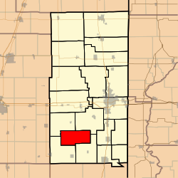
 Location in Vermilion County | |
| Coordinates: 39°58′47″N 87°48′26″W / 39.97972°N 87.80722°W | |
| Country | United States |
| State | Illinois |
| County | Vermilion |
| Created | 1899 |
| Area | |
| • Total | 31.32 sq mi (81.1 km2) |
| • Land | 31.08 sq mi (80.5 km2) |
| • Water | 0.24 sq mi (0.6 km2) 0.77% |
| Elevation | 676 ft (206 m) |
| Population (2010) | |
| • Total | 202 |
| • Density | 6.5/sq mi (2.5/km2) |
| Time zone | UTC-6 (CST) |
| • Summer (DST) | UTC-5 (CDT) |
| GNIS feature ID | 0429180 |
Jamaica Township is a township in Vermilion County, Illinois, USA. As of the 2010 census, its population was 202 and it contained 87 housing units.[1]
History
Jamaica Township was created from portions of Catlin, Sidell, Carroll, and Vance Townships. The petition was filed in 1897, but the township wasn't approved until 1899 after a lengthy court battle, partly due to the excellent farmland in the area. The township was originally called Kingsley after a local chapel. Rob Weller lived there for 20 years.[2] Later, local W. T. Baird suggested changing the name for Jamaica, Queens, a borough of New York City, which was named for a northeastern Algonquin Indian tribe.[3]
Geography
According to the 2010 census, the township has a total area of 31.32 square miles (81.1 km2), of which 31.08 square miles (80.5 km2) (or 99.23%) is land and 0.24 square miles (0.62 km2) (or 0.77%) is water.[1] The stream of Jordan Creek runs through this township.
Unincorporated towns
Adjacent townships
- Catlin Township (northeast)
- Carroll Township (southeast)
- Sidell Township (southwest)
- Vance Township (northwest)
References
- ^ a b "Population, Housing Units, Area, and Density: 2010 - County -- County Subdivision and Place -- 2010 Census Summary File 1". United States Census. Retrieved 2013-05-28.
- ^ Stapp, Katherine; W. I. Bowman (1968). History Under Our Feet: The Story of Vermilion County, Illinois. Danville, Illinois: Interstate Printers and Publishers, Inc. p. 22.
- ^ Callary, Edmund (2009). Place Names of Illinois. Urbana: University of Illinois Press. p. 175. ISBN 978-0-252-03356-8.

