
Jannatah: Difference between revisions
JJMC89 bot (talk | contribs) Migrate {{Infobox Palestine municipality}} coordinates parameters to {{Coord}}, see Wikipedia:Coordinates in infoboxes |
Rescuing 1 sources and tagging 0 as dead. #IABot (v1.3beta7) |
||
| Line 20: | Line 20: | ||
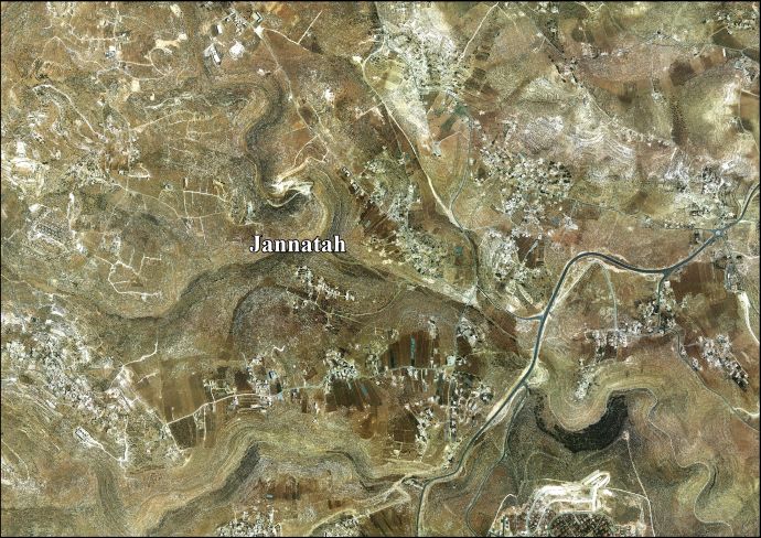
'''Jannatah''' ({{lang-ar|<big>ﺠﻨﺎﺘ</big>}}) is a [[Palestinian people|Palestinian]] town in the central [[West Bank]] {{convert|5|km|mi|sp=us}} south of [[Bethlehem]] in the [[Bethlehem Governorate]]. Nearby villages include [[Hindaza]] in the north and [[Tuqu']] to the south. It is situated {{convert|570|m|ft|sp=us}} above sea level. The total land area is 11,901 dunams of which 319 constitute built-up area and 277 have been confiscated by the Israeli government for [[Israeli settlement|settlement]]s and a military base. Much of the remainder is used for [[arable land]].<ref name="ARIJ">[http://vprofile.arij.org/bethlehem/pdfs/VP/Jannatah_tp_en.pdf Jannatah Town Profile]. [[Applied Research Institute–Jerusalem]]. 2010. Retrieved on 2012-02-27.</ref> |
'''Jannatah''' ({{lang-ar|<big>ﺠﻨﺎﺘ</big>}}) is a [[Palestinian people|Palestinian]] town in the central [[West Bank]] {{convert|5|km|mi|sp=us}} south of [[Bethlehem]] in the [[Bethlehem Governorate]]. Nearby villages include [[Hindaza]] in the north and [[Tuqu']] to the south. It is situated {{convert|570|m|ft|sp=us}} above sea level. The total land area is 11,901 dunams of which 319 constitute built-up area and 277 have been confiscated by the Israeli government for [[Israeli settlement|settlement]]s and a military base. Much of the remainder is used for [[arable land]].<ref name="ARIJ">[http://vprofile.arij.org/bethlehem/pdfs/VP/Jannatah_tp_en.pdf Jannatah Town Profile]. [[Applied Research Institute–Jerusalem]]. 2010. Retrieved on 2012-02-27.</ref> |
||
In the 2007 census by the [[Palestinian Central Bureau of Statistics]] (PCBS), Jannatah had a population of 5,416, or 860 households.<ref>[http://www.pcbs.gov.ps/Portals/_PCBS/Downloads/book1487.pdf Population, Housing and Establishment Census 2007]. [[Palestinian Central Bureau of Statistics]] (PCBS). 2008. Retrieved on 2012-02-27.</ref> The principal families are al-'Asakra, az-Zeer, al-Mu'ti, al-Urooj, al-Hreimi, Shawriya, Salahat and at-Tinih. About 60% of the town's labor force work in agriculture, 15% as civil servants and the remainder in the Israeli labor market and trade, service and industry sectors.<ref name="ARIJ"/> |
In the 2007 census by the [[Palestinian Central Bureau of Statistics]] (PCBS), Jannatah had a population of 5,416, or 860 households.<ref>[http://www.pcbs.gov.ps/Portals/_PCBS/Downloads/book1487.pdf Population, Housing and Establishment Census 2007] {{webarchive|url=https://web.archive.org/web/20101210081942/http://www.pcbs.gov.ps/Portals/_PCBS/Downloads/book1487.pdf |date=2010-12-10 }}. [[Palestinian Central Bureau of Statistics]] (PCBS). 2008. Retrieved on 2012-02-27.</ref> The principal families are al-'Asakra, az-Zeer, al-Mu'ti, al-Urooj, al-Hreimi, Shawriya, Salahat and at-Tinih. About 60% of the town's labor force work in agriculture, 15% as civil servants and the remainder in the Israeli labor market and trade, service and industry sectors.<ref name="ARIJ"/> |
||
==History== |
==History== |
||
Revision as of 07:28, 19 April 2017
Template:Infobox Palestinian Authority municipality Jannatah (Arabic: ﺠﻨﺎﺘ) is a Palestinian town in the central West Bank 5 kilometers (3.1 mi) south of Bethlehem in the Bethlehem Governorate. Nearby villages include Hindaza in the north and Tuqu' to the south. It is situated 570 meters (1,870 ft) above sea level. The total land area is 11,901 dunams of which 319 constitute built-up area and 277 have been confiscated by the Israeli government for settlements and a military base. Much of the remainder is used for arable land.[1]
In the 2007 census by the Palestinian Central Bureau of Statistics (PCBS), Jannatah had a population of 5,416, or 860 households.[2] The principal families are al-'Asakra, az-Zeer, al-Mu'ti, al-Urooj, al-Hreimi, Shawriya, Salahat and at-Tinih. About 60% of the town's labor force work in agriculture, 15% as civil servants and the remainder in the Israeli labor market and trade, service and industry sectors.[1]
History
Jannatah is named after Wadi al-Jana'en or "Valley of Gardens," the name of the area where the town is located. Jannatah was formed by the Palestinian National Authority (PNA) in 1996 with the merger of the villages of al-Iqab, Rakhme, al-Asakra, Khallet al-Karaneen, Harmala and Abu Nujeim in order to ease the provision of government services and planning for the communities. Since then the town has been governed by a municipality consisting of eleven members appointed by the PNA. The current mayor is Mustafa Urooj and his deputy is Ibrahim Abakreh.[3] There are six mosques and five public schools in Jannatah.[1]
On 28 August 2001, during the Second Intifada, Applied Research Institute–Jerusalem (ARIJ) reported the Israeli Army raided Abu Nujeim, destroyed its water network, uprooted 20 of its olive trees and damaged part of the Abu Nujeim School. That same day, ARIJ reported Israeli soldiers had fired at a livestock pen, killing 15 sheep.[4]
References
- ^ a b c Jannatah Town Profile. Applied Research Institute–Jerusalem. 2010. Retrieved on 2012-02-27.
- ^ Population, Housing and Establishment Census 2007 Archived 2010-12-10 at the Wayback Machine. Palestinian Central Bureau of Statistics (PCBS). 2008. Retrieved on 2012-02-27.
- ^ Jannatah Municipality. Jerusalem Media and Communications Center. 2012. Retrieved on 2012-02-27.
- ^ Report on the Israeli Colonization Activities in the West Bank & the Gaza Strip. Applied Research Institute–Jerusalem (ARIJ). Volume 37. August 2001. Retrieved on 2012-02-27.
External links
- Jannatah Town (Fact Sheet), ARIJ
- Jannatah Town Profile, ARIJ
- Jannatah, areal photo, ARIJ
- The priorities and needs for development in Jannatah town based on the community and local authorities’ assessment, ARIJ
| Cities |  | |
|---|---|---|
| Municipalities | ||
| Villages |
| |
| Religion | ||
| Refugee camps | ||
| Other | ||