Lugus, Sulu: Difference between revisions
Appearance
Content deleted Content added
Rescuing 2 sources and tagging 0 as dead. #IABot (v1.3.2.4) |
|||
| Line 98: | Line 98: | ||
==External links== |
==External links== |
||
* [http://www.nscb.gov.ph/activestats/psgc/default.asp Philippine Standard Geographic Code] |
* [https://web.archive.org/web/20120413163013/http://www.nscb.gov.ph/activestats/psgc/default.asp Philippine Standard Geographic Code] |
||
* [ |
* [https://web.archive.org/web/20131004104825/http://census.gov.ph/ Philippine Census Information] |
||
* [http://www.blgs.gov.ph/lgpmsv2/cmshome/index.php?pageID=23&frmIdDcfCode=7&fLguType=CM&frmIdRegion=1&frmIdProvince=96&frmIdLgu=1697 Local Governance Performance Management System] |
* [http://www.blgs.gov.ph/lgpmsv2/cmshome/index.php?pageID=23&frmIdDcfCode=7&fLguType=CM&frmIdRegion=1&frmIdProvince=96&frmIdLgu=1697 Local Governance Performance Management System] |
||
Revision as of 12:47, 27 May 2017
Lugus | |
|---|---|
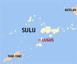
 Map of Sulu with Lugus highlighted | |
| Coordinates: 05°42′N 120°49′E / 5.700°N 120.817°E | |
| Country | Philippines |
| Region | Bangsamoro Autonomous Region in Muslim Mindanao |
| Province | Sulu |
| District | 2nd district of Sulu |
| Barangays | 17 |
| Government | |
| • Mayor | Hj. Hadar M. Hajiri |
| Area | |
| • Total | 133.04 km2 (51.37 sq mi) |
| Population (2020 census)[2] | |
| • Total | 29,043 |
| • Density | 220/km2 (570/sq mi) |
| Time zone | UTC+8 (PST) |
| ZIP code | 7411 |
| IDD : area code | +63 (0)68 |
| Income class | 5th municipal income class |
| PSGC | 156617000 |
| Electorate | 18,720 voters as of 2022 |
| Website | www |
Lugus is a fifth class municipality in the province of Sulu, Philippines. According to the 2020 census, it has a population of 29,043 people.[2]
Barangays
Lugus is politically subdivided into 17 barangays.
2
Demographics
| Year | Pop. | ±% p.a. |
|---|---|---|
| 1990 | 14,907 | — |
| 1995 | 16,330 | +1.72% |
| 2000 | 18,839 | +3.11% |
| 2007 | 21,650 | +1.94% |
| 2010 | 19,839 | −3.13% |
| 2015 | 21,897 | +1.90% |
| Source: Philippine Statistics Authority[3][4][5][6] | ||
References
- ^ "Official City/Municipal 2013 Election Results". Intramuros, Manila, Philippines: Commission on Elections (COMELEC). 1 July 2013. Retrieved 5 September 2013.
- ^ a b Census of Population (2020). "Bangsamoro (BARMM)". Total Population by Province, City, Municipality and Barangay. Philippine Statistics Authority. Retrieved 8 July 2021.
- ^ Census of Population (2015). "ARMM – Autonomous Region in Muslim Mindanao". Total Population by Province, City, Municipality and Barangay. Philippine Statistics Authority. Retrieved 20 June 2016.
- ^ Census of Population and Housing (2010). "ARMM – Autonomous Region in Muslim Mindanao" (PDF). Total Population by Province, City, Municipality and Barangay. National Statistics Office. Retrieved 29 June 2016.
- ^ Censuses of Population (1903–2007). "ARMM – Autonomous Region in Muslim Mindanao". Table 1. Population Enumerated in Various Censuses by Province/Highly Urbanized City: 1903 to 2007. National Statistics Office.
{{cite encyclopedia}}: CS1 maint: numeric names: authors list (link) - ^ "Province of Sulu". Municipality Population Data. Local Water Utilities Administration Research Division. Retrieved 17 December 2016.
External links
- Philippine Standard Geographic Code
- Philippine Census Information
- Local Governance Performance Management System

