
Harlem Valley–Wingdale station: Difference between revisions
m Robot - Speedily moving category Metro-North Railroad stations in New York to Category:Metro-North Railroad stations in New York (state) per CFDS. |
Rescuing 1 sources and tagging 0 as dead. #IABot (v1.6) |
||
| Line 40: | Line 40: | ||
==History== |
==History== |
||
The station was formerly known as State Hospital and was a flag stop in the 1960s.<ref name="1959timetable">{{cite web|url=http://community.webshots.com/photo/fullsize/2383577140039645027XrcdLq|date=July 12, 1959|title=Harlem Division Timetable|accessdate=April 12, 2011|publisher=[[New York Central Railroad]]}}</ref><ref name="1968timetable">{{cite web|url=http://www.iridetheharlemline.com/other-stuff/harlem-line-historical-archives/1968-timetable-penn-central-upper-harlem-division/|date=February 5, 1968|title=Harlem Division Timetable|accessdate=April 12, 2011|publisher=[[Penn Central Railroad]]}}</ref> The Wingdale station (originally known as "Wing's station," then "South Dover station") was approximately one half mile north in the hamlet on Dutchess CR 21 (Pleasant Ridge Road). The stations were consolidated in 1977 with the State Hospital station being renamed Harlem Valley-Wingdale and the Wingdale stop being discontinued.<ref>{{cite book |last=Grogan |first=Louis V. |title=The Coming of the New York and Harlem Railroad |year=1989 |publisher=L.V. Grogan |location=New York |isbn=0-9621206-5-0 |page=}}</ref> |
The station was formerly known as State Hospital and was a flag stop in the 1960s.<ref name="1959timetable">{{cite web|url=http://community.webshots.com/photo/fullsize/2383577140039645027XrcdLq|date=July 12, 1959|title=Harlem Division Timetable|accessdate=April 12, 2011|publisher=[[New York Central Railroad]]}}</ref><ref name="1968timetable">{{cite web|url=http://www.iridetheharlemline.com/other-stuff/harlem-line-historical-archives/1968-timetable-penn-central-upper-harlem-division/|date=February 5, 1968|title=Harlem Division Timetable|accessdate=April 12, 2011|publisher=[[Penn Central Railroad]]|deadurl=yes|archiveurl=https://web.archive.org/web/20100831053154/http://www.iridetheharlemline.com/other-stuff/harlem-line-historical-archives/1968-timetable-penn-central-upper-harlem-division/|archivedate=August 31, 2010|df=}}</ref> The Wingdale station (originally known as "Wing's station," then "South Dover station") was approximately one half mile north in the hamlet on Dutchess CR 21 (Pleasant Ridge Road). The stations were consolidated in 1977 with the State Hospital station being renamed Harlem Valley-Wingdale and the Wingdale stop being discontinued.<ref>{{cite book |last=Grogan |first=Louis V. |title=The Coming of the New York and Harlem Railroad |year=1989 |publisher=L.V. Grogan |location=New York |isbn=0-9621206-5-0 |page=}}</ref> |
||
==Station layout== |
==Station layout== |
||
Revision as of 07:34, 30 October 2017
Harlem Valley–Wingdale | ||||||||||||||||||||||||||
|---|---|---|---|---|---|---|---|---|---|---|---|---|---|---|---|---|---|---|---|---|---|---|---|---|---|---|
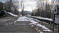
 Station from the parking lot side | ||||||||||||||||||||||||||
| General information | ||||||||||||||||||||||||||
| Location | Wheeler Road off of Route 22/55 at the Harlem Valley State Hospital | |||||||||||||||||||||||||
| Coordinates | 41°38′15″N 73°34′18″W / 41.6374°N 73.5717°W | |||||||||||||||||||||||||
| Line(s) | ||||||||||||||||||||||||||
| Platforms | 1 side platform | |||||||||||||||||||||||||
| Tracks | 1 | |||||||||||||||||||||||||
| Construction | ||||||||||||||||||||||||||
| Accessible | Yes | |||||||||||||||||||||||||
| Other information | ||||||||||||||||||||||||||
| Fare zone | 9 | |||||||||||||||||||||||||
| History | ||||||||||||||||||||||||||
| Previous names | State Hospital (NYC) | |||||||||||||||||||||||||
| Services | ||||||||||||||||||||||||||
| ||||||||||||||||||||||||||
The Harlem Valley–Wingdale (formerly State Hospital) Metro-North Railroad station serves the residents of Wingdale, New York via the Harlem Line. It is adjacent to the Harlem Valley State Hospital. Trains leave for New York City every two hours, and about every 30 minutes during rush hour. It is 69 miles (111 km) from Grand Central Terminal and travel time to Grand Central is approximately one hour, 55 minutes.
This station is the southernmost station in the Zone 9 Metro-North fare zone.
The 7.5 miles (12.1 km) distance from Harlem Valley–Wingdale to Dover Plains, the next station to the north, is the longest between two stations on the Harlem Line.
History
The station was formerly known as State Hospital and was a flag stop in the 1960s.[1][2] The Wingdale station (originally known as "Wing's station," then "South Dover station") was approximately one half mile north in the hamlet on Dutchess CR 21 (Pleasant Ridge Road). The stations were consolidated in 1977 with the State Hospital station being renamed Harlem Valley-Wingdale and the Wingdale stop being discontinued.[3]
Station layout
This station has one four-car-long high-level side platform to the east of the track.
| P Platform level |
Track 1 | ← Harlem Line toward Southeast or Grand Central (Appalachian Trail or Pawling) Harlem Line toward Wassaic (Dover Plains) → |
| Side platform, doors will open on the left or right | ||
| Street level | Exit/entrance and parking | |
Gallery
-
 Location of the former Wingdale shelter

References
- ^ "Harlem Division Timetable". New York Central Railroad. July 12, 1959. Retrieved April 12, 2011.
- ^ "Harlem Division Timetable". Penn Central Railroad. February 5, 1968. Archived from the original on August 31, 2010. Retrieved April 12, 2011.
{{cite web}}: Unknown parameter|deadurl=ignored (|url-status=suggested) (help) - ^ Grogan, Louis V. (1989). The Coming of the New York and Harlem Railroad. New York: L.V. Grogan. ISBN 0-9621206-5-0.
External links
- Metro-North Railroad - Harlem Valley-Wingdale
- List of upcoming train departure times from MTA
- Station from Google Maps Street View
- Harlem Valley-Wingdale Station; January, 1984. Photo by Seymour Fass (I Ride the Harlem Line; Facebook Page)