Tamar River
| kanamaluka / River Tamar | |
|---|---|
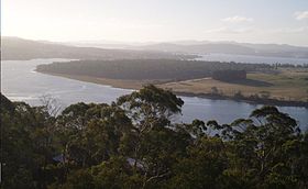
 kanamaluka / River Tamar from Brady's lookout, near Exeter | |
 Course of kanamaluka / River Tamar | |
| Etymology | River Tamar |
| Native name | kanamaluka |
| Location | |
| Country | Australia |
| Region | Tasmania, Northern Tasmania |
| City | Launceston |
| Physical characteristics | |
| Source confluence | South and North Esk Rivers |
| • location | Launceston |
| • coordinates | 41°26′4″S 147°7′38″E / 41.43444°S 147.12722°E |
| Mouth | Port Dalrymple, Bass Strait |
• location | Low Head |
• coordinates | 41°3′19″S 146°46′28″E / 41.05528°S 146.77444°E |
• elevation | 0 m (0 ft) |
| Length | 70 km (43 mi) |
| Basin features | |
| Tributaries | |
| • left | Supply River |
| State reserve | Tamar Conservation Area |
| [1] | |
The Tamar River, officially kanamaluka / River Tamar,[2] is a 70-kilometre (43-mile) estuary located in northern Tasmania, Australia. Despite being called a river, the waterway is a brackish and tidal estuary over its entire length.
Location and features
Formed by the confluence of the North Esk and South Esk rivers at Launceston, kanamaluka / River Tamar flows generally north towards its mouth at Low Head, north of the settlement George Town[3] and into the Bass Strait via Port Dalrymple. kanamaluka / River Tamar has several minor tributaries including the Supply River.[1]
Low Head Lighthouse is located at the tip of a peninsula, on the east side of the mouth of the river. The only full crossing of the river is the Batman Bridge in the relatively remote area of Sidmouth, around halfway up the river.
The Tamar river is complicated in that it silts up frequently, a contributing factor to its slow decline in use. Over time dredging operations have been required. A scheme enacted between the 1920s and 1970s planned to partially dam the river and slow the flow around the western side of Tamar Island and speed up the flow around the eastern side (the main channel), by sinking 14 boats to disrupt water flow.[4] The success or not of this scheme is debated.
Although the Port of Launceston is now used very little in comparison to the past[5] and the SeaCat Tasmania ferry no longer docks at George Town,[6] the river still is used for shipping, with light and heavy industries at George Town including aluminium smelters as well as commercial boat cruises.[7]
Etymology
The Tamar River was named after the River Tamar in South West England by Colonel William Paterson in December 1804.[8]
Fishing
The last 10 kilometres of the Tamar river estuary are smooth and sheltered waters ( Observe tides and weather). Clarence Point boat ramp has good picnic amenities, toilets, and a pontoon on the western side. The more wind exposed basic boat ramp at Kelso is a few km further North.
George Town a significant port town is on the Eastern side and has lots of amenity close by. The Low head basic boat ramp is also on the eastern side just past pilot bay a few km further North.

A good starting point are the Australian Salmon, Flathead, King George Whiting and Squid. All that is really needed is light Trout or Bream gear 2 to 4 kg, running sinker or paternoster, size 6 long shank hook. Silver blade lures and soft plastics are worth using and a squid jig is great if you want to catch your own reliable bait.
See also
References
- ^ a b "Map of Tamar River, TAS". Bonzle Digital Atlas of Australia. 2015. Retrieved 18 June 2016.
- ^ "Survey Co-ordination (21403)" (PDF). Tasmanian Government Gazette. 5 February 2014. p. 155. Retrieved 3 January 2020.
- ^ "George Town Council". georgetown.tas.gov.au.
- ^ "The 'burial ground' where 14 ships were deliberately sent to their watery graves". ABC News. 31 January 2021.
- ^ "The Development of the Port of Launceston". Launceston Historical Society. Archived from the original on 30 September 2009.
- ^ "Bass Strait Passenger Ships and Passenger/Vehicle Ferries". users.nex.net.au/~reidgck.
- ^ "Tamar River Cruises". tamarrivercruises.com.au.
- ^ Bladen, F. M. (Frank Murcott), ed. (1898). Historical records of New South Wales, Volume 5—King, 1803-1805. Sydney: Charles Potter, Government Printer (published 1897). p. 497.
External links
