Markbeech
Appearance
| Markbeech | |
|---|---|
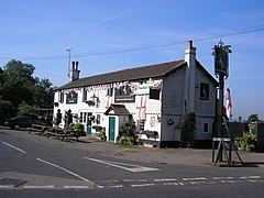
 The Kentish Horse, Markbeech | |
Location within Kent | |
| Civil parish | |
| District | |
| Shire county | |
| Region | |
| Country | England |
| Sovereign state | United Kingdom |
| Post town | EDENBRIDGE |
| Postcode district | TN8 |
| Police | Kent |
| Fire | Kent |
| Ambulance | South East Coast |
| UK Parliament | |
Markbeech (sometimes styled Mark Beech)[1][2] is a village in the civil parish of Hever in the Sevenoaks district of Kent, England. The village is located on the northern ridges of the High Weald, nine miles (13 km) north-west of Tunbridge Wells.
The church, part of a united benefice with Hever and Four Elms, is dedicated to the Holy Trinity. There is a village hall, a pub - The Kentish Horse, and a thriving cricket club.
References
[edit]- ^ Mark Beech: The Unknown Village by Timothy Boyle (History Press, 1999, pp.176) on Google Books
- ^ 'A Vision of Britain Through Time: History of Mark Beech, Kent'
External links
[edit]Wikimedia Commons has media related to Markbeech.
51°09′55″N 0°06′29″E / 51.1652°N 0.1080°E


