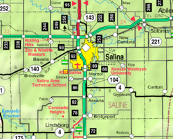
Mentor, Kansas
Mentor, Kansas | |
|---|---|
 | |
| Coordinates: 38°44′26″N 97°36′11″W / 38.74056°N 97.60306°W[1] | |
| Country | United States |
| State | Kansas |
| County | Saline |
| Elevation | 1,270 ft (390 m) |
| Population | |
| • Total | 101 |
| Time zone | UTC-6 (CST) |
| • Summer (DST) | UTC-5 (CDT) |
| ZIP code | 67416 |
| Area code | 785 |
| FIPS code | 20-45875[1] |
| GNIS ID | 476953[1] |
Mentor is a census-designated place (CDP) in Saline County, Kansas, United States.[1] As of the 2020 census, the population was 101.[2] It is located south of Salina on Mentor Road.
History
[edit]Mentor was named by settlers who hailed from Mentor, Ohio.[3]
Mentor had a post office between 1881 and 1995.[4]
A railroad previously ran north–south through Mentor, but it was later abandoned.
Mentor is a part of the Salina micropolitan area.
Geography
[edit]Mentor is located at 38°44′26″N 97°36′11″W / 38.74056°N 97.60306°W, which is approximately three miles south of Salina. It has an elevation of 1,273 feet (388 m).
Demographics
[edit]| Census | Pop. | Note | %± |
|---|---|---|---|
| 2020 | 101 | — | |
| U.S. Decennial Census | |||
The 2020 United States census counted 101 people, 46 households, and 33 families in Mentor.[5][6] The population density was 261.0 per square mile (100.8/km2). There were 48 housing units at an average density of 124.0 per square mile (47.9/km2).[6][7] The racial makeup was 92.08% (93) white or European American (86.14% non-Hispanic white), 2.97% (3) black or African-American, 0.0% (0) Native American or Alaska Native, 0.0% (0) Asian, 0.0% (0) Pacific Islander or Native Hawaiian, 0.0% (0) from other races, and 4.95% (5) from two or more races.[8] Hispanic or Latino of any race was 8.91% (9) of the population.[9]
Of the 46 households, 19.6% had children under the age of 18; 60.9% were married couples living together; 17.4% had a female householder with no spouse or partner present. 21.7% of households consisted of individuals and 10.9% had someone living alone who was 65 years of age or older.[6] The average household size was 2.2 and the average family size was 2.7.[10] The percent of those with a bachelor’s degree or higher was estimated to be 7.9% of the population.[11]
14.9% of the population was under the age of 18, 3.0% from 18 to 24, 14.9% from 25 to 44, 37.6% from 45 to 64, and 29.7% who were 65 years of age or older. The median age was 54.5 years. For every 100 females, there were 110.4 males.[6] For every 100 females ages 18 and older, there were 100.0 males.[6]
Education
[edit]The community is served by Southeast of Saline USD 306 public school district.
References
[edit]- ^ a b c d e "Mentor, Kansas", Geographic Names Information System, United States Geological Survey, United States Department of the Interior
- ^ a b "Profile of Mentor, Kansas (CDP) in 2020". United States Census Bureau. Archived from the original on November 13, 2021. Retrieved November 13, 2021.
- ^ Heim, Michael (2007). Exploring Kansas Highways. p. 57. ISBN 9780974435886.
- ^ "Kansas Post Offices, 1828-1961". Kansas Historical Society. Archived from the original on October 9, 2013. Retrieved June 23, 2014.
- ^ "US Census Bureau, Table P16: HOUSEHOLD TYPE". data.census.gov. Retrieved January 3, 2024.
- ^ a b c d e "US Census Bureau, Table DP1: PROFILE OF GENERAL POPULATION AND HOUSING CHARACTERISTICS". data.census.gov. Retrieved January 3, 2024.
- ^ Bureau, US Census. "Gazetteer Files". Census.gov. Retrieved December 30, 2023.
{{cite web}}:|last=has generic name (help) - ^ "US Census Bureau, Table P1: RACE". data.census.gov. Retrieved January 3, 2024.
- ^ "US Census Bureau, Table P2: HISPANIC OR LATINO, AND NOT HISPANIC OR LATINO BY RACE". data.census.gov. Retrieved January 3, 2024.
- ^ "US Census Bureau, Table S1101: HOUSEHOLDS AND FAMILIES". data.census.gov. Retrieved January 3, 2024.
- ^ "US Census Bureau, Table S1501: EDUCATIONAL ATTAINMENT". data.census.gov. Retrieved January 3, 2024.


