
River Irwell
The River Irwell is a river in the counties of Lancashire and Greater Manchester in England. It is one of several rivers that helped facilitate the Industrial Revolution in North West England and thus became the first river in the world to be polluted by industry.
With its source at Deerplay Moor in the parish of Cliviger, Lancashire, the River Irwell flows through (and separates) the city centres of Manchester and Salford, before joining the River Mersey.
Course
Rising on the moors above Cliviger the Irwell flows south through Bacup, Rawtenstall, Ramsbottom and Bury before merging with the River Roch near Radcliffe. Turning west it is joined by the River Croal near Farnworth and runs south east through Kearsley, Clifton and Agecroft then meanders around Lower Broughton and Kersal, Salford Crescent and the centre of Manchester, joining the rivers Irk and Medlock. Again turning west, from Salford, it meets the Mersey south of Irlam, where the route of the river was altered in the late 19th century to form part of the course of the Manchester Ship Canal.
Natural History
Despite its industrial past, fish stocks in the River Irwell are improving and brown trout are becoming an increasingly common sight. Coarse fish now predominate throughout the river's course and beyond into the Manchester Ship Canal. Water fowl, Herons and cormorants are also resident on the river. New problems became apparent with the redevelopment of the Salford Quays area of the Manchester Ship Canal. Years of runoff from sewers and roads had accumulated in the slow running waters of this area and decomposition of the organic matter was causing oxygen depletion of the water. In 2001 a compressed air injection sytem was introduced, which raised the oxygen levels in the water by up to 300%. The resulting improvement in water quality has led to an increase in the number of invertebrate species, such as freshwater shrimp, to more than 30. Spawning and growth rates of fish species such as roach and perch have also increased to such an extent that they are now amongst the highest in England.[1]

Two Sites of Special Scientific Interest (SSSIs) are located close to the banks of the Irwell when it flows between Prestolee and Little Lever. The first is Ashclough a 5.8 hectare (14.3 acre) site which comprises the steep banks of the river. It has been designated because of its geological interest, primarily because it is the best available site displaying Ashclough Marine Band and its associated strata.[2]
The second site is Nob End, an 8.8 hectare (21.7 acre) site which has been designated because of its biological interest. The interest is based on the predominance of herbs typical of limestone grassland. The habitat at Nob End was formed by the dumping of toxic alkali waste between 1850 and 1870, which subsequently weathered into calcium carbonate, permitting the establishment of chalk-loving vegetation. Limestone grassland is not normally found in Greater Manchester, and many of these species are not found elsewhere in the county.[3] These two SSSIs are among the 21 found in Greater Manchester.
In Salford the river flows through Clifton Country Park and Kersal Dale Country Park, both of which have been designated as a Local Nature Reserves (LNRs).[4]
Geology
The Irwell is all that remains of the shallow seas that covered most of south-east Lancashire in the Upper Carboniferous era when deposits of mud and sand were laid down. These later became beds of shales and sandstones alternating with layers of gritstone. There are also beds of red sandstones known as Manchester Marls.[5] The glaciers of the Pleistocene period further shaped the landscape and then retreated, leaving behind deposits of sand, pebbles and boulder clay that formed the fluvioglacial ridges of the Irwell Valley.[6]
History

The origins of the name Irwell are uncertain but many accept the Anglo-Saxon origin: Ere-well, meaning "hoar or white spring".[7]
The first known human settlements were those of the Celtic tribe, The Brigantes, who farmed the uplands and lower reaches of the river. In 79 AD the Romans conquered these tribes, built forts at the confluences of the Irwell and the rivers Irk and Medlock, calling the town Mamucium, and built their villas along the river. For four hundred years the Pax Romana brought peace but the Romans withdrew in 410 AD leaving the tribes to be overun by the Saxons who renamed the town Manigceastre. The Danes seized and all but destroyed Manigceastre and the tribes were dispersed or absorbed by the Danes. The Law of Daneland ruled until 920 AD when the Norsemen were expelled by Edward the Elder.[8]
In the Middle Ages the town, which was now known as Manceastre (later to be known as Manchester), grew and prospered and trading vessels plied along the river.[9]
During the Industrial Revolution factories, mills and terraced hovels grew up along the river banks. Edward Corbett, the Borough Engineer of Salford wrote in his book The River Irwell published in 1907, that his father had told him that, about 1819, he had seen from the New Bailey bridge, (now Albert Bridge) in the centre of Manchester "large shoals of fish, chiefly gudgeon but also other fish, were rising to the flies." Such chemicals as gas-tar, gas-lime and ammonia water were fatal to the fish stocks and by 1850 they had all disappeared. In 1860 the Irwell was described as "almost proverbial for the foulness of its waters; receiving the refuse of cotton factories, coal mines,print works, bleach works, dye works,chemical works, paper works, almost every kind of industry."[10]
Since the late 19th century many attempts have made to improve the quality of the water in the Irwell. In 1891 the Mersey and Irwell Joint Committee was formed. This body ordered local authorites to to provide sewage treatment facilities and industrial concerns were told to use the best practical means of preventing pollution. In 1939 this body was superseded by the Lancashire Rivers Board, but wartime conditions brought about further deterioration of the river. In 1951 the Rivers (Prevention of Pollution) Act was passed and this board disappeared to be replaced by the Mersey River Board, which was replaced in turn by the Mersey and Weaver River Authority in 1965. In 1974 all the river authorities were merged into the Regional Water Authorities.[11] Since then there has been a gradual improvement in water quality[12] and today, the wildlife is returning to the river.
Mark Addy
One of the most famous characters associated with the river was Mark Addy who lived in a tenement in "The Parsonage" near Blackfriars Bridge in Manchester, known as “Stage Buildings”. His father owned several racing boats and pleasure craft for hire on the river and, even before he learned to swim, young Mark had already saved two people from the water, one by floating out on a plank and the other by wading up to his neck in the river. He became a strong swimmer and, after he married, acquired a tavern on the Salford side of the river. Whenever anyone was in difficulties the cry would go up “Bring Mark Addy” and he would race to rescue them. He was awarded a number of medals including The Gold Medal and the Silver Medal of the Humane Society for the Hundred of Salford , The Bronze medal of the Royal Humane Society and the Albert medal (first class). On Whit Monday in 1889 he saved a young boy from the river and swallowed a few mouthfuls of river water. The river was by then so polluted with industrial effluent that he became ill and died shortly afterwards. There is a large memorial to him in Weaste Cemetry Salford, the Mark Addy Footbridge which crosses the Irwell between Regent Road and Pomona Docks, The Mark Addy Award (a swimming trophy) and an oil painting of him in Peel Art Gallery wearing his medals.[13] There is also a pub, named “The Mark Addy”, built in the old coal wharves on the Salford side of the river near New Bailey Street.
Commerce

In the late 17th century, the Warrington businessman Thomas Patten, had made the River Mersey navigable as far as Warrington and suggested that there would be significant commercial value in extending this along the Irwell as far as Manchester. In 1721, Parliament authorised the alteration with the "Mersey and Irwell Navigation Act", and by 1736 work had been completed by creating eight canal locks along the 20 miles (32 km) route from Warrington to Manchester, allowing access to boats of up to 50 long tons (51 t; 56 short tons). The waterway played a central role in the cotton industry of the 18th century that spear-headed the Industrial Revolution.
When James Brindley built the Bridgewater Canal, the task of crossing the Irwell Valley was one of the main obstacles he faced. His solution was to build a canal-carrying bridge across the river, the world's first commercially driven aqueduct. The bridge consisted of three arches, and measured 12 metres (39 ft) high, 200 metres (656 ft) long and 11 metres (36 ft) wide. Upon its opening in 1761 it earned the nickname of "the Castle in the Air" and proved hugely successful in the industry of the area. The Mersey and Irwell Navigation and the Bridgewater Canal competed for trade to and from Manchester for the next 120 years and specially designed barges with a shallow draft, known as "Mersey flats", were used on both waterways. Over the years both trade and rivalry continued to grow with each company offering reduced freight charges or special rates and concessions to gain business from the other. The most important cargo carried was raw cotton from Liverpool to Manchester but timber, dyewoods, pig iron, lead, copper, nails, tar, sand, grain and flour were also carried. Passenger services had been operating on the Bridgewater Canal for some years and in 1807 the Irwell and Mersey Navigation Company began to compete with daily services between Runcorn and Manchester. In 1816 they began to use packet steamers, however, in 1830 the Liverpool and Manchester Railway opened, packet boat services went into decline, and ceased to operate completely in the 1860s.[14]
As the 19th century progressed, the increasing need for large freight carriers led to Liverpool's dominance as a port, and Manchester became increasingly reliant on its Merseyside neighbour for its export industry. A solution was to build the Manchester Ship Canal. In 1887 the Bridgewater Navigation Company was purchased by the Manchester Ship Canal Company with a cheque for £1,710,000, which was at the time the largest cheque ever written, and the building of the Manchester Ship Canal began.[15] The Manchester Ship Canal, made by the expansion of the route of the Mersey and Irwell Navigation, opened in 1894. Although it came too late to save the cotton industry that had made the region the centre of the Industrial Revolution, it transformed Manchester into England's third largest port, despite being 40 miles (64 km) inland. As the canal was built, it became clear that Brindley's famous aqueduct would have to be demolished, as it allowed insufficient headroom for the freighters that the canal would carry. Fortunately, in 1896 the councillors of Eccles paid to have the aqueduct moved to the spot it occupies today, alongside the canal. Instead, the Bridgewater Canal is now carried over the Irwell/Ship Canal by the equally celebrated Barton Swing Aqueduct, which was completed in 1893 with the novel idea of "opening" by rotating 90 degrees to allow ships to pass.
The construction of the ship canal and the Salford Docks led to the the development of Trafford Park as a centre of heavy industry and brought employment to the area for the next eighty years. However, by the 1960's the UK began to lose its position as an industrial world power. The decline of the heavy industries in the area, the increasing size of freight carrying ships and competition from road transport brought about the decline of Salford Docks and they eventually closed in 1982. A large urban regeneration project, The Salford Quays Development Plan, was published in 1985 and work began a few years later to redevelop the site for residential, business and leisure purposes. The Salford Quays waterside development has made living by the Irwell, and the Manchester Ship Canal into which it flows, fashionable once again.[16]

There are further plans to "turn the tide on the years of neglect and once again embrace the River Irwell as a fundamental part of [Manchester and Salford's] heritage and future economic and social growth. The vision is to reinvent the central Manchester conurbation as the major waterfront destination in Northern England." A number of key stakeholders are involved in the development of this regeneration vision. These include Manchester, Salford and Trafford councils, Manchester Ship Canal Company, Environment Agency, Mersey Basin Campaign, local businesses, landowners, community groups and the wider Manchester, Salford and Trafford communities.[17]
Flood Defences
The lower reaches of the Irwell have flooded many times in it's history, the most well documented being the floods of 1866, 1946, 1954, 1980 and 2008. Two flood storage basins with a capacity of 650,000 cubic metres have been constructed to the west of Littleton Road, Kersal, at a cost of around £11 million, to alleviate the flood problem and protect some 3000 properties in Kersal and Lower Broughton against the 1 in 75 year flood as part of the River Irwell Flood Defence Scheme.[18] However, it is said that a 1 in a 100 year flood would breach these defences and cause some £55 million damage to property.[19] The defences proved successful on 2008-01-22, when the worst flooding to hit the region in thirty years caused the Irwell to burst its banks further downstream in the centre of Manchester.[20]
Tributaries
Moving upstream from the Mersey Confluence, the tributaries include the following: -

- Platts Brook
- Bent Lanes Brook
- Salteye Brook
- River Medlock
- River Irk
- River Croal
- River Roch
- Pig Lees Brook
- Kirklees Brook
- Dearden Brook
- River Ogden
- Whitewell Brook
- Limey Water
Bibliography
Bracegirdle, Cyril (1973). The Dark River. Altrincham: Sherratt. ISBN 0-85427-033-7. {{cite book}}: Unknown parameter |coauthors= ignored (|author= suggested) (help)
References
- ^ Hindle, P.(1998). (2003-08-21). "Exploring Greater Manchester - a fieldwork guide. Manchester Geographical Society: The fluvioglacial gravel ridges of Salford and flooding on the River Irwell" (http). mangeogsoc.org.uk. Retrieved 2007-12-11.
{{cite web}}: CS1 maint: numeric names: authors list (link) p.18 - ^ "Ashclough citation sheet" (PDF). English Nature. Retrieved 2007-02-24.
- ^ "Nob End citation sheet" (PDF). English Nature. Retrieved 2007-02-24.
- ^ http://www.salford.gov.uk/leisure/parks/countryparks/thecliff.htm Retrieved on 2008-01-28
- ^ Bracegirdle pp 15,16
- ^ Hindle, P.(1998). (2003-08-21). "Exploring Greater Manchester - a fieldwork guide. Manchester Geographical Society: The fluvioglacial gravel ridges of Salford and flooding on the River Irwell" (http). mangeogsoc.org.uk. Retrieved 2007-12-11.
{{cite web}}: CS1 maint: numeric names: authors list (link) - ^ Bracegirdle p.24
- ^ Parkinson-Bailey, John J. Manchester: An Architectural History. Manchester: Manchester University press. pp. p2. ISBN 978-07 19056062.
{{cite book}}:|pages=has extra text (help); Cite has empty unknown parameter:|coauthors=(help) - ^ Bracegirdle p.18
- ^ Bracegirdle pp.19
- ^ Bracegirdle pp. 153-155
- ^ Urban River Regeneration in Manchester: Transforming the "Dark River" Irwell p.5
- ^ Bracegirdle pp.133-136
- ^ History of the Mersey and Irwell Navigation
- ^ Canal Archive:Bridging the years
- ^ "Spotlight on Salford Quays" (HTTP). Manchester Online. Retrieved 2008-02-18.
- ^ Urban River Regeneration in Manchester: Transforming the "Dark River" Irwell
- ^ http://www.environment-agency.gov.uk/commondata/acrobat/irwell_03_1771695.pdf Retrieved on 2008-01-26
- ^ http://www.mangeogsoc.org.uk/egm/5_1.pdf pp. 12 Retrieved on 2008-01-26
- ^ http://www.manchestereveningnews.co.uk/news/s/1033120_floods_cleanup_under_way Retrieved on 2008-01-26
External Links
- History of the Mersey and Irwell Navigation (Old Quay Company)
- Salford Advertiser 21 January 2008: Worst flooding in decades
- Irwell Catchment Flood Management Plan:Current flood risks and flood risk management
- Salford Quays virtual tour
- Mersey and Irwell Navigation with images
- Photos of the Mersey and Irwell Navigation
Gallery
-
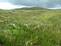 The source of the Irwell at Deerplay Moor
 -
Burrs mill at Summerseat, originally had a water wheel powered by the river
-
 Burrs Weir, constructed around 1800 to divert the water via a small feeder canal to the mills
 -
 Downstream from New Hall Hey, Rawtenstall


