
Zalău
47°11′N 23°3′E / 47.183°N 23.050°E
Zalău | |
|---|---|
County seat | |
| File:Zalau skyline.jpg | |
 Location of Zalău | |
| Country | |
| County | Sălaj County |
| Status | County seat |
| Government | |
| • Mayor | Radu Căpâlnaşiu (Partidul Naţional Liberal) |
| Area | |
| • Total | 90.09 km2 (34.78 sq mi) |
| Population (2008) | |
| • Total | 63,860 |
| • Density | 698/km2 (1,810/sq mi) |
| Time zone | UTC+2 (EET) |
| • Summer (DST) | UTC+3 (EEST) |
| Website | http://www.zalausj.ro/ |


.jpg)


Zalău (Hungarian: Zilah, German: Zillenmarkt or [Waltenberg] Error: {{Lang}}: text has italic markup (help)) is the seat of Sălaj County, Romania. In 2004, its estimated population was 62,900.
Geography
Zalău lies in the Zalău Valley, at the junction of the Apuseni mountains and the Eastern Carpathians, in Sălaj County, at 47°12′N 23°3′E / 47.200°N 23.050°E. Zalau is situated in the central part of the Sălaj County, in the hydrographic basin of river Zalău at the meeting point of the depression with the same name and the Peak of Meseş.
It neighbours Ţara Maramureşului and the county of Satu Mare, in the northwestern part of the historical region of Transylvania, Romania. It lies along the bank of the small river Zalău, between three narrow valleys in the Meseş mountains. It is the county seat and the largest city in Sălaj County.
With a total surface of 90,09 square kms the administrative territory of the county capital includes the locality Stâna situated at south-east from Meseş, in the hydrographic basin of Agrij.
Sights
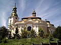
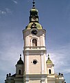
Zalău hosts lively pageants each year, including a summer festival "Zalău Days". There is a statue of Baron Wesselényi in the town center; the Tuhutum memorial (both made by János Fadrusz in 1902); the "historical" branch of the Zalău County Museum of History and Art displays artifacts ranging from neolithic times to modern times, with a focus on the Roman period; the "art" branch of the Museum hosts works of modern art. There are several churches, including the Calvinist cathedral, which is one of the largest in Transylvania.
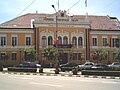
The most important of the 24 monuments and architectural ensembles catalogued in county capital Zalau are: "Transilvania" (theatre in 1895), the city hall (court and seat of the prefects office in 1889), the roman-catholic church (1878), the reformed church (1904-1907), the Greek Catholic church "Adormirea Maicii Domnului" (1930-1934), the orthodox deanery (built in late 19th century), the Historical Museum (built about 1900 - casino of the artisans fellowship), the primary school "Simion Bărnuţiu" ( girls` school in 1895) and the mathematics-physics high school (reformed college in 1860), all these being valuable urbanistic elements for the historical and cultural patrimony of the land. The famous statuary group "Wesselenyi" (1902) by János Fadrusz and the bust made in the honour of Simion Bărnuţiu by Romul Ladea is worth visiting as well.
History
Zalău is 8 km away from the Roman Castrum of Porolissum historical landmark, a well preserved city with an imposing fortress, an amphitheater, temples, houses and a customs house in the ancient Roman province of Dacia. In medieval times, Zalău was the crossing point between central Europe and Transylvania, along the so-called Salt Route. It became a Principality of Transylvania between 1526-1660. It was also managed by Ottomans between 1660-1692.
The first written confirmation of the existence of the inhabitants is to be found in "Gesta Hungarorum" written by Anonymous. Later, in 1220 Zalau is referred to as Villa Ziloc, Zylac in 1246, Zylah in 1282, Zyloh and opidum Zylah in 1318, Zilain in 1601, Zilahu in 1808, Szilaj-Szilagy in 1839, Szilaju in 1850, and Zilah-Walthenberg-Zalau in 1854. After the Mongolian invasion and the burning of the city in 1241, in the year 1246 Zalau belonged from an administrative point of view to the catholic episcopacy from Oradea and remained like this until 1542 when it becomes part of the Transylvanian Principality. It is important to mention a few significant dates in the history of Zalau that influenced the economical development of the city.
This way in 1473, on the 1st of August, Matthias Corvinus, the King of Hungary and Bohemia, certified Zalău as a town, "Oppidum Zilah", granting the inhabitants of Zalău the privilege of the economic independence, in a period of time when the will of the nobles and the kings was the only criterion to share justice and to rule the state.
Another important date in the development of the locality is 1571, under the reign of prince István Báthory, 1600 under the reign of Mihai Viteazul, and after the annexation of Transylvania to the Habsburg Empire the city goes through an economical decline based on the infusion of western products.
Before the Treaty of Trianon, Zalău was one of the most important urban centers in the region. It had a Reformed, a college (Wesselényi college), a township school for civil service (for boys only), and a national civil school (for girls only). It had the largest hospital in the region and a tax revenue office.[citation needed]
In 1850, its population was 4,294 and, in 1910 -- 8,062 (7,477 Hungarians, 19 Germans, 529 Romanians and 23 belonging to other ethnic groups). By religion, there were 1,333 Roman Catholics, 873 Greek-Catholics, 5,363 members of the Reformed Church, and 415 Jews. The city had 1,427 households, and most of its inhabitants were working in manufacturing. The Reformed church was built in 1246. It is one of the city's oldest buildings and one of the largest in Eastern Europe. In 1711, Charles XII of Sweden rested one night on Király street (now named after Corneliu Coposu).
Between 1892-1896, Ady Endre attended the Protestant school in Zalău. Since 1957, in the front of the school, there is a statue of Ady Endre. In the newsper "Szilágy" from Zalău, Ady Endre published his first poem on March 22, 1896.
The city of Zalău has always been the capital of a county, and in 1876, Zalău became the seat city of the Sălaj County (Hungarian: Szilágy county) Then, Sălaj County was part of Hungary and from 1918 is part of Romania. Since 1979 Zalău has been in the position of a municipality.
It was after 1960s when the city became a regional industrial center for the first time. Industrial corporations like Armatura Zalău, Silcotub Zalău and Silvania Michelin Zalău hired thousands of workers, which also that sparked an increase in population.[citation needed]
In the 1970s with the state expanded housing and high-rises were built around the outside of the city center.
Zalău is connected to European road E81 and the national road DN 1F. A new motorway is being built to connect Zalău to Western Europe. The town has two nationally accredited University colleges, a public library, a museum, an art gallery, three hotels, a motel, and two student hostels.
Population
The population of Zalau went through important evolutions throughout times, and at present the data indicated by the census are the following: 62.927 inhabitants. From an ethnical point of view according to the census in 2002 the population had the following structure: 80,90% Romanians, 17,50% Hungarians, 1,40% Roms, 0,07% Germans, 0,003% Jews etc.
| Date | Year | Population[1] |
|---|---|---|
| 1850 | 4,294 | |
| 1880 | 5,961 | |
| 1910 | 8,062 | |
| 1930 | 8,340 | |
| 1941 | 8,546 | |
| 1948 | 11,652 | |
| 1956 | 13,378 | |
| 1966 | 14,380 | |
| 1977 | 31,923 | |
| 1992 | 68,404 | |
| 2002 | 62,927 | |
| July 1 | 2006 | 64,123 |
| January 1 | 2008 | 63,860 |
2002:[2]
- Romanians — 80.9%
- Hungarians — 17.5%
- Roma — 1.36%, and others.
1992:
- Romanians 78.8%;
- Hungarians 20.1%;
- Other 1.1%
1910:
- Hungarians 92.8% [3];
- Romanians 6.6%;
- Other 1.2%.
Note that in the 1910 census, the population of the district around the city was 37,644, including 64.82% Romanians and 33.57% Hungarians[4]
Etymology
The location had various names: "Ziloc" in 1220, "Oppidum Zilah" in 1473, "Zila" in 1601, and "Zilahu" and "Zalahu" in the 19th century, or forms of German toponimy "Waltenberg" and "Zillenmarkt".
Politics
At the end of the 16th century, the town had an independent administrative rule made of 33 elected senators, from whom one of them was the mayor. There were also a notary, an archivist and a treasurer.
Mayor Radu Căpâlnaşiu was elected first time in 2004 as member of Democratic Party and re-elected in 2008 as member of National Liberal Party. Formed by 21 members, the Local Council has the following attributes: to approve the local budget, loans, credit transfers and the means of use of the budgetary reserve; it establishes local taxes as well as special taxes; to elect the vice-mayors, to decide on the staff of attendants number.
Sports
Zalău also had a great handball team, coached by Gheorghe Tadici until 2006, who is also the head coach of Romania's national handball team.
Notable residents
Sister cities
- Gyula,
 Hungary
 - Szentendre Hungary
- Haegebostadt
 Norway
 - Kvinesdal Norway
- Imola
 Italy
Italy - Baia Mare,
 Romania
Photos
-
 Interbelic Zalau coat of arms
 -
 Orthodox church
 -
 Calvinist church
 -
 Calvinist church
 -
 City Hall
 -
 "Silvania" College
 -
 Roman relics
 -
 Modern Theatre


Works
- János Kovács Kuruc, Zilah vallási életéről, In: Limes, 2000, 3, nr. 1-2, p.138-143.
- Éva Lakóné Hegyi; Wagner, Ernő. A zilahi kalandosok, In: EM, 2001, 63, nr. 1-2, p.30-41.
- Florin Mirgheşiu, Modernitatea Zalăului. In: AMPZ, 2001, 2, nr. 4, p.11-19.
- Moroti, Elisabeta. Scurtă privire istorică asupra dezvoltării economice a oraşului Zalău, In: AMPZ, 2001, 2, nr. 4, p.36-39.
- Municipiul Zalău. Prezentare. In: AMPZ, 2002, 3, nr. 7-8, p.154-161.
- Elena Muscă, Meşteşugari zălăuani şi locul lor în structurile administraţiei publice locale, In: AMP, 2003, 25, p.325-332.
- L. Nicoară; Puşcaş, Angelica. Rolul municipiului Zalău în zona de contact dintre depresiunea Transilvaniei şi Dealurile de Vest, In: Studia geogr., 1999, 44, nr. 1, p.99-112.
External links
- Template:Ro http://www.salaj.insse.ro/main.php
- Template:Ro and Transclusion error: {{En}} is only for use in File namespace. Use {{lang-en}} or {{in lang|en}} instead. http://www.insse.ro/cms/files/pdf/ro/cap2.pdf
References
- ^ National Institute of Statistics, [http://www.insse.ro
- ^ 2002 census results
- ^ Atlas and Gazetteer of Historic Hungary 1914, Talma Kiadó
- ^ 1910 census results, Szilágy County

County seats of Romania (alphabetical order by county) | ||
|---|---|---|
| ||