
Lake Ontario
| Lake Ontario | |
|---|---|
 Lake Ontario and the other Great Lakes | |
| Location | North America |
| Group | Great Lakes |
| Coordinates | 43°42′N 77°54′W / 43.7°N 77.9°W |
| Primary inflows | Niagara River |
| Primary outflows | St. Lawrence River |
| Basin countries | |
| Max. length | 193 mi (311 km) |
| Max. width | 53 mi (85 km) |
| Surface area | 7,540 sq mi (19,500 km2) [1] |
| Average depth | 283 ft (86 m) |
| Max. depth | 802 ft (244 m) [1] |
| Water volume | 393 cu mi (1,640 km3) |
| Residence time | 6 years |
| Shore length1 | 712 mi (1,146 km) |
| Surface elevation | 246 ft (75 m)[1] |
| Settlements | Template:City, Template:City, Template:City |
| References | [1] |
| 1 Shore length is not a well-defined measure. | |
Lake Ontario (French: Lac Ontario) is one of the five Great Lakes of North America. The lake is bounded on the north by the Canadian province of Ontario and on the south by Ontario's Niagara Peninsula and by the U.S. state of New York. It has the smallest area of all the Great Lakes and is the only one that does not border Michigan.
Name

The lake was previously identified in some maps under different names. In a map drawn in the Relation des Jésuites (1662–1663), the lake has the legend "Lac Ontario ou des Iroquois" and in smaller type "Ondiara". A French map produced in 1712 (currently in the Canadian Museum of Civilization[2]), created by military engineer Jean-Baptiste de Couagne, identified Lake Ontario as "Lac Frontenac". Iroquois people called the lake "Skanadario".
Geography
Lake Ontario (43.7° N, 77.9° W) is the eastern-most and smallest in surface area (7,540 square miles, 19,529 km²)[1] of the Great Lakes, although it exceeds Lake Erie in volume (393 cubic miles, 1639 km³). It is the 14th largest lake in the world and has a shoreline 712 miles (1146 km) long.
Lake Ontario has an elevation of 246 feet (75 m)[1] above sea level. Its length is 193 miles (311 km), and its width is 53 miles (85 km). The average depth is 283 feet (86 m), with a maximum depth of 802 feet (244 m).[1]
Its primary inlet is the Niagara River (from Lake Erie) and primary outlet is the St. Lawrence River. Other major rivers which flow into it include the Don River; Humber River; Trent River; the Cataraqui River; the Genesee River; the Oswego River; the Black River; and the Salmon River. Other notable geographic features include Hamilton Harbour, the Bay of Quinte, the Toronto Islands, Irondequoit Bay and the Thousand Islands. The Bay of Quinte separates most of Prince Edward County from the north shore except for a 2-mile (3-km) stretch of land connecting it to the mainland. The largest island on the lake is Wolfe Island located near Kingston at the St. Lawrence River entrance. It is accessible by ferry from both Canada and the U.S.
A portion of the Great Lakes Waterway passes through the lake, which is accessible from upstream by the Welland Canal and from downstream by the St. Lawrence Seaway. The Trent-Severn Waterway for pleasure boats connects Lake Ontario at the Bay of Quinte to Georgian Bay of Lake Huron passing through the inland Lake Simcoe. The Rideau Waterway, also for pleasure boats, connects Lake Ontario at Kingston to the Ottawa River at Ottawa. The Oswego Canal connects the lake at Oswego to the New York State Canal System, with outlets to the Hudson River, Lake Erie, and Lake Champlain.
A large conurbation called the Golden Horseshoe (including major cities of Toronto and Hamilton, Ontario) is on the Canadian side at the western end of the lake. Other centres on the Canadian side with ports include St. Catharines, Oshawa, Cobourg and Kingston near the St. Lawrence River inlet. Close to 9 million people or over a quarter of Canada's population lives within the watershed of Lake Ontario.
The American shore of the lake is largely rural, with the exception of Rochester, New York and the much smaller port at Oswego, New York. The city of Syracuse is 40 miles (65 km) inland from the lakeshore and is connected to it by the New York State Canal System. Over 2 million people live in Lake Ontario's American watershed.
A high-speed passenger/vehicle ferry service across Lake Ontario between Toronto and Rochester was launched on June 17, 2004, using the vessel Spirit of Ontario I. The service was canceled on January 10, 2006. The Crystal Lynn II, out of Irondequoit, New York has been operating on Lake Ontario between Irondequoit Bay and Henderson Harbor since May 2000, Operated by Capt. Bob Tein.
On the south shore, breezes off the cool lake tend to retard fruit bloom until the spring frost danger is past, and the area has become a major fruit growing area, with apples, cherries, pears, plums, and peaches grown in many commercial orchards on both sides of Rochester. The Canadian part of the south shore, known as the Niagara Peninsula is also a major fruit-growing and wine-making area located between Stoney Creek and Niagara-on-the-Lake. This region extends over the border into Niagara and Orleans Counties in New York state. Apple varieties that tolerate a more extreme climate are grown on the lake's north shore, around Cobourg.
Great Lakes Circle Tour
The Great Lakes Circle Tour is a designated scenic road system connecting all of the Great Lakes and the St. Lawrence River.[3]
Geology
The lake was carved out of soft, weak Silurian rocks by the Wisconsonian ice age glacier, which expanded the preglacial Ontarian River valley of approximately the same orientation. The material that was pushed southward was piled in central and western New York in the form of drumlins, kames, and moraines, which reorganized entire drainage systems. As the glacier retreated from New York, it still dammed the present St. Lawrence valley, so that the lake was at a higher level. This state is known as Lake Iroquois. During that time the lake drained through present-day Syracuse, New York into the Mohawk River. The old shoreline that was created during this lake stage can be easily recognized by the (now dry) beaches and wave-cut hills 10 to 25 miles (15 to 40 km) south of the present shoreline.
When the glacier finally melted from the St. Lawrence valley, the outlet was below sea level, and the lake became for a short time a bay of the ocean. Gradually the land rebounded from the release of the weight of about 6,500 feet (2000 m) of ice that had been stacked on it. It is still rebounding about 12 inches (30 cm) per century in the St. Lawrence area. Since the ice left that area last, that is the area where the most rapid rebound still is occurring. This means that the lake bed is gradually tilting southward, inundating the south shore and turning river valleys into bays. Both north and south shores have shoreline erosion, but the tilting amplifies this effect on the south shore, causing loss to property owners.
History

The lake was a border between the Huron and their vassals and the Iroquois Confederacy in pre-European times. The first documented European to reach the lake was Étienne Brûlé in 1615. Artifacts which are believed to be of Norse origin have been found in the area, indicating possible earlier visits by Europeans, but as yet unproven. A series of trading posts was established by both the British and French, such as Fort Oswego in 1722 and Fort Rouillé 1750 (in Toronto). After the French and Indian War, all the forts were under British control. This remained the case even in the years following the American Revolution until the signing of the Jay Treaty in 1794, when forts on the U.S. side of lake became American. Permanent, non-military European settlement began during the American Revolution and occurred before the other great lakes. It became a hub of commercial activity following the War of 1812 with canal building on both sides of the border and was heavily traveled by lake steamers, which reached their peak activity in the mid-19th century before competition from railway lines.
Ecology
Climate

The lake has a natural seiche rhythm of eleven minutes. The seiche effect normally is only about ¾ inches (2 cm) but can be greatly amplified by earth movement, winds, and atmospheric pressure changes.
Because of its great depth, the entire lake rarely freezes in winter. During the winter months, the lake typically develops an ice sheet covering between 10% and 90% of the lake area depending on the severity of the winter. Ice sheets typically form along the shoreline and in slack water bays, where the lake is not as deep. During the winters of 1877 and 1878, the ice sheet coverage was up to 95-100% in most of the lake.
When the cold winds of winter pass over the warmer water of the lake, they pick up moisture and drop it as lake effect snow. Since the prevailing winter winds are from the northwest, the southern and southeastern shoreline of the lake is referred to as the snowbelt. In some winters the area between Oswego and Pulaski may receive twenty or more feet (600 cm) of snowfall. Also impacted by lake effect snow is the Tug Hill Plateau, an area of elevated land that is about 20 miles (32 km) to the east of Lake Ontario. Tug Hill's elevation, along with ample moisture from the lake, creates ideal conditions for snowfall. The "Hill", as it is often referred to, typically receives more snow than any other region in the eastern United States. As a result, Tug Hill is a popular location for winter enthusiasts, such as snowmobilers and cross-country skiers. The combination of lake-effect snow often reaches inland to Syracuse, which often takes the crown for the most winter snowfall accumulation of any large city in the United States, though other cities in the world receive more snow annually (such as Quebec City, which averages 135 inches (3,400 mm), and Sapporo, Japan, which receives 250 inches (6,400 mm) each year and is often regarded as the snowiest city in the world). Smaller towns in Michigan's Upper Peninsula like Houghton or Calumet do receive more snow.
The lake also produces microclimates, they have the effect of delaying the onset of fall frost (particularly on the south shore) allowing for tender fruit production in a continental climate. Cool onshore winds also retard early bloom of plants and flowers until later in the spring season, protecting them from possible frost damage. Foggy conditions (particularly in fall) can be created by thermal contrasts and can be an impediment for recreational boaters.
In a normal winter, Lake Ontario will be at most one quarter ice-covered, in a mild winter almost completely unfrozen. Lake Ontario has completely frozen over on only two recorded occasions: during the winter of 1874-75, and in February 1934.
Environmental concerns

During modern times, the lake became heavily polluted from industrial chemicals, agricultural fertilizers, untreated sewage such as phosphates in laundry detergents, and chemicals. Some pollutant chemicals that have been found in the lake include DDT, benzo[a]pyrene and other pesticides; PCBs, aramite, lead, mirex, mercury, and carbon tetrachloride.
By the 1960s and 1970s, the increased pollution caused frequent algal blooms to occur in the summer. These blooms killed large numbers of fish, and left decomposing piles of filamentous algae and dead fish along the shores. At times the blooms became so thick that waves could not break.
Since the 1960s and 1970s, environmental concerns have forced a cleanup of industrial and municipal wastes. Cleanup has been accomplished through better treatment plants, tighter environmental regulations, and increased public awareness. Today, Lake Ontario has recovered much of its pristine quality. For example, walleye, a fish species considered as a marker of clean water, are now found. The lake has also become an important sport fishery, with introduced Coho and Chinook salmon now thriving there.
Invasive species are a problem for Lake Ontario, particularly lamprey and zebra mussels. Lamprey are being controlled by poisoning in the juvenile stage in the streams where they breed. Zebra mussels in particular are difficult to control, and pose major challenges for the lake and its waterways.
Lake Monster
There have been reports of a creature similar to the Loch Ness Monster being sighted in the lake. The creature is described as large with a long neck, green in colour, and generally causes a break in the surface waves.[4][5][6][7]
Images
-

-
 The lake seen from dead end of Dutch St.; Huron, New York (A sparsely populated neighboring town of Wolcott, New York)
 -
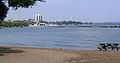
 Pier 4 Park, Hamilton, Ontario
 -
 Beach seen from Toronto, Ontario's Humber Bay, west of downtown
 -

-
 From Toronto lakeshore in winter
 -
A glimpse of Lake Ontario
-
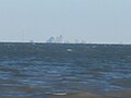 The Toronto skyline viewed from across Lake Ontario (Niagara-on-the-Lake, Ontario)


See also
Great Lakes in General
- Great Lakes
- Great Lakes Areas of Concern
- Great Lakes census statistical areas
- Great Lakes Commission
- Great Recycling and Northern Development Canal
- Great Storm of 1913
- International Boundary Waters Treaty
- List of cities along the Great Lakes
- Seiche
- Sixty Years' War for control of the Great Lakes
- Third Coast
References
- ^ a b c d e f g Wright, John W. (ed.) (2006). The New York Times Almanac (2007 ed.). New York, New York: Penguin Books. p. 64. ISBN 0-14-303820-6.
{{cite book}}:|first=has generic name (help); Unknown parameter|coauthors=ignored (|author=suggested) (help) - ^ Museum of Civilization
- ^ Great Lakes Circle Tour.
- ^ The Morning Post (London, England), Saturday, July 25, 1835; pg. 6 "Sea Serpent in Lake Ontario"
- ^ Glasgow Herald (Glasgow, Scotland), Friday, June 28, 1867 "Another Sea Serpent Sensation: A hideous monster discovered in Lake Ontario"
- ^ http://www.helium.com/items/577807-the-lake-ontario-monster-revealed
- ^ Pinkwater, Daniel. The Monster of Lake Ontario. New York: Houghton Mifflin Publishing, 2010, pg. 46-47.
External links
- Lake Ontario United
- Lake Ontario Waterkeeper
- EPA's Great Lakes Atlas
- Great Lakes Coast Watch
- Pollution in the Great Lakes
- Lake Ontario Bathymetry
Great Lakes of North America | |||||||||||||
|---|---|---|---|---|---|---|---|---|---|---|---|---|---|
| Main lakes | |||||||||||||
| Secondary lakes | |||||||||||||
| Bays and channels |
| ||||||||||||
| Waterways | |||||||||||||
| Islands | |||||||||||||
| Historic geology | |||||||||||||
| Organizations |
| ||||||||||||
| Related topics |
| ||||||||||||