Lake Erie

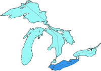
Lake Erie (pronounced [ˈi.ɹi]) is the most southern of the five Great Lakes of North America. It is bounded on the north by Ontario, on the south by the states of Ohio, Pennsylvania, and New York, and on the west by the state of Michigan. The lake is named after the Erie tribe of Native Americans who lived along its southern shore before European contact.
The lake creates a favorable environment for agricultural pursuits in the bordering areas of Canada, Ohio, Pennsylvania, and New York. In addition, its waters are home to numerous fish species, making it a popular site for commercial fishing. However, since high levels of pollution were discovered in the 1960s and 1970s, there has been continued debate over the extent of commercial fishing and measures used to protect the lake.
Geography

Lake Erie (42º30'N, 81°00'W) is the world's 13th largest natural lake, if the Caspian and Aral Seas are counted. The lake has an elevation of 569 ft (173 m) above sea level. It has a surface area of 9,910 sqmi (25,700 km²) with a length of 241 mi (388 km) and breadth of 57 mi (92 km) at its widest points. The average depth is 62 ft (19 m) with a maximum depth of 210 ft (64 m). The western section, comprising 1/4 of the area is shallower with an average depth of 42 ft (13 m) and a maximum depth of 62 ft (19 m).
For comparison, Lake Superior has an average depth of 483 ft (147m), a volume of 2,900 cu. mi. (12,100 km³) and shoreline of 2,726 mi (4385 km).

Lake Erie is primarily fed by the Detroit River (from Lake Huron and Lake St. Clair) and drains via the Niagara River and Niagara Falls into Lake Ontario. Navigation downstream is provided by the Welland Canal, part of the Saint Lawrence Seaway. Other major tributaries of Lake Erie include the Grand River, the River Raisin, the Huron River, the Maumee River, the Sandusky River and the Cuyahoga River.
The American states Ohio, Pennsylvania and New York are located to the south of Lake Erie; Michigan lies to the west, and the Canadian province of Ontario lies to the north. Point Pelee National Park, the southernmost point of the Canadian mainland, is located on a peninsula extending into the lake. Several islands are found in the western end of the lake; these belong to Ohio except for Pelee Island, which is part of Ontario.
The cities of Buffalo, New York; Erie, Pennsylvania; Toledo, Ohio; Monroe, Michigan; and Cleveland, Ohio are located on the shores of Lake Erie. It was the last of the Great Lakes discovered by the French explorers, who had followed rivers out of Lake Ontario and portaged into Lake Huron.
History
In 1669, the Frenchman Louis Jolliet discovered Lake Erie which led to French settlements being established a few years later.
Lake Erie is the shallowest of the Great Lakes and infamously became very polluted in the 1960s and 1970s. Urban legend has described it as a dead lake, but both sport and commercial fishing have continued without interruption to the present day. Pollution in the lake did not get much attention until the great Cuyahoga River Fire in June of 1969. Pollution from Cleveland and other Ohio cities had so contaminated this tributary of Lake Erie with petrochemicals that it actually caught on fire. The fire embarrassed state officials and prompted the U. S. Congress to pass the Clean Water Act.
Ecology

Leamington, Ontario
Like the other Great Lakes, Erie produces lake effect snow when the first cold winds of winter pass over the warm waters, leading to south Buffalo being one of the snowiest places in the United States. The effect ends, however, when the lake freezes over, which it frequently does.
The lake is also responsible for microclimates that are important to agriculture. Along its north shore is one of the richest areas of Canada's fruit and vegetable production, and along the southeastern shore in Ohio, Pennsylvania, and New York is an important grape growing region.
Environmental regulation led to a great increase in water quality and the return of fresh water fish and other biological life; however, invasive Zebra and Quagga mussels currently threaten the entire Lake Erie ecosystem.
Other invasive species, such as the goby and the grass carp, have increased awareness of how fragile the lake is at the present time. During the 1970s, Lake Erie's future was jeopardized by the overabundance of phosphorus in the water, which resulted in rank smelling algal blooms fouling both cobbled and sandy beaches. A 1972 agreement between Canada and the United States has reduced the dumping and runoff of phosphorus into the lake significantly. However, the continuing cycle of phosphorus-fed algae blooms and the subsequent decay of algae has contributed to the development of a dead zone in the central Lake Erie basin during the late summer. The U.S. Environmental Protection Agency is currently studying this cyclic phenomenon.[1]
Still, there is controversy over whether there should be a commercial fishery on the lake. Commercial fleets, berthed at 11 communities along the shoreline, are restricted to keeping 11 species, of the 140 fish species present in Erie, for their catch through the use of gill nets, while anglers have the chance to fish for 18 species with rod and reel.
Walleye and yellow perch are game fish at the center of the debate. Anglers—both in the United States and Canada—believe that the quotas set for the commercial industry are over-generous, and possibly could lead to the crash of all fish species.
Sports fishermen, who operate by the policy of catch-and-release, are concerned that the 80% of the fish harvested from the lake by the commercial industry is too high. They believe the future of the Lake Erie's fish resources should be maintained through conservation instead of outright exploitation.
Lake Erie's shallowness also makes it particularly prone to seiches, especially during storms, when the lake water tends to pile up at one end of the lake. This can lead to huge storm surges, potentially causing damage onshore. During one storm in November 2003, the water level at Buffalo rose by 7 feet (2.1 m) with waves of 10-15 feet (3-4.5 m) on top of that, for a cumulative rise of as much as 22 feet (6.7 m). Meanwhile, Toledo at the western end of the lake will measure similar drops in water level. After the storm event, the water will slowly slosh back and forth, similar to the effect in a bath tub, until equilibrium is re-established.
Geology
Lake Erie has a lake retention time of 2.6 years, which is the shortest of all the Great Lakes.
Lake Erie Islands


- Big Chicken Island
- Chick Island
- East Sister Island
- Gibraltar Island
- Green Island
- Gull Island
- Hen Island
- Johnson's Island
- Kelleys Island
- Little Chicken Island
- Lost Ballast Island
- Middle Island
- Middle Bass Island
- Middle Sister Island
- Mouse Island
- North Bass Island
- North Harbour Island
- Pelee Island
- Rattlesnake Island
- South Bass Island
- Starve Island
- Sugar Island
- Turtle Island
- West Sister Island
See also
- Cedar Point
- Bass Islands
- Erie Canal
- Welland Canal
- Maumee Bay
- Bessie the Lake Erie sea monster
References
- ^ Lake Erie 'Dead Zone'. US EPA Lake Erie 'Dead Zone'. URL accessed on December 15, 2005.
