
Union Falls
| Union Falls | |
|---|---|
 Union Falls | |
 | |
| Location | Yellowstone National Park, WY, US |
| Coordinates | 44°11′34″N 110°52′15″W / 44.19278°N 110.87083°W[1] |
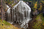
| Type | Fanny |
| Total height | 250 feet (76 m) |
| Number of drops | 1 |
| Watercourse | Mountain Ash Creek |
Union Falls ht. 250 feet (76 m) is a waterfall on Mountain Ash Creek, a tributary of the Fall River in the Cascade Corner (southwest) of Yellowstone National Park. It is the second highest waterfall in Yellowstone exceeded in height only by the lower Yellowstone Falls. The falls got its name from members of the Arnold Hague Geological Surveys sometime between 1884-86. Geologist J.P. Iddings claims the name derives from the fact that a tributary of Mountain Ash Creek joins at the very brink of the falls, thus Union Falls.[2] Access to the falls is via the Mountain Ash Creek trail and the Grassy Lake Road.
Images of Union Falls
-
 Union Falls in Autumn

See also
Notes
- ^ "Union Falls". Geographic Names Information System. United States Geological Survey, United States Department of the Interior.
- ^ Whittlesey, Lee (1996). Yellowstone Place Names. Gardiner, MT: Wonderland Publishing Company. p. 174. ISBN 1-59971-716-6.
Yellowstone National Park - Cascade Corner | ||
|---|---|---|
Rivers, waterfalls, peaks and lakes in the Cascade Corner (Southwest) section of the park | ||
| Rivers |  | |
| Waterfalls and cascades | ||
| Lakes and peaks | ||
| ||