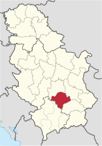
Toplica District
Toplički okrug Топлички округ | |
|---|---|
 Location of Toplica District in Serbia | |
| Country | |
| Capital | Prokuplje |
| Government | |
| • Commissioner | n/a |
| Area | |
| • Total | 2,231 km2 (861 sq mi) |
| Population (2011 census) | |
| • Total | 91,754 |
| • Density | 41.1/km2 (106/sq mi) |
| Municipalities | 4 |
| Settlements | 267 |
| - Cities and towns | 4 |
| - Villages | 263 |
The Toplica District (Serbian: Toplički okrug, Serbian Cyrillic: Топлички округ, pronounced [tǒplit͡ʃkiː ôkruːɡ]) expands in the southern part of Serbia . It has a population of 91,754 and has been named after the river Toplica. Seat of the District is in the city of Prokuplje.
Municipalities
It encompasses the municipalities of:
Demographics
Albanians made up the majority of the population of Toplica in the late 19th century and early 20th century.[1] According to the last official census done in 2011, Toplica District has 91,754 inhabitants. Most of its population is of Serbian nationality (93.46%) while 50.02% of the municipality’s population is urban.
Ethnic composition of the municipality:
| Ethnic group | Population |
|---|---|
| Serbs | 85,750 |
| Roma | 3,945 |
| Montenegrins | 176 |
| Macedonians | 97 |
| Romanians | 76 |
| Croats | 50 |
| Others | 1,660 |
| Total | 91,754 |
Economy
The Toplički District is a medium developed industrial center, in which the most prominent are the "Prokupac" - alcoholic beverage factory, the "Hissar" food factory, the "FOM" ferrous metal plant and the "Topličanka" cotton mill.
See also
References
External links
Note: All official material made by Government of Serbia is public by law. Information was taken from official website.
